Situation Summary
Burkina Faso remains the most terrorism-affected country globally, with conflict-related violence killing approximately 7,600 people in 2023 and displacing over 2 million civilians. The military controls approximately 30% of national territory, while armed groups employ siege tactics against roughly 130 towns and cities, with major supply corridors to neighboring states cut or severely restricted. A recent administrative sanction against parliament signals potential internal political tension. The security environment continues to degrade, driven by sustained militant expansion and operational pressure on state forces across multiple regions.
Key Developments
- Ouagadougou & nationwide: Security forces implemented heightened checkpoint and patrol operations following coordinated attacks in neighboring Mali; government called for public reports of suspicious activity near military barracks, airports, and administrative buildings, indicating elevated threat posture.
- Western & northern transport corridors: Militant groups continue to sever major routes linking Ouagadougou to Togo, Benin, Niger, Mali, and Côte d'Ivoire, significantly restricting commercial and personnel movement.
- Djibo, Di, Diapaga, Foutouri, Lanfiera, Solenzo, Sollé, Thiou, Yamba: Sustained militant attacks on military barracks across these locations in 2025 demonstrate persistent pressure on state security infrastructure in northern and eastern zones.
- Nationwide administrative: Parliament faced sanctions on 2026-06-01; nature and scope require monitoring for potential governance instability that could affect security policy or operational coherence.
- Education & civilian services: Approximately one-quarter of schools remain closed, affecting nearly 1 million students and reflecting underlying instability that compounds travel risk and reduces predictability of civilian movement patterns.
- Terrorist designation: The Atlantic Council confirmed Burkina Faso as the country most affected by terrorism in the latest Global Terrorism Index, with extremist violence worsening under current junta governance.
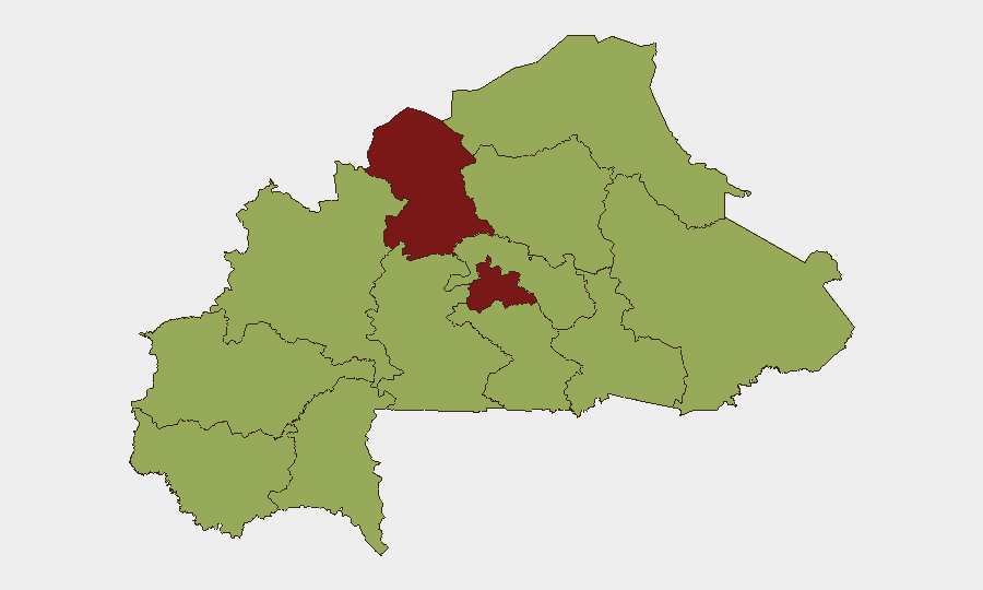
Highest-Risk Areas
The North region (risk score 89.6) and Centre region (84.6) drive the composite national threat score and warrant priority focus. The North faces the highest sustained militant activity, barracks attacks, and territorial control loss. The Centre, encompassing Ouagadougou and surrounding areas, experiences pressure from militants cutting supply lines and coordinated intelligence operations by state forces, creating volatility around checkpoints and administrative hubs. All remaining regions score 59.6, reflecting widespread but lower-intensity conflict dispersal. Risk concentration in the North and Centre indicates that operations, travel, and personnel in these zones face substantially elevated exposure compared to the south and southwest.
How GeoBit Would Assist
Intel Sweep & OSINT Fusion would aggregate real-time reporting from local media, social networks, and militant communications to detect emerging attack patterns, checkpoint operations, or supply-route changes affecting personnel or asset movements. AOI Monitoring & Early Warning would establish persistent geographic watches on the North and Centre regions, flagging new militant activity, barracks pressure, or security force repositioning within 24–48 hours of occurrence. Routing & Network Analysis would enable security teams to model alternative supply and personnel routes around active militant siege zones and cut corridors, updating dynamically as conflict geometry shifts.
7-Day Outlook
Militant operational tempo is likely to remain elevated in the North and Centre, with barracks and checkpoint targeting expected to continue. The parliamentary sanction on 2026-06-01 warrants 7–10 day close monitoring for secondary governance announcements or policy shifts that could affect military command coherence or internal security operations. Personnel and asset movements should assume sustained risk in checkpointed areas and severed corridors; no near-term de-escalation indicators are present.
Highest-Risk Areas — Ranked
| # | State / Region | Risk |
|---|---|---|
| 1 | North | 89.6 |
| 2 | Centre | 84.6 |
| 3 | Upper-Basins | 59.6 |
| 4 | Boucle du Mouhoun | 59.6 |
| 5 | Central-West | 59.6 |
| 6 | Central-South | 59.6 |
| 7 | Central-East | 59.6 |
| 8 | Waterfalls | 59.6 |
| 9 | Southwest | 59.6 |
| 10 | Sahel | 59.6 |
| 11 | Central-North | 59.6 |
| 12 | East | 59.6 |