Situation Summary
Chad remains at heightened risk (global rank #25, composite score 72) due to convergent terrorism, military operations, and transnational armed-group activity, particularly in the Lake Chad Basin and border regions. The government's 20-day state of emergency in the western Lake Chad region—triggered by Boko Haram attacks that killed 26 soldiers and two generals—reflects the acute threat environment and expanding security operations. Nationwide travel constraints, weak governance outside N'Djamena, landmine contamination, and persistent kidnapping risk create a fragmented security picture where risk varies sharply by region and movement patterns.
Key Developments
- Lake Chad region state of emergency (ongoing): Government declared 20-day emergency following May Boko Haram attacks; security forces now empowered to restrict movement, conduct warrantless searches, and seize weapons. Civilian displacement continues.
- Barka Tolorom military base (Lac state): Site of May ambush killing 24 soldiers; Boko Haram/ISWAP presence remains active on Lake islands and tri-border zone (Nigeria–Niger–Cameroon), with elevated risk of further ambushes and IED incidents.
- Border terrorism (Lake Chad Basin): U.S. authorities identify the Nigeria border (Borno State) as Boko Haram and ISIS-WA stronghold; cross-border raids and attacks on military posts and humanitarian convoys remain consistent threat.
- U.S.–Chad diplomatic tensions (2026-06-01 to 02): Multiple public statements indicate escalation; context and operational impact to be monitored for cascading effects on foreign-mission security posture and visa/travel policy changes.
- N'Djamena crime and checkpoints: Capital reports elevated violent crime (armed robbery, carjacking, sexual assault) alongside frequent police roadblocks and solicitation of bribes, particularly after dark.
- Restricted consular assistance outside capital: U.S. government reports extremely limited ability to provide emergency assistance outside N'Djamena; staff require armed escorts and special authorization, indicating structural gap in duty-of-care coverage.
- Landmine and UXO contamination (remote regions): Northern and border zones remain heavily contaminated; overland travel in sparsely governed areas carries elevated risk of casualties.
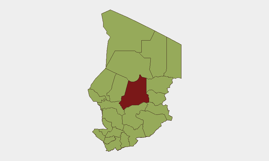
Highest-Risk Areas
Batha state (risk 80.4) stands as the primary driver of national risk, reflecting intensity of military operations and Boko Haram/ISWAP activity in the Lake Chad Basin. Ennedi-Ouest, Wadi Fira, Ouaddaï, Sila, Salamat, East Ennedi, Kanem, Lac, and Chari-Baguirmi form a contiguous band of elevated risk (50.4 each) spanning the north and east—these regions are characterized by weak state presence, porous borders with Nigeria and Niger, active militant sanctuaries, and landmine prevalence. Even N'Djamena (risk 50.4) registers at this level due to crime and checkpoint-related security incidents. Risk concentration in these northern and eastern zones reflects the Lake Chad Basin conflict zone and cross-border terrorism networks; southern and central regions (not listed in top tier) remain relatively lower-risk.
How GeoBit Would Assist
Security teams should leverage AOI Monitoring & Early Warning to establish persistent watch on Lac, Batha, and border zones, with alerts triggered by military movements, armed-group activity, or checkpoint/protest escalation. OSINT fusion and multi-language search across X/Telegram and local sources enable near-real-time situational awareness of Boko Haram claims, government operations tempo, and diplomatic statements affecting policy. Routing & Network Analysis supports identification of secure movement corridors and avoidance of landmine-contaminated or high-ambush-risk routes for personnel and asset transits.
7-Day Outlook
The state of emergency and intensified military operations in Lake Chad are expected to persist through early June, with security-force posture remaining elevated. Diplomatic tensions between Chad and the U.S. may influence consular support availability and mission staffing decisions. Travel risk in the Lake Chad Basin, border regions, and remote north will remain acute; N'Djamena crime and checkpoint harassment should be assumed constant absent policy change.
Highest-Risk Areas — Ranked
| # | State / Region | Risk |
|---|---|---|
| 1 | Batha | 80.4 |
| 2 | Ennedi-Ouest | 50.4 |
| 3 | Wadi Fira | 50.4 |
| 4 | Ouaddaï | 50.4 |
| 5 | Sila | 50.4 |
| 6 | Salamat | 50.4 |
| 7 | East Ennedi | 50.4 |
| 8 | Kanem | 50.4 |
| 9 | Lac | 50.4 |
| 10 | N'Djamena | 50.4 |
| 11 | Hadjer-Lamis | 50.4 |
| 12 | Chari-Baguirmi | 50.4 |