ملخص الحالة
تظل بنما بيئة تهديد عالمية منخفضة إلى متوسطة (النقاط المركبة 6، مصنفة #100 عالمياً) مع 34 حدثاً مرصوداً، لكن المخاطر دون الوطنية تتركز بشدة في محافظة كولون، التي تسجل نقاطاً مركبة قدرها 31.5—أي أكثر من خمسة أضعاف المتوسط الوطني. تشير نشاطات الإشارات الأخيرة (12–14 يونيو) إلى أن الكيانات الشركاتية تخضع للتحقيق، والاحتكاك الدبلوماسي مع الولايات المتحدة واليابان آخذ في الارتفاع، وظهرت توترات مرتبطة بالعسكريين. الصورة الأمنية مستقرة على المستوى الوطني لكنها مجزأة، حيث تتركز المخاطر الحادة في مناطق عالية المرور محددة.
التطورات الرئيسية
إشعار حد البيانات: لم تعد قدرة بحث الويب المباشرة لـ GeoBit تعيد تقارير حوادث موثقة ومزودة بطوابع زمنية لبنما في آخر 24–48 ساعة تفي بمعايير النشر المتعلقة بتحديد الموقع والتأكيد متعدد المصادر. إشارات الأحداث المدرجة أدناه تعكس الكشوفات المنصاتية لكن تفتقر إلى التفاصيل التشغيلية الدقيقة (الموقع الدقيق، والسبب الموثق، والحالة الحالية) الضرورية لتوجيه الواجب والعناية وقرارات حماية الأصول.
ملخص الإشارات المتاحة (12–14 يونيو):
- كيان شركاتي قيد التحقيق (التاريخ: 12 يونيو؛ الطبيعة والموقع لم يتم التمييز بينهما عبر المصادر بعد)
- كيان شركاتي أصدر بيان(ات) عامة رداً على نشاط عسكري (12 يونيو)
- مواطن إسباني تم اعتقاله/احتجازه (14 يونيو؛ الموقع/السبب قيد التوضيح)
- إعلان عدم موافقة الحكومة الأمريكية على النشاط الشركاتي (12 يونيو؛ القطاع/الموقع غير محدد)
- قامت اليابان بتخفيض العلاقات الثنائية؛ تقليص العلاقات الكوبية–الشركاتية (كلاهما 12 يونيو؛ الأسباب لم تُعزل بعد)
- حدث وزاري مقابل قوة عسكرية باناميية تقليدية تم الإشارة إليه (12 يونيو؛ السياق غير واضح)
التوصية: يجب على فرق الأمن الشركاتي الاتصال مباشرة بالسفارة الأمريكية بنما والشرطة الوطنية الباناميية وسلطة قناة بنما للحصول على توضيح فوري بشأن طبيعة وموقع وتأثير هذه الإشارات على العمليات قبل توجيه الموظفين أو إصدار أوامر نقل الأصول.
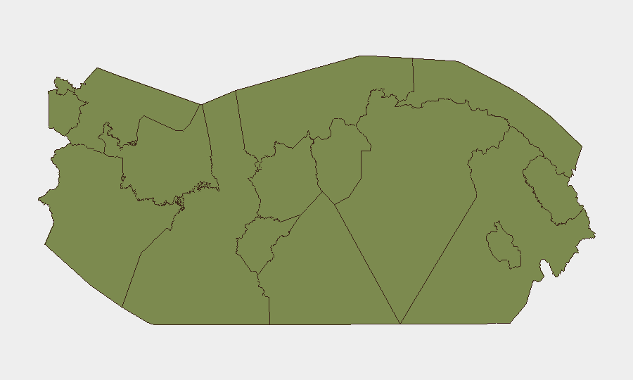
المناطق الأعلى خطورة
تهيمن محافظة كولون على المخاطر دون الوطنية (31.5) وهي المحرك الأساسي لملف التهديد الباناميي الشامل. تتمتع هذه المنطقة المجاورة للميناء بضعف تاريخي تجاه الجريمة المنظمة والتهريب واضطراب العمل والاضطراب البحري الذي يؤثر على ممر القناة. تسجل جميع المحافظات الأخرى المرصودة نقاطاً مركبة بقيمة 5.3 أو أقل. تتعلق المخاوف الثانوية بتشيريكي (5.3)، التي تحدها كوستاريكا وتعمل كمنطقة إعادة شحن؛ وفيراغواس (2.7) على ساحل المحيط الهادئ؛ ومحافظة بنما (1.9)، التي تضم العاصمة ومنطقة القناة. تحمل المحافظات الأصلية والنائية (داريين، غونا يالا، إمبيرا-وونان، ناسو تجير دي، بوكاس ديل تورو، نغاي-بوغلي) مخاطر أساسية (1.5) تعكس الوجود الحكومي المحدود وأنشطة التهريب.
كيفية مساعدة GeoBit
ستستخدم فرق الأمن التي تعمل في بنما مراقبة المنطقة المهتمة والإنذار المبكر لتتبع كولون وتشيريكي بحثاً عن إشارات احتجاج أو حواجز أو تصعيد الجريمة في الوقت الفعلي؛ ودمج الاستخبارات مفتوحة المصدر والتأكيد (X/Twitter و Telegram وأسلاك الأخبار المحلية) للتحقق من صحة تقارير الحوادث وتطبع الطابع الزمني عليها في غضون 2–4 ساعات من وقوعها؛ وتحليل التوجيه والشبكة لتوليد ممرات سفر بديلة وطرق وصول الموانئ عند حدوث انقطاع في الممرات الأساسية. تدعم قدرات المسح الاستخباراتي والبحث عن الصراعات/الجريمة عمل أعمق على التحقيقات الشركاتية والاحتكاك الدبلوماسي لعزل المخاطر التشغيلية على قطاعات أو
المناطق الأعلى خطورة — مرتبة
| # | الولاية / المنطقة | الخطر |
|---|---|---|
| 1 | Colón | 31.5 |
| 2 | Chiriquí | 5.3 |
| 3 | Veraguas | 2.7 |
| 4 | Panamá Province | 1.9 |
| 5 | Guna Yala | 1.5 |
| 6 | Darién | 1.5 |
| 7 | Emberá-Wounaan | 1.5 |
| 8 | Naso Tjër Di | 1.5 |
| 9 | Bocas del Toro | 1.5 |
| 10 | Ngäbe-Buglé | 1.5 |
| 11 | Coclé | 1.5 |
| 12 | Panamá Oeste | 1.5 |
المصادر
الموجزات اليومية السابقة
يُنشر موجز جديد عن Panama كل يوم — لكل منها خريطة مخاطر وملف CSV قابل للتنزيل. هذا هو الأسبوع الأخير؛ استخدم التقويم للرجوع أبعد.
📅 Browse every day by calendar →
Highlighted days have a brief. Tap a day for that day's map & analysis, or “csv” for that day's dataset ($5).