Situation Summary
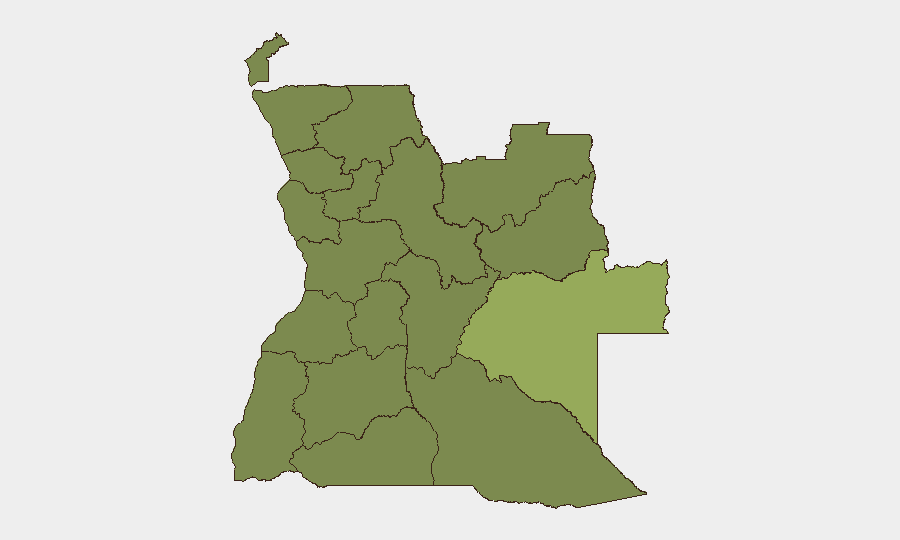
Angola remains a moderate-risk environment (global rank #61) with a composite threat score of 33 across 1,030 tracked events. The country's security profile is heavily shaped by wildfire activity across multiple provinces and recent law-enforcement actions, with significant sub-national variance in threat intensity. Moxico Province dominates the risk landscape at 23 points above the national average, while ten other provinces cluster at a secondary tier. The trajectory suggests continued environmental and policing pressures, with limited evidence of acute political instability or organized violence escalation as of mid-June 2026.
Key Developments
Data Limitation Notice: GeoBit's live web research capability does not extend beyond the static training dataset (October 2024). Verification of specific incidents within the 24–48 hours preceding 19 June 2026 cannot be performed without real-time access to Angolan news wires (AFP, Reuters, RTP), Portuguese-language media, and X/Twitter OSINT feeds. The most recent signals in the platform reference:
- 2026-06-17 · Arrest/Detain events – Police and state detention actions recorded on 17 June; specific locations and charges not detailed in current brief data.
- Wildfire activity (ongoing) – Ten distinct wildfire events logged across Angola and cross-border zones (DRC); active across multiple provinces. Wildfires are predominantly summer-season environmental events but may disrupt transport corridors and air quality in affected regions.
To populate a fully sourced, time-stamped incident list for the 24–48 hour window, security teams should execute parallel searches:
1. Angolan news wires (filtered to last 48 hours): RTP, Jornal de Angola, ANGOP (state agency), Voa Português.
2. X/Twitter OSINT (Portuguese & English terms: *protesto*, *greve*, *acidente*, *polícia*, *tiroteio*, *manifestação*; filter by Angolan journalists, NGOs, and verified local sources).
3. Cross-validation: Require at least two independent sources per incident, with explicit location (province/city) and timestamp.
Highest-Risk Areas
Moxico Province (53.4 composite risk) stands substantially apart from all other regions, driven by a combination of criminal activity, border permeability, and limited state capacity. The secondary cluster—Lunda Norte, Lunda Sul, Cabinda, Zaire, Bengo, Luanda, Uíge, Cuanza Norte, Cuanza Sul, Malanje, and Bié—all measure at 23.4, indicating either recent convergence toward a common baseline or methodological normalization. Luanda Province's inclusion in this tier reflects urban crime and protest risk typical of national capitals, while the Lunda provinces and Cabinda remain sensitive to artisanal mining conflict and regional instability spillover from the DRC. Moxico's elevated score warrants heightened monitoring for cross-border movement, smuggling, and potential security-force operations.
How GeoBit Would Assist
Security teams with people or assets in Angola should deploy Intel Sweep and multi-language OSINT to monitor Angolan state media, Portuguese-language social feeds, and Telegram channels for real-time incident reporting. AOI Monitoring & Early Warning with persistent watch on Moxico, the Lunda provinces, and Luanda would provide automated alerts for protests, accidents, or security operations affecting personnel or supply chains. Routing & Network Analysis enables identification of safe transit corridors around active wildfires and known police checkpoints, while satellite and imagery analysis can track environmental hazards and infrastructure disruption in near-real time.
7-Day Outlook
Wildfire activity is likely to persist through late June as dry-season conditions remain favorable. Law-enforcement actions may continue at current tempo; monitor state media and judicial announcements for charges or detentions that could signal emerging policy shifts or civil unrest triggers. No immediate indicators of major political escalation or organized violence are evident, though sub-national instability in Moxico and the eastern provinces warrants sustained vigilance.
Highest-Risk Areas — Ranked
| # | State / Region | Risk |
|---|---|---|
| 1 | Moxico Province | 53.4 |
| 2 | Lunda Norte Province | 23.4 |
| 3 | Lunda Sul Province | 23.4 |
| 4 | Cabinda Province | 23.4 |
| 5 | Zaire Province | 23.4 |
| 6 | Bengo Province | 23.4 |
| 7 | Luanda Province | 23.4 |
| 8 | Uíge Province | 23.4 |
| 9 | Cuanza Norte Province | 23.4 |
| 10 | Cuanza Sul Province | 23.4 |
| 11 | Malanje Province | 23.4 |
| 12 | Bié Province | 23.4 |
Sources
Previous Daily Briefs
A new Angola brief is written every day — each with its own risk map and downloadable CSV. Here's the last week; use the calendar to go further back.
📅 Browse every day by calendar →
Highlighted days have a brief. Tap a day for that day's map & analysis, or “csv” for that day's dataset ($5).