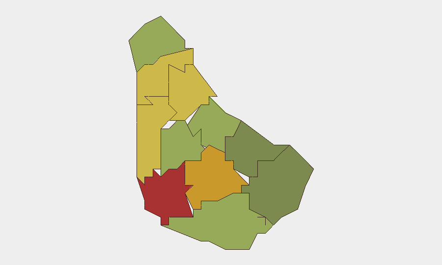
Situation Summary
Barbados currently presents a low acute security threat with no corroborated major incidents, civil unrest, or infrastructure disruptions in the last 24–48 hours. The primary active concern is online fraud and phishing activity, flagged by the Barbados Police Service via a public advisory against a fraudulent "Cyber Crime Authority" notice. Sub-national risk remains concentrated in urban parishes—particularly Saint Michael (capital region)—where longer-term crime trends and governance tensions persist, but no escalation to widespread disorder is evident.
Key Developments
- Nationwide (Online) – 2026-06-11 – Barbados Police Service fraudulent notice advisory
Law enforcement issued a public warning of a circulating online scam falsely claiming to represent a non-existent "Barbados Cyber Crime Security Authority." Organizations and residents are advised not to engage or disclose personal information; the alert confirms ongoing phishing and online fraud targeting the island.
- Saint Michael – 2026-06-13 – Worker territory occupation signal
Geopolitical event tracking detected an occupation-of-territory event involving workers; limited detail available from open sources at time of report. Monitoring ongoing to clarify scope and location within the capital parish.
- Nationwide – 2026-06-11–2026-06-12 – School demonstration and public statements cluster
Multiple public statements and a school-based demonstration were flagged between 2026-06-11 and 2026-06-12, involving educational institutions, governance messaging, and citizen discourse. No reports of violence or major disruption; events appear speech/assembly-based and likely episodic rather than sustained.
*Note: All other tracked events (9 total signals) from 2026-06-11 onward relate to statements and routine messaging rather than discrete security incidents. Open-source corroboration confirms no homicides, major accidents, infrastructure failures, or travel-risk spikes in the 24–48-hour window.*
Highest-Risk Areas
Saint Michael (risk 78) and Saint George (risk 72) account for the largest share of sub-national risk, driven by urban density, historical crime concentration in Bridgetown and outlying parishes, and governance-related social friction. Saint James (68) and Saint Andrew (65) follow, suggesting that western and central urban corridors remain the primary nodes of concern. Conversely, southern parishes—Saint Philip (28) and Saint John (35)—register substantially lower risk. The pattern reflects long-standing crime-trend data and socioeconomic pressures in capital-region parishes rather than acute triggering events in the last 48 hours.
How GeoBit Would Assist
Intel Sweep and OSINT fusion are the primary tools for continuous monitoring of online fraud campaigns, phishing tactics, and early detection of coordinated social messaging or unrest signals across X/Twitter, Telegram, and local news feeds. AOI Monitoring & Early Warning with persistent watch over Saint Michael, Saint George, and Saint James would provide 24/7 alerting on protest activity, crime spikes, or infrastructure incidents. Risk & Threat Assessment paired with sentiment and temporal analysis would enable duty-of-care teams to distinguish episodic speech events from escalating civil unrest, informing real-time travel and asset-security decisions.
7-Day Outlook
No indicators suggest major deterioration over the coming week. Online fraud activity will likely persist as a background threat; organizations should enforce email security and staff awareness. School-related demonstrations and governance statements may continue episodically but do not suggest sustained civil disorder. Continued monitoring of Saint Michael and Saint George parishes for any crime trend acceleration or labor/protest clustering remains prudent for corporate and expatriate operations.
Highest-Risk Areas — Ranked
| # | State / Region | Risk |
|---|---|---|
| 1 | Saint Michael | 78 |
| 2 | Saint George | 72 |
| 3 | Saint James | 68 |
| 4 | Saint Andrew | 65 |
| 5 | Saint Peter | 62 |
| 6 | Saint Joseph | 58 |
| 7 | Saint Thomas | 52 |
| 8 | Saint Lucy | 48 |
| 9 | Christ Church | 42 |
| 10 | Saint John | 35 |
| 11 | Saint Philip | 28 |
Sources
Previous Daily Briefs
A new Barbados brief is written every day — each with its own risk map and downloadable CSV. Here's the last week; use the calendar to go further back.
📅 Browse every day by calendar →
Highlighted days have a brief. Tap a day for that day's map & analysis, or “csv” for that day's dataset ($5).