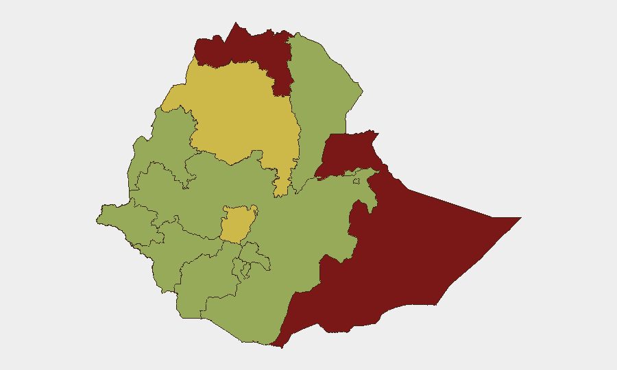
Situation Summary
Ethiopia remains in active civil conflict with a composite threat score of 82.6, driven primarily by armed insurgencies across multiple regions and ongoing state-of-emergency conditions in key population centers. The conflict landscape is fragmenting geographically—with the Somali Region (87.8), Tigray (84.6), and Amhara Region (70.7) representing the highest-risk zones—while secondary threats including petty crime in Addis Ababa, disease outbreaks (Marburg, malaria), and communications disruptions compound operational risk. The security situation shows no signs of near-term de-escalation, with fresh clashes reported as recently as 2 June 2026.
Key Developments
- Oromia Region (East Wollega Zone, Nekemte): Armed clashes between federal/regional forces and Oromo Liberation Army (OLA/Shane) fighters reported 2 June; secondary roads blocked, checkpoints increased, and telecom disruptions affecting rural kebeles.
- Amhara Region (North Gondar & West Gojjam): Continued fighting between federal/Amhara forces and Fano militias under regional state-of-emergency; curfews and movement controls in place on routes from Bahir Dar to Gondar and Debre Tabor, creating unpredictable travel conditions.
- Addis Ababa (Piazza, Mercato): Elevated petty crime and opportunistic theft targeting foreigners and business travelers; violent crime increases markedly after dark in poorly lit areas.
- Northern Border Zones (Tigray, Afar, Eritrea frontier): Classified "do not travel" by international advisories; ongoing conflict, unrest, landmine threat, and banditry on remote corridors remain unresolved.
- Western Frontier (Benishangul-Gumuz, Gambella, Sudan/South Sudan borders): Persistent kidnapping, armed-group activity, and crime affecting aid workers and extractive-sector personnel; kidnap-for-ransom and road-attack risk elevated.
- Eastern Border (Somali Region, Somalia/Kenya frontier): Terrorism, landmines, and militant groups capable of targeting security forces and foreigners; overland travel in remote districts strongly discouraged.
- Central & South Ethiopia (North, West, Southwest Shewa, Guji, Borena): High risk of snap clashes, ethnically motivated violence, roadblocks, and communications shutdowns on main and secondary routes to Addis Ababa and regional hubs.
- Nationwide Communications & Administrative Barriers: Internet, cellular data, and phone services subject to shutdown before/during unrest; exit bans imposed on foreigners for immigration violations; credible terrorism threat targeting Western and government-linked targets.
Highest-Risk Areas
Somali Region (87.8), Tigray (84.6), and Amhara Region (70.7) drive the national composite threat score, reflecting active armed conflict, militant activity, and state-of-emergency governance. Somali and Tigray face overlapping threats of terrorism, landmines, and cross-border instability; Amhara's risk stems from persistent Fano militia confrontations and federal military operations. A secondary tier—Afar, Benishangul-Gumuz, Gambella, and Central Ethiopia (62.1)—presents significant kidnapping, banditry, and ethnic-violence risk, particularly along Sudan/South Sudan frontiers and on routes connecting regional hubs. Addis Ababa, despite its cosmopolitan profile, registers composite risk of 57.8, driven by petty crime, terrorism threat, and governance volatility.
How GeoBit Would Assist
Security teams would leverage AOI Monitoring & Early Warning to track flash-violence and clashes in high-risk zones (Amhara, Oromia, Somali), with OSINT fusion (X/Telegram, local news, diaspora outlets) to detect emerging clashes and roadblock activity in real time. Routing & Network Analysis capabilities enable alternative journey planning to avoid active conflict zones and checkpoints; Communications & Regime Stability intelligence helps predict shutdown events before they occur. Conflict & Military tracking, combined with satellite imagery analysis, supports situational awareness of force movements and access restrictions on key supply and travel corridors.
7-Day Outlook
No imminent deescalation is expected. Fresh clashes in Oromia and Amhara suggest operational tempo remains elevated, and the ongoing state of emergency in multiple regions indicates authorities anticipate continued unrest. Road closures, checkpoints, and communications disruptions are likely to persist or expand over the next week, particularly if clashes intensify around Nekemte, Gondar, or secondary routes in central Shewa.
Highest-Risk Areas — Ranked
| # | State / Region | Risk |
|---|---|---|
| 1 | Somali Region | 87.8 |
| 2 | Tigray | 84.6 |
| 3 | Amhara Region | 70.7 |
| 4 | Central Ethiopia Regional State | 62.1 |
| 5 | Afar Region | 57.8 |
| 6 | Benishangul-Gumuz Region | 57.8 |
| 7 | Gambela Region | 57.8 |
| 8 | South West Ethiopia Peoples | 57.8 |
| 9 | Addis Ababa | 57.8 |
| 10 | South Ethiopia Regional State | 57.8 |
| 11 | Oromia Region | 57.8 |
| 12 | Sidama | 57.8 |
Previous Daily Briefs
A new Ethiopia brief is written every day — each with its own risk map and downloadable CSV. Here's the last week; use the calendar to go further back.
📅 Browse every day by calendar →
Highlighted days have a brief. Tap a day for that day's map & analysis, or “csv” for that day's dataset ($5).