Situation Summary
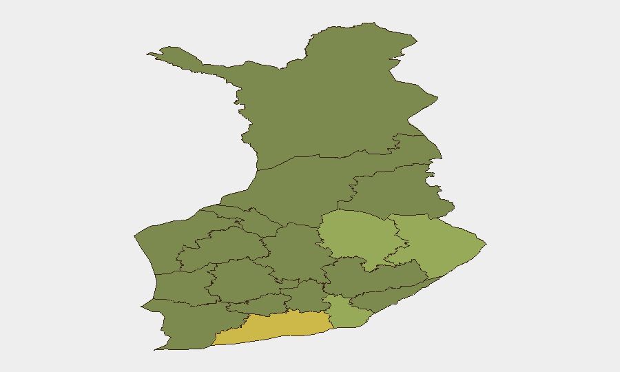
Finland remains a lower-tier global security risk (rank #157, composite score 5) but faces elevated tension along its eastern border and in the Gulf of Finland due to ongoing Russia–Ukraine military activity. Recent developments include temporary restrictions on air and maritime traffic in response to Ukrainian drone operations near St. Petersburg, alongside Russian–Finnish administrative friction over sanctions. The risk profile is concentrated in eastern and south-eastern regions proximate to the Russian border and maritime approaches.
Key Developments
- Eastern Gulf of Finland, 4 July 2026 — Finland temporarily restricted air and maritime traffic over approximately four hours as a precautionary measure following Ukrainian drone strikes near St. Petersburg, triggering heightened regional security protocols.
- Finland–Russia Border (Administrative), 2–3 July 2026 — Russian state sources reported temporary closure of railway border crossing points; Finnish administrative responses included public statements from the Ministry of Finance related to sanctions disputes, indicating ongoing bilateral friction rather than a discrete operational incident.
- South-Eastern Coast / Air Surveillance, 4 July 2026 — Finnish Defence Forces increased air surveillance along the south-eastern coast and Gulf of Finland following the brief traffic restrictions, signaling sustained monitoring posture.
- Helsinki / National Level, 3 July 2026 — Finnish government entities issued administrative statements and policy rejections connected to Russia-related sanctions and diplomatic pressure, categorized as administrative tension rather than physical security incident.
- Finland–Russia Bilateral Space, 2–3 July 2026 — Unverified social-media claims suggest Russian political and military-technical pressure responses; independent corroboration is pending and this should be monitored rather than treated as confirmed incident.
Highest-Risk Areas
Uusimaa (risk score 65), which includes Helsinki and the south-western coast, ranks as Finland's highest-risk region, driven primarily by administrative and diplomatic activity rather than direct violence. Eastern and south-eastern regions—North Karelia (44), Kymenlaakso (42), and North Savo (40)—carry elevated scores due to proximity to the Russian border and maritime approaches; these areas remain focal points for cross-border tension and surveillance activity. The eastern Gulf of Finland and border-adjacent zones show the strongest correlation with current security event signals, particularly air/maritime domain activity and administrative friction.
How GeoBit Would Assist
Security teams protecting personnel or assets in Finland should employ AOI Monitoring & Early Warning on Uusimaa, Kymenlaakso, and border-adjacent zones to detect real-time escalation in cross-border activity or restrictions. Maritime & Aviation Tracking, combined with GIS & Spatial Analysis, enable rapid identification of traffic disruptions, naval/air force movements, or maritime incidents in the Gulf of Finland. Intel Sweep and multi-language OSINT fusion provide continuous corroboration and disambiguation of Russian and Finnish administrative or military statements, reducing exposure to unverified claims.
7-Day Outlook
Near-term trajectory remains stable but contingent on Ukraine–Russia military operations proximate to St. Petersburg and the Gulf of Finland. Temporary traffic restrictions and elevated surveillance are likely to persist or recur if drone activity continues. No escalation to direct Finnish territory or physical security incidents is currently assessed, but the eastern border region and maritime zones warrant sustained monitoring and rapid-response capability.
Highest-Risk Areas — Ranked
| # | State / Region | Risk |
|---|---|---|
| 1 | Uusimaa | 65 |
| 2 | North Karelia | 44 |
| 3 | Kymenlaakso | 42 |
| 4 | North Savo | 40 |
| 5 | South Karelia | 38 |
| 6 | Kainuu | 36 |
| 7 | Päijät-Häme | 35 |
| 8 | South Savo | 32 |
| 9 | Kanta-Häme | 30 |
| 10 | Pirkanmaa | 28 |
| 11 | Central Finland | 26 |
| 12 | Southwest Finland | 25 |
Sources
Previous Daily Briefs
A new Finland brief is written every day — each with its own risk map and downloadable CSV. Here's the last week; use the calendar to go further back.
📅 Browse every day by calendar →
Highlighted days have a brief. Tap a day for that day's map & analysis, or “csv” for that day's dataset ($5).
Atlas — our AI intelligence desk — emails them this snapshot personally. Nothing else, no list.