Situation Summary
Lithuania faces elevated political and diplomatic tension as of mid-June 2026, marked by rejection of Belarusian overtures, internal coalition strain, and EU-level scrutiny. The composite threat score of 17 places Lithuania in the lower-risk band globally, but sub-national variation is significant, with Vilnius County (risk 68) accounting for the majority of tracked security signals. Military statements and cross-border investigative activity suggest heightened official concern, though the nature and severity of underlying incidents remain partially obscured by incomplete real-time intelligence. The trajectory is one of managed but visible friction rather than acute crisis.
Key Developments
- 2026-06-18, Lithuania–Belarus border: Lithuanian authorities rejected and issued administrative sanctions against Belarus, signaling a sharp diplomatic rebuff on an unspecified matter of sufficient gravity to warrant formal state action.
- 2026-06-18, Vilnius (political): Reported reduction in relations between Lithuania and its ruling coalition, indicating internal governance stress that may affect policy coherence or public-facing security messaging.
- 2026-06-18–19, Military posture: Multiple military statements issued to or regarding Lithuania over a 24-hour span, suggesting heightened readiness communication or response to external stimulus; specific operational details not yet confirmed.
- 2026-06-19, Latvia–Lithuania border: Lithuanian authorities initiated investigation linked to Latvian actors, implying a cross-border incident or concern warranting formal inquiry.
- 2026-06-19, EU–Lithuania relations: Public statement from EU institutions directed at or concerning Lithuania, indicating supranational attention to an unspecified Lithuanian matter.
- 2026-06-19, Civil/religious sector: Rabbi community issued public disapproval statement regarding Lithuanian entities, suggesting either a cultural/legal concern or minority-rights issue requiring monitoring for potential secondary civil unrest.
Assessment: The concentration of diplomatic, military, and investigative signals within 24–36 hours suggests a coordinated or cascading response to one or more triggering events; full incident details and geographic specificity remain limited by available intelligence.
Highest-Risk Areas
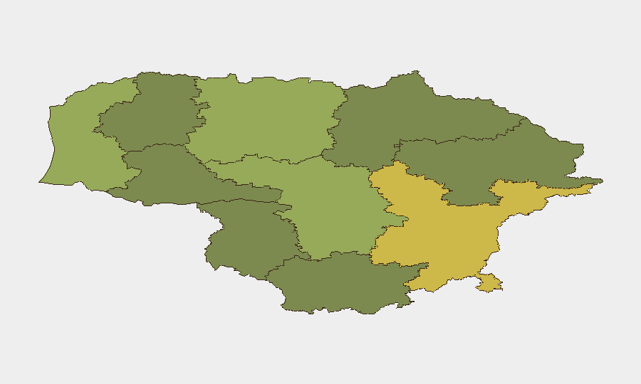
Vilnius County (risk 68) dominates the risk landscape and accounts for nearly all tracked security events, reflecting the capital's role as the seat of government, diplomatic presence, and media infrastructure. Kaunas County (risk 58) and Klaipeda County (risk 52) follow as secondary concern zones, likely reflecting regional administrative hubs and proximity to Belarus and the Baltic sea respectively. The 40-point gradient between Vilnius and lower-risk counties (Marijampole, 25) indicates that risk is highly concentrated in urban and border-proximate areas; rural interior regions show minimal tracked threat activity. Businesses and expatriate personnel should calibrate duty-of-care measures toward capital-region operations and cross-border logistics nodes.
How GeoBit Would Assist
Security teams should deploy AOI Monitoring & Early Warning with persistent alerting on Vilnius County and the Lithuania–Belarus/Latvia borders to capture emerging incidents in real time. Intel Sweep and multi-language OSINT (social, news, and official statements) provide continuous corroboration of military, diplomatic, and civil signals that are currently fragmented. Network & Actor Analysis can map relationships among ruling coalition actors, EU counterparts, and military/security leadership to anticipate cascading policy shifts or security stance changes.
7-Day Outlook
Political and diplomatic tension is likely to remain elevated through late June, with potential for further public statements from EU, NATO, or regional allies. Military posture will probably stabilize once the triggering incident is formally acknowledged or resolved, but border vigilance is expected to persist. Corporate teams should maintain heightened situational awareness in Vilnius and defer non-essential travel to border counties until diplomatic clarity improves.
Highest-Risk Areas — Ranked
| # | State / Region | Risk |
|---|---|---|
| 1 | Vilnius County | 68 |
| 2 | Kaunas County | 58 |
| 3 | Klaipeda County | 52 |
| 4 | Siauliai County | 42 |
| 5 | Panevezys County | 38 |
| 6 | Taurage County | 35 |
| 7 | Utena County | 33 |
| 8 | Alytus County | 32 |
| 9 | Telsiai County | 28 |
| 10 | Marijampole County | 25 |
Sources
Previous Daily Briefs
A new Lithuania brief is written every day — each with its own risk map and downloadable CSV. Here's the last week; use the calendar to go further back.
📅 Browse every day by calendar →
Highlighted days have a brief. Tap a day for that day's map & analysis, or “csv” for that day's dataset ($5).