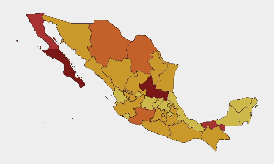
Situation Summary
Mexico's security environment has sharply deteriorated following the death of Jalisco New Generation Cartel (CJNG) leader Nemesio Oseguera Cervantes on June 2, 2026, during a Mexican Army operation in southern Jalisco. Cartel gunmen responded with coordinated violence—vehicle arson and roadblocks—across 20 states, prompting the U.S. State Department to issue shelter-in-place advisories for five states and major disruptions to civilian travel and commerce. With 1,828 tracked security events nationwide and San Luis Potosí, Baja California Sur, and Baja California ranking as highest-risk sub-national zones, Mexico remains the fifth-highest-threat country globally, driven primarily by ongoing insurgency and cartel activity.
Key Developments
- El Mencho's Death & Cartel Response (Jalisco, nationwide): Mexican Army killed CJNG leader Oseguera Cervantes near Tapalpa on June 2; cartel gunmen immediately retaliated with coordinated vehicle fires and roadblocks spanning 20 states, signaling organizational capacity and intent for further disruption.
- Jalisco Travel Disruptions (Guadalajara, Puerto Vallarta, Tapalpa): School closures across Jalisco; airline flight cancellations affecting Guadalajara and Puerto Vallarta routes; cruise operators bypassing Puerto Vallarta due to spillover violence risk from cartel operations.
- U.S. Shelter-in-Place Orders (Jalisco, Tamaulipas, Michoacán, Guerrero, Nuevo León): State Department issued formal warnings citing cartel violence and ongoing security operations; affected municipalities include Guadalajara, Puerto Vallarta, Chapala, and Reynosa.
- Northern Border Cartel Violence (Tamaulipas, Reynosa–Nuevo Laredo corridor): Armed groups conducting carjackings, kidnappings, and bus hijackings with limited law-enforcement response; heightened risk in new shelter-in-place zone reflects CJNG instability spillover potential.
- Guerrero Movement Restrictions (Acapulco, Zihuatanejo, Taxco, Ixtapa): U.S. government personnel prohibited from all movement in state due to extreme crime and kidnapping risk; reflects persistent cartel presence and organized armed-group roadblocks.
- Michoacán Limited Corridors (Morelia): U.S. government travel restricted to specific highways; heightened alert posture as CJNG and rival groups remain operationally active post-El Mencho killing.
- Quintana Roo Stability (Cancún, Playa del Carmen, Tulum, Chetumal): Situation normalized after February 22 incidents; no new restrictions in effect as of latest update.
Highest-Risk Areas
San Luis Potosí (risk score 100) and the Baja California corridor (Sur 80.4, Norte 78.2) represent the current epicenter of national threat, driven by sustained cartel territorial control and state-capacity constraints. Jalisco, while not in the top five sub-national rankings, has become operationally critical following El Mencho's death—the state now serves as a flashpoint for CJNG fragmentation and rival-cartel escalation. Northern border zones (Tamaulipas, Nuevo León, Coahuila, Chihuahua) and western states (Sinaloa, Michoacán) remain persistently elevated due to trafficking corridor competition and limited federal enforcement presence.
How GeoBit Would Assist
Teams with personnel or assets in Mexico should deploy Area-of-Interest Monitoring & Early Warning on Jalisco, Tamaulipas, and Michoacán to detect roadblock patterns and cartel movement in real time. Global event feeds and multi-language OSINT (X/Twitter, Telegram, radio SIGINT) will track cartel communications and successor-leader announcements as CJNG fragmentation likely proceeds. Routing & Network Analysis capabilities enable alternative journey planning for road-dependent supply chains and personnel movement, particularly in northern and western states where cartel checkpoints are active.
7-Day Outlook
Cartel violence is expected to remain elevated through mid-June as CJNG factions compete for leadership succession and rivals test territorial boundaries. Road travel in Jalisco, Tamaulipas, Michoacán, and Guerrero should be considered high-risk; U.S. State Department advisories will likely remain in place or expand. Domestic security operations may create secondary disruptions (checkpoints, cordons) in Guadalajara and other major cities as Mexican authorities pursue cartel leadership.
Highest-Risk Areas — Ranked
| # | State / Region | Risk |
|---|---|---|
| 1 | San Luis Potosí | 100 |
| 2 | Baja California Sur | 80.4 |
| 3 | Baja California | 78.2 |
| 4 | Tabasco | 76.1 |
| 5 | Coahuila | 75.5 |
| 6 | Michoacán | 73.6 |
| 7 | Chihuahua | 73.2 |
| 8 | Sinaloa | 72.9 |
| 9 | State of Mexico | 72.7 |
| 10 | Sonora | 72.6 |
| 11 | Guerrero | 72.6 |
| 12 | Chiapas | 72.4 |
Previous Daily Briefs
A new Mexico brief is written every day — each with its own risk map and downloadable CSV. Here's the last week; use the calendar to go further back.
📅 Browse every day by calendar →
Highlighted days have a brief. Tap a day for that day's map & analysis, or “csv” for that day's dataset ($5).