Situation Summary
Nigeria remains the fourth-highest-threat country globally, with 689 tracked security events driven primarily by active insurgency, banditry, and communal violence. The 48-hour period ending 2 June 2026 saw escalating kidnap-for-ransom operations, armed palace raids, church hostage incidents, and at least one state-level curfew imposed to counter terrorism threats. The security environment is fragmenting along geographic and sectarian lines, with rural northern and central states experiencing the most acute and sustained violence, while southern regions face political and communal instability.
Key Developments
- Kwara State palace attack (Koro, Ekiti LGA, ~1–2 June): Armed gunmen abducted the traditional ruler (Onikoro of Koro) and his son; the queen was shot. Suggests targeting of community authority figures and elevated kidnap risk in rural Kwara communities.
- Kogi State church hostage crisis (date unspecified, ongoing): Bandits holding 14 worshippers—including pastor and six children—with 48-hour 200 million naira ransom demand. Demonstrates organized kidnap-for-ransom infrastructure and acute risk to religious gatherings and institutions.
- Kogi State highway ambush (Egbe–Okoloke road, Yagba West LGA): Secondary-route bandits abducted at least one resident, reinforcing travel-corridor vulnerability and roadside kidnap threat in central Nigeria.
- Kogi State lethal raid (Idofin community): Bandits killed one person and injured another, confirming persistent armed-group presence and weak state security in rural areas.
- Adamawa State religious-service cancellations: Christian Association of Nigeria (CAN) issued credible terror-threat alert, prompting churches to cancel New Year's Eve services. Indicates elevated attack risk targeting Christian congregations and large public gatherings in the northeast.
- Northern state 24-hour curfew (state unspecified): Authorities imposed movement restrictions in support of counter-terrorism clearance operations, suggesting active military/security operations, elevated civilian risk, and potential clashes.
- South-East lethality context: Regional report cites >1,800 deaths over two years (including one monarch), evidencing sustained political/communal violence and weak state control across the southeast.
Highest-Risk Areas
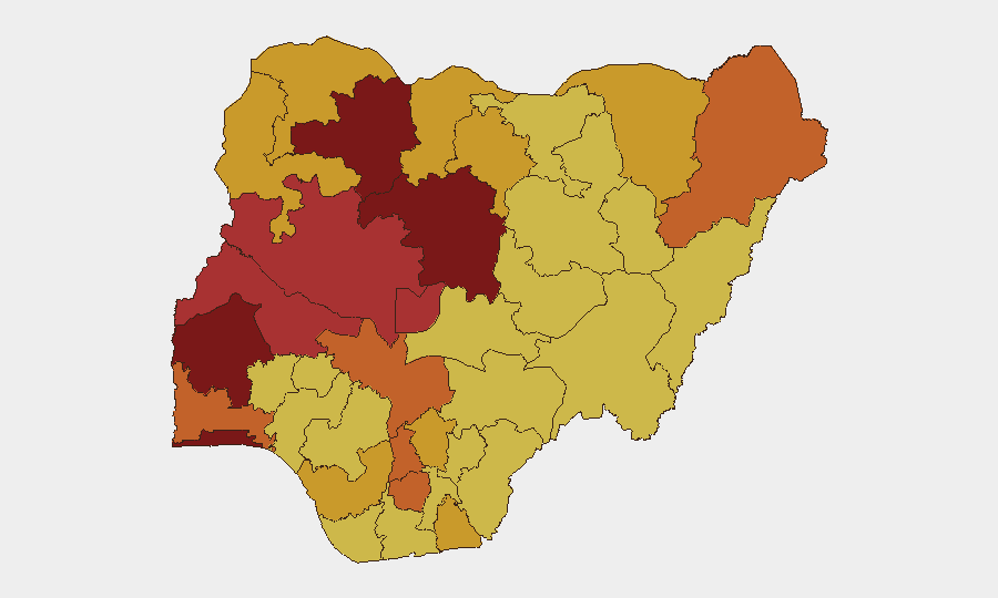
Oyo, Lagos, Zamfara, and Kaduna States comprise the top four risk-ranked jurisdictions, with composite scores of 100–83.4, reflecting a pattern of banditry, kidnap, insurgency, and communal conflict concentrated in Nigeria's north and southwest. The rapid elevation of Oyo State (rank 1, score 100) signals either recent operational escalation or significant security-intelligence correlation in the state. Kogi State's rank 12 understates the acute tactical threat revealed in the past 48 hours—multiple lethal and hostage incidents in a single state suggest either operational clustering or deteriorating state-level security capacity. Federal Capital Territory (rank 5, score 79.3) remains elevated, likely reflecting terrorism and kidnap risk on commuter routes and in periurban communities. Lagos and Ogun States rank 2 and 9 respectively, indicating sustained urban and highway crime, kidnap, and gang activity.
How GeoBit Would Assist
Security and duty-of-care teams would deploy AOI Monitoring & Early Warning to track kidnap and attack patterns in high-risk states (Kogi, Kwara, Kaduna, Adamawa); Routing & Network Analysis to identify safer travel corridors and alternative routes avoiding secondary-road ambush zones; and Intel Sweep with OSINT fusion (X/Telegram, radio SIGINT, multi-language feeds) to detect emerging ransom demands, militant communiqués, and credible threat alerts (e.g., CAN advisories) in real time.
7-Day Outlook
Kidnap-for-ransom demand cycles typically extend 2–5 days; the Kogi church hostage case will likely dominate security focus through 5–6 June, with potential for escalation or ransom negotiation. Northern curfew operations suggest active military deployments; civilian movement restrictions may persist for 3–7 days. Religious and communal gatherings in Adamawa, Kogi, and Kwara remain elevated-risk vectors through the period.
Highest-Risk Areas — Ranked
| # | State / Region | Risk |
|---|---|---|
| 1 | Oyo State | 100 |
| 2 | Lagos State | 88.4 |
| 3 | Zamfara State | 83.6 |
| 4 | Kaduna State | 83.4 |
| 5 | Federal Capital Territory | 79.3 |
| 6 | Niger State | 77.2 |
| 7 | Kwara State | 76.2 |
| 8 | Borno State | 75.9 |
| 9 | Ogun State | 75.9 |
| 10 | Imo State | 75.8 |
| 11 | Anambra State | 74.5 |
| 12 | Kogi State | 73.2 |
Previous Daily Briefs
A new Nigeria brief is written every day — each with its own risk map and downloadable CSV. Here's the last week; use the calendar to go further back.
📅 Browse every day by calendar →
Highlighted days have a brief. Tap a day for that day's map & analysis, or “csv” for that day's dataset ($5).