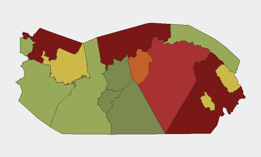
Situation Summary
Panama's composite threat score of 17 reflects a fragmented but persistent security landscape dominated by transnational crime, migration-related instability, and localized civil unrest rather than state-level conflict. The country ranks outside the global top-threat tier, but sub-national volatility—particularly in Darién, Colón, and Bocas del Toro—concentrates significant risk for expatriates, supply chains, and critical infrastructure. Recent event signals indicate elevated activity by state and non-state actors across military posturing, public statements, and arrest operations, though corroborated ground-truth reporting from the last 24–48 hours remains limited.
Key Developments
- Black Sea Maritime Incident (June 18, 2026): A Panama-flagged vessel was struck by drone attack in the Black Sea, resulting in one fatality and two injuries. Panama's Maritime Authority has issued advisories recommending avoidance of Ukrainian and Russian waters for vessels under Panamanian registry—relevant to supply chain and crew safety risk for companies with maritime operations or interests. *Location: Black Sea; impact zone: Panama City maritime authority response.*
- Arrest/Detention Activity (June 19, 2026): Federal Court action resulted in arrest or detention in Panama City, indicating ongoing law-enforcement or judicial operations. Context of subject and charges remain unclear from available sources. *Location: Panama City.*
- Blockade Event (June 19, 2026): Unconfirmed report of a blockade-type incident in Panama. Specific location and actors require additional corroboration. *Provisional event signal; source verification pending.*
- Conventional Military Activity (June 18, 20, 2026): Two distinct military-force events logged within 48 hours; statements by Panama's Ministry and government authorities suggest active government operations or posturing. Specific locations and operational scope not yet detailed in available reporting.
- Public Statements by Companies, Deputy, and Ministry (June 18–20, 2026): Multiple public statements by private-sector entities, government deputies, and ministries indicate heightened communication around security or governance issues. One Ministry statement references criminal elements. *Locations: unclear; likely Panama City-based announcements.*
- Localized Crime Reports (unconfirmed, last 48 hours): Unverified Instagram posts reference an armed robbery at a Panama City gas station and an incident at Buena Vista and 15th Street; insufficient corroboration for inclusion as confirmed events, but consistent with endemic street crime in urban areas.
Highest-Risk Areas
Darién (risk 95) remains the critical priority—a zone of weak state control, narco-trafficking, and irregular migration flows that directly threatens supply lines and personnel transit to/from Colombia. Colón (88) and Bocas del Toro (82) follow as secondary hotspots, driven by port crime, gang activity, and smuggling networks. Together, these three provinces account for a disproportionate share of violence, extortion, and kidnapping risk. Panamá Province and Panamá Oeste (78, 75) extend risk into the capital region's periphery, indicating that threat exposure is not confined to the interior but extends to residential and industrial areas near Panama City.
How GeoBit Would Assist
AOI Monitoring & Early Warning on Darién, Colón, and urban Panama City would enable near-real-time detection of movement, blockades, or unrest before they affect supply chains or personnel. OSINT Fusion (X, Telegram, local news feeds, radio SIGINT) would rapidly corroborate developing incidents and separate rumor from ground truth. Routing & Network Analysis would support alternative journey planning for staff and shipments around high-risk corridors. Maritime & Aviation Tracking would flag vessel and flight operations in relation to the Black Sea advisory and domestic transport risks.
7-Day Outlook
Near-term risk trajectory remains elevated but not sharply escalating. Military and law-enforcement activity, combined with public statements, suggests government response operations rather than breakdown of order. Monitor for any escalation in Darién-corridor incidents or announcements affecting Canal Zone transit, which would sharply raise operational risk for multinationals.
Highest-Risk Areas — Ranked
| # | State / Region | Risk |
|---|---|---|
| 1 | Darién | 95 |
| 2 | Colón | 88 |
| 3 | Bocas del Toro | 82 |
| 4 | Panamá Province | 78 |
| 5 | Panamá Oeste | 75 |
| 6 | Ngäbe-Buglé | 68 |
| 7 | Emberá-Wounaan | 62 |
| 8 | Veraguas | 58 |
| 9 | Chiriquí | 48 |
| 10 | Naso Tjër Di | 45 |
| 11 | Guna Yala | 42 |
| 12 | Coclé | 35 |
Sources
Previous Daily Briefs
A new Panama brief is written every day — each with its own risk map and downloadable CSV. Here's the last week; use the calendar to go further back.
📅 Browse every day by calendar →
Highlighted days have a brief. Tap a day for that day's map & analysis, or “csv” for that day's dataset ($5).