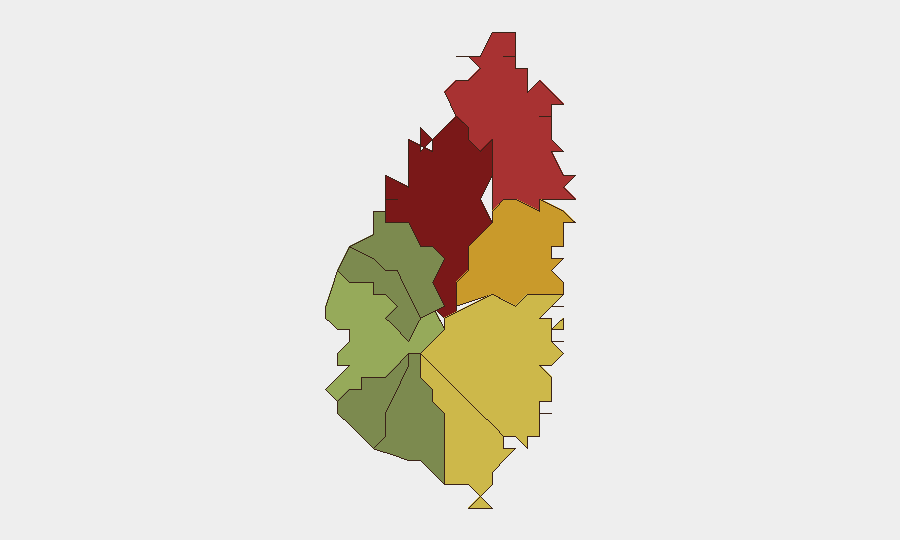
Situation Summary
Saint Lucia remains in a stable security posture with no significant, independently confirmed security incidents, civil unrest, or infrastructure failures reported in open sources over the last 24–48 hours. The composite threat score of 8 reflects baseline crime and governance pressures typical of the Caribbean region, with Castries accounting for the majority of recorded risk. No new formal travel advisories or alerts from major governments have been issued in the current reporting period.
Key Developments
No confirmed security, unrest, or infrastructure incidents specific to Saint Lucia have been reported in the last 24–48 hours via open news, official government channels, or geolocated social media.
Monitoring note: GeoBit event signals flagged several recent public statements and governance-related actions by Saint Lucia authorities (2026-06-17 to 2026-06-19), but these reflect domestic political or diplomatic activity rather than security incidents affecting corporate operations or resident safety. Verification of specific incident locations and timeframes remains pending.
Highest-Risk Areas
Castries (risk score 95) dominates the national threat profile and is the primary focus for corporate security planning. The capital concentrates gang activity, street crime, and property-related offenses, particularly in downtown commercial zones and waterfront areas. Gros Islet (78) and Dennery (72) rank second and third; both experience elevated but lower-intensity crime compared to Castries. Vieux Fort (68) and Micoud (65) represent moderate risk zones, while southern and western districts (Soufrière, Laborie, Choiseul, Anse La Raye, Canaries) remain substantially lower-risk, making them safer operational areas for personnel and asset deployment.
How GeoBit Would Assist
AOI Monitoring & Early Warning: Persistent watch on Castries, Gros Islet, and Dennery with real-time alerting on protest activity, violent incidents, or infrastructure disruption. Intel Sweep & OSINT Fusion: Daily sweep of local news outlets, Royal Saint Lucia Police Force public releases, NEMO (National Emergency Management Organisation) alerts, and social-media sentiment across X, Facebook, and local forums to detect emerging civil unrest, crime spikes, or security-service changes. Risk & Threat Assessment: Continuous synthesis of crime statistics, political climate, and event signals to flag deterioration in specific districts or changes to travel-advisory thresholds. GIS & Spatial Analysis: Mapping of incidents and risk by district to support dynamic routing and facility-location decisions for corporate teams.
7-Day Outlook
No acute security crisis is forecast for the next seven days. Baseline crime and governance monitoring should continue; attention should remain on Castries and northern districts. Hurricane season (June–November) represents a secondary, non-security threat with potential for infrastructure impact; track NEMO and regional meteorological advisories separately. Recommended action: confirm current contact rosters with local law enforcement, emergency services, and facility managers; brief on-island staff on standing crime-avoidance protocols and report-chain procedures.
Highest-Risk Areas — Ranked
| # | State / Region | Risk |
|---|---|---|
| 1 | Castries | 95 |
| 2 | Gros Islet | 78 |
| 3 | Dennery | 72 |
| 4 | Vieux Fort | 68 |
| 5 | Micoud | 65 |
| 6 | Soufrière | 42 |
| 7 | Laborie | 38 |
| 8 | Choiseul | 35 |
| 9 | Anse La Raye | 28 |
| 10 | Canaries | 12 |
Sources
Previous Daily Briefs
A new Saint Lucia brief is written every day — each with its own risk map and downloadable CSV. Here's the last week; use the calendar to go further back.
📅 Browse every day by calendar →
Highlighted days have a brief. Tap a day for that day's map & analysis, or “csv” for that day's dataset ($5).