Situation Summary
Saint Vincent and the Grenadines maintains a moderate composite threat profile (rank #null globally, score 35) with security attention currently focused on a suspected aircraft diversion linked to transnational narco-trafficking rather than on-island unrest or civil instability. Open-source reporting confirms minimal verifiable security incidents within Saint Vincent proper over the last 24–48 hours; the primary active case involves a Dominican Republic–registered light aircraft that departed Argyle International Airport on 18 June, reportedly now operating in South American airspace with transponder disabled. Law enforcement posture remains preventive and event-focused ahead of Vincy Mas 2026, with no escalation in baseline crime or political tension reported in recent hours.
Key Developments
- Argyle International Airport / South American airspace (18–19 June 2026). A light aircraft departing AIA for Tobago on 18 June is now suspected to be in South American airspace with intentional evasive maneuvers; National Security Minister St. Clair Leacock stated the aircraft is linked to suspected narco-trafficking and is being tracked by CARICOM IMPACS and Interpol. No crash in Caribbean waters has been confirmed.
- National Security Posture (19 June 2026). The Royal Saint Vincent and the Grenadines Police Force issued a preventive security advisory for Vincy Mas 2026, emphasizing zero tolerance for firearms, drugs, and violent offenses. This represents routine festival-period enforcement messaging, not response to a specific incident.
- Minister Leacock Public Statements (18–19 June 2026). Security statements referenced "recent spikes" in social-media reports of criminal activity in some communities and confirmed that heightened aviation/maritime monitoring is now in place following the aircraft diversion; overall crime trends are reported as downward.
- Regional Aviation Security (18–19 June 2026). Authorities acknowledged that aircraft diversions from SVG airspace are not unprecedented and that coordination with regional partners (Trinidad and Tobago, CARICOM) on suspicious flight monitoring has been elevated.
- No On-Island Unrest or Major Crime Events (last 24–48 hours). Open-source incident trackers confirm no verifiable new security incidents, civil unrest, arrests, or major crime events reported on-island during the reporting window.
Highest-Risk Areas
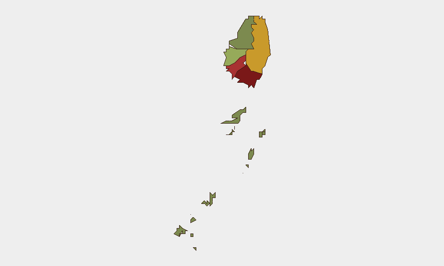
Saint George (92) and Saint Andrew (78) are the dominant risk drivers, followed by Charlotte (71), reflecting historical concentrations of organized crime, gang activity, and drug trafficking in the capital and major urban corridors. These three parishes account for the majority of reported criminal activity and are the primary focus of police enforcement. The Grenadines (12) remain the lowest-risk jurisdiction, consistent with limited population density and reduced criminal infrastructure. Risk scores correlate with urbanization and proximity to major transport hubs (ports, airports).
How GeoBit Would Assist
A corporate security team with personnel or assets in Saint Vincent would deploy AOI Monitoring & Early Warning to track developments at Argyle International Airport and maritime approaches for indicators of transnational trafficking or diversion activity; Maritime & Aviation Tracking to correlate regional flight and vessel movements with known trafficking patterns; and Intel Sweep with OSINT fusion (X/Twitter, local media, regional reporting) to detect emerging unrest, protest activity, or shifts in the crime environment ahead of festival periods. Network & Actor Analysis can profile individuals and groups linked to the aircraft case to assess secondary on-island risk.
7-Day Outlook
No escalation in on-island security incidents is forecast for the next 7 days; the aircraft diversion remains an offshore narco-trafficking matter under international monitoring. Vincy Mas 2026 will proceed under heightened police visibility and preventive enforcement. Monitor for any regional spillover from the ongoing aircraft investigation or for unexpected arrests/detentions of individuals linked to the case within SVG jurisdiction.
Highest-Risk Areas — Ranked
| # | State / Region | Risk |
|---|---|---|
| 1 | Saint George | 92 |
| 2 | Saint Andrew | 78 |
| 3 | Charlotte | 71 |
| 4 | Saint Patrick | 58 |
| 5 | Saint David | 34 |
| 6 | Grenadines | 12 |
Sources
Previous Daily Briefs
A new Saint Vincent brief is written every day — each with its own risk map and downloadable CSV. Here's the last week; use the calendar to go further back.
📅 Browse every day by calendar →
Highlighted days have a brief. Tap a day for that day's map & analysis, or “csv” for that day's dataset ($5).