Situation Summary
Sierra Leone remains a moderate-risk jurisdiction (global rank #51, composite score 5.4) with acute vulnerabilities concentrated in the Eastern Province and elevated governance pressures in the Western Area. Recent police action against media, alleged high-level involvement in transnational drug trafficking, and potential EU aid suspension signal deteriorating state-institution credibility and civil-liberty constraints. Security risks are primarily urban (opportunistic crime in Freetown), infrastructure-dependent (power/water/comms failures), and geographically patterned (Eastern Province instability; night-time road hazards outside the peninsula; unofficial roadblocks on beach routes).
Key Developments
- Freetown, 2 June – press freedom incident: Police raided the *Voice of Salone* newspaper office and detained the editor for questioning over a narco-trafficking exposé implicating senior officials and port security. Signals erosion of media independence and potential political pressure on investigative journalism.
- EU-level governance escalation: The Dutch government is drafting a European Parliament motion to suspend development aid and explore military-action options, citing alleged presidential complicity in cocaine trafficking. Reflects upstream diplomatic risk and potential for coordinated international pressure on the regime.
- Freetown crime hotspots: Robberies at knifepoint and muggings have been reported in Congo Cross, Wilkinson Road, Lumley Beach, and Aberdeen; beach resorts remain targets for opportunistic crime against both locals and expatriates.
- Western Area roadblock risk: Unofficial checkpoints on routes to tourist beaches, particularly weekends, pose robbery and extortion hazards under false-authority pretences.
- Countrywide governance pressure: Police violence against demonstrators, assembly restrictions, and pervasive corruption indicate sustained risk of politically-linked unrest and heavy-handed security responses across all regions.
- Road-travel safety degradation: UK guidance prohibits travel outside the Freetown peninsula after nightfall due to poor vehicle standards, unlit roads, erratic driving, and accident hazards.
- Land-border volatility: Guinea and Liberia borders are staffed with security personnel; paperwork delays and short-notice closures are possible, indicating regional instability.
- Infrastructure fragility: Unreliable electricity, frequent outages, limited mains water, and patchy mobile coverage compound emergency-response complexity and business continuity risk nationally.
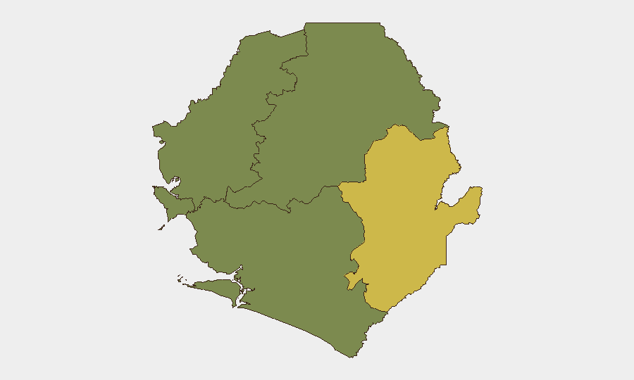
Highest-Risk Areas
Eastern Province dominates the sub-national threat picture (risk score 68), indicating entrenched security challenges—likely linked to porous borders, organized crime networks, and limited state capacity. The Western Area (risk 35), anchored by Freetown, presents secondary but acute hazards: urban crime, political tension, media suppression, and ad-hoc enforcement actions against civilian and commercial targets. Northern, North West, and Southern provinces register no tracked current events, but should not be assumed secure; limited monitoring coverage and infrastructure gaps may obscure underlying risks. Security incidents in Eastern Province and Freetown are most likely to escalate or cascade.
How GeoBit Would Assist
Teams with people or assets in Sierra Leone should deploy AOI Monitoring & Early Warning on Freetown (media/police activity, street-level crime), Eastern Province border zones, and beach-route roadblocks to detect escalation in real time. Intel Sweep (global event feeds, X/Telegram OSINT, multi-language search) and Network & Actor Analysis enable tracking of narco-trafficking allegations, EU diplomatic moves, and regime-stability indicators. Routing & Network Analysis supports safe-passage planning by identifying alternative routes and timing strategies to avoid night travel and roadblock hotspots.
7-Day Outlook
Diplomatic pressure from the EU and Dutch government will likely intensify, potentially triggering regime defensive posturing and further restrictions on civil liberties and media. Freetown crime and roadblock incidents are expected to persist. No imminent outbreak of organized violence is signaled, but governance friction and transnational narco-trafficking scrutiny create an unstable backdrop for business continuity and duty-of-care compliance.
Highest-Risk Areas — Ranked
| # | State / Region | Risk |
|---|---|---|
| 1 | Eastern Province | 68 |
| 2 | Western Area | 35 |
| 3 | North West Province, Sierra Leone | 0 |
| 4 | Northern Province, Sierra Leone | 0 |
| 5 | Southern Province, Sierra Leone | 0 |
Previous Daily Briefs
A new Sierra Leone brief is written every day — each with its own risk map and downloadable CSV. Here's the last week; use the calendar to go further back.
📅 Browse every day by calendar →
Highlighted days have a brief. Tap a day for that day's map & analysis, or “csv” for that day's dataset ($5).