Situation Summary
Sudan's civil war continues to deteriorate rapidly, with the Sudanese Armed Forces (SAF) losing territorial control to the Rapid Support Forces (RSF) across multiple fronts. The loss of al-Fashir in North Darfur on 2 June—the SAF's last major stronghold in the region—represents a critical inflection point in the conflict and has triggered emergency UN Security Council engagement. The humanitarian situation is now acute, with millions displaced, essential services collapsing nationwide, and atrocity warnings from UN officials. The conflict trajectory remains severely degraded and unpredictable, with violence escalating across Darfur, Blue Nile, and urban centers including Khartoum.
Key Developments
- al-Fashir, North Darfur (2–3 June): SAF loss of al-Fashir to RSF control eliminates the army's last operational stronghold in Darfur and opens terrain for RSF consolidation across the western region.
- UN Emergency Session (2–3 June): UN Security Council convened in emergency response to al-Fashir's fall; briefers reported escalating civilian atrocities, killing, and sexual violence across Darfur.
- Humanitarian access crisis (ongoing): UN staff report inability to scale operations around al-Fashir and wider Darfur without security guarantees; aid pipeline severely constrained across Sudan.
- Flooding and displacement (3 June): Heavy rains triggered emergency humanitarian response; over 13,000 families affected, with shelter and supplies already critically short.
- Infrastructure collapse (national, ongoing): Essential services degrading rapidly; fuel, water, health, and communications systems failing across the country.
- Blue Nile volatility (February–present): Renewed clashes and escalation risk in Blue Nile State indicate conflict spread beyond Darfur; RSF and SAF activity remains unpredictable.
- Cross-border tensions (2–3 June): Public statements from Rwanda and rejections from South Sudan signal regional diplomatic friction; border stability cannot be assumed.
Highest-Risk Areas
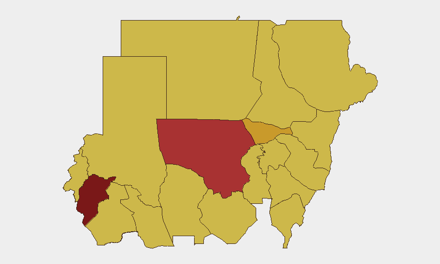
Central Darfur (risk 100) and North Kordofan (78.8) remain the epicenter, driven by active RSF consolidation, SAF collapse, and documented civilian targeting. Al Khartum (72.7) presents acute urban risk tied to supply shortages, service failure, and residual SAF–RSF contact. The tier-two band of states—Blue Nile, River Nile, Al Jazira, Red Sea, Al Qadarif, Kassala, Sennar, South Darfur, and West Kordofan (all 70)—reflects dispersed conflict activity, displacement corridors, and humanitarian access denial. This distribution signals the conflict is no longer regional but nationwide; organizations with footprint across Sudan face compounding exposure.
How GeoBit Would Assist
Teams should deploy AOI monitoring and early warning on high-risk state capitals (al-Fashir, En Nahud, Khartoum, Kassala) to track force movement, displacement flows, and service disruption in real time. Conflict and military analysis—force structure, battle mapping, and weapons-capability tracking—enables tactical understanding of RSF vs. SAF positioning and likely next moves. Routing and network analysis provides alternative journey and supply-chain planning for personnel and assets, with live re-routing as access corridors close.
7-Day Outlook
RSF consolidation in Darfur will likely accelerate; expect announcements of territorial claims and further SAF redeployments from the west. Humanitarian access will remain severely degraded, with displacement pressures increasing into Central African Republic and Chad. Urban violence and service collapse in Khartoum and secondary cities will intensify, raising risk for international staff and supply chains.
Highest-Risk Areas — Ranked
| # | State / Region | Risk |
|---|---|---|
| 1 | Central Darfur State | 100 |
| 2 | North Kordofan State | 78.8 |
| 3 | Al Khartum | 72.7 |
| 4 | Blue Nile | 70 |
| 5 | River Nile State | 70 |
| 6 | Aj Jazira | 70 |
| 7 | Red Sea State | 70 |
| 8 | Al Qadarif State | 70 |
| 9 | Kassala State | 70 |
| 10 | Sennar State | 70 |
| 11 | South Darfur State | 70 |
| 12 | West Kurdufan State | 70 |
Sources
Previous Daily Briefs
A new Sudan brief is written every day — each with its own risk map and downloadable CSV. Here's the last week; use the calendar to go further back.
📅 Browse every day by calendar →
Highlighted days have a brief. Tap a day for that day's map & analysis, or “csv” for that day's dataset ($5).