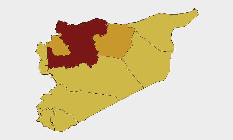
Situation Summary
Syria remains in a state of fragmented conflict with no unified governance, driving a composite threat score of 100 and ranking #7 globally. The security environment is characterized by simultaneous threats across multiple domains: Israeli border operations and incursions in the south; ISIS insurgency and sleeper-cell activity in the east and southeast; sectarian tensions and armed-group activity; and large-scale displacement creating humanitarian and criminal-activity vacuums. The trajectory remains volatile with no near-term stabilization indicators.
Key Developments
- Southern Syria border incidents (Daraa, Quneitra). An unarmed shepherd was wounded by Israeli fire near the occupied Golan; an Israeli ground unit conducted a one-hour incursion into Quneitra; Israel has imposed an undeclared buffer zone restricting movement and agricultural access in border communities, raising livelihood and livelihood-disruption risks.
- ISIS attacks in Deir ez-Zor. Multiple coordinated ISIS attacks targeted SDF checkpoints, vehicles, and military posts; the SDF and US-led coalition responded with a joint raid and arrested a senior ISIS emir, but the frequency and coordination of attacks signal ISIS capability rebuilding in the east.
- Execution of US citizen in Suwayda. Armed assailants wearing Syrian army and General Security uniforms (some bearing ISIS insignia) raided the home of US citizen Hussam Saraya and executed him, raising concerns about state-force impersonation, ISIS infiltration of uniformed services, and possible collusion or security-force compromise.
- Radicalization and sleeper-cell indicators. Pro-ISIS slogans were painted on a girls' school wall in Daraa; intelligence reports note ISIS is actively seeking to rebuild clandestine networks in northeast and eastern Syria following recent counterterrorism disruptions.
- Large-scale southern displacement. The UN reports approximately 176,000 people displaced from southern Syria due to deteriorating security and humanitarian conditions, creating ungoverned spaces and elevated risks for crime, civil unrest, and militant recruitment.
- Infrastructure disruption (Euphrates flooding). While water levels have begun to ease in Deir ez-Zor and some services are being restored, the earlier flood wave destroyed three bridges in Iraq's al-Qaim, underscoring regional logistics vulnerabilities and cross-border infrastructure interdependencies.
- Amnesty International investigations and arrests. Amnesty International investigations into alleged physical assaults and arrests by Syrian authorities on 2026-06-01; Germany has also conducted arrest/detention actions involving Syrians, indicating ongoing judicial and human-rights scrutiny of state conduct.
Highest-Risk Areas
Damascus Governorate (risk 100) and Hama Governorate (96.7) face the highest composite risk due to continued state and non-state armed activity, contested governance, and proximity to active conflict zones. Aleppo (83.4) remains a flashpoint for military operations and displacement. Southern governorates—Daraa, Al-Quneitra, and Lattakia (all risk 70)—face acute border volatility driven by Israeli incursions, buffer-zone restrictions, and ISIS sleeper-cell activity. Eastern zones (Ar-Raqqa, Deir ez-Zor at 71.1 and 70.4) remain contested between SDF control and ISIS insurgency. The UNDOF buffer zone (risk 70) reflects the inherent instability of the Israeli–Syrian ceasefire line.
How GeoBit Would Assist
Security teams should employ AOI Monitoring & Early Warning to track incident density and timing patterns in Damascus, Daraa, and Deir ez-Zor; Intel Sweep and OSINT fusion to corroborate reports of ISIS infiltration, state-force impersonation, and clandestine recruitment; Conflict & Military battle mapping and Network & Actor Analysis to monitor Israeli incursion patterns, SDF-ISIS tactical exchanges, and armed-group movements; and Routing & Network Analysis to identify safe transit corridors away from buffer zones and active military activity zones for personnel and supply movements.
7-Day Outlook
Border tensions along the Israeli–Syrian frontier will likely remain elevated with continued localized incursions and civilian-impact incidents. ISIS insurgent activity in Deir ez-Zor and Daraa is expected to persist despite coalition pressure, with sleeper-cell activation a near-term risk. Displacement flows and humanitarian deterioration will continue to degrade state capacity and create ungoverned spaces conducive to militant activity.
Highest-Risk Areas — Ranked
| # | State / Region | Risk |
|---|---|---|
| 1 | Damascus Governorate | 100 |
| 2 | Hama Governorate | 96.7 |
| 3 | Aleppo Governorate | 83.4 |
| 4 | Idleb Governorate | 71.1 |
| 5 | Ar-Raqqa Governorate | 71.1 |
| 6 | Deir ez-Zor Governorate | 70.4 |
| 7 | Lattakia Governorate | 70 |
| 8 | Tartus Governorate | 70 |
| 9 | UNDOF | 70 |
| 10 | Al-Quneitra Governorate | 70 |
| 11 | Dar'a Governorate | 70 |
| 12 | Homs Governorate | 70 |
Previous Daily Briefs
A new Syria brief is written every day — each with its own risk map and downloadable CSV. Here's the last week; use the calendar to go further back.
📅 Browse every day by calendar →
Highlighted days have a brief. Tap a day for that day's map & analysis, or “csv” for that day's dataset ($5).