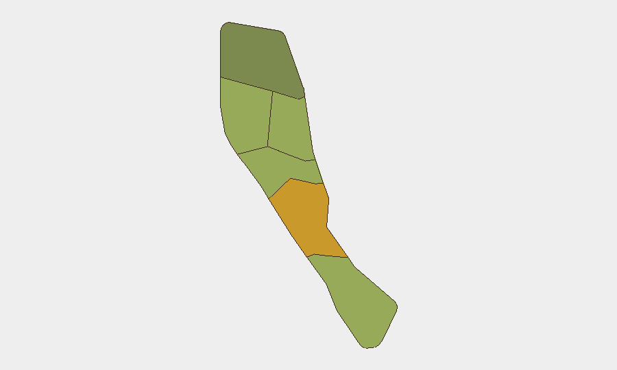
Situation Summary
Vanuatu remains a low-threat environment globally (composite score 2) but faces elevated regional tension following diplomatic friction with France and New Caledonia as of 11 June 2026. Shefa Province, home to the capital Port Vila, carries the highest sub-national risk (72), driven by administrative density and economic activity rather than active conflict. Recent seismic activity (M 5.0 near Isangel, M 4.5 near Port-Olry) adds natural-hazard exposure typical of the archipelago's volcanic and tectonic setting.
Key Developments
- 11 June 2026 · Diplomatic Tension (National): Vanuatu issued multiple public statements of disapproval toward France and announced a reduction in relations with New Caledonia. The specific triggers and policy implications remain limited in open reporting; escalation or sanctions remain possible but unconfirmed.
- Recent · Seismic Events (Multiple Locations): A magnitude 5.0 earthquake struck approximately 68 km north-northwest of Isangel (Tafea); a M 4.5 event occurred 35 km east of Port-Olry (Penama). No casualty or infrastructure-damage reports have been corroborated in available sources. Standard volcanic-zone aftershock patterns apply.
Note on 24–48 Hour Coverage: Open-source web search (including major social platforms and news indices) has not corroborated additional security, civil-unrest, crime, or infrastructure incidents in Vanuatu during the 24–48 hours prior to this brief. Older reports on ongoing operations (e.g., "Operation Port Vila Reset 2026") exist but lack recent time stamps sufficient to classify as current developments.
Highest-Risk Areas
Shefa Province dominates Vanuatu's risk profile (72) due to Port Vila's role as the administrative and commercial hub, concentrating population, foreign residents, diplomatic presence, and economic infrastructure. Penama (58) and Sanma (52) follow, likely reflecting maritime-boundary sensitivities, inter-island trade friction, and demographic density. Tafea (45) and Torba (35) carry lower composite scores but remain subject to seismic hazard and isolation-driven service-delivery gaps. The recent diplomatic row with France and New Caledonia may create secondary risks in Shefa and coastal Penama if economic or supply-chain disruptions occur.
How GeoBit Would Assist
AOI Monitoring & Early Warning would establish persistent watch on Port Vila, key island ports, and provincial administrative centers to detect civil unrest, infrastructure damage, or irregular security activity in real time. Conflict & Military and Network & Actor Analysis capabilities would track diplomatic and factional rhetoric on social platforms (X, Telegram, local radio) and entity relationships among government, opposition, and French/New Caledonian officials to forecast escalation vectors. Environmental & Health and Satellite & Imagery Analysis would correlate seismic data with infrastructure vulnerability and port/runway operability to support duty-of-care assessments and evacuation routing.
7-Day Outlook
The Franco-Vanuatu diplomatic friction is unlikely to generate kinetic security incidents in the near term but may trigger targeted economic measures, visa restrictions, or supply-chain delays affecting corporate operations and expatriate movement. Seismic activity is consistent with normal regional hazard; no volcanic or tsunami alerts are currently broadcast. Monitoring should remain heightened on Shefa Province for any ripple effects from the diplomatic dispute and on maritime zones for potential maritime-boundary or fishing-rights enforcement activity.
Highest-Risk Areas — Ranked
| # | State / Region | Risk |
|---|---|---|
| 1 | Shefa Province | 72 |
| 2 | Penama | 58 |
| 3 | Sanma | 52 |
| 4 | Malampa | 48 |
| 5 | Tafea | 45 |
| 6 | Torba | 35 |
Sources
Previous Daily Briefs
A new Vanuatu brief is written every day — each with its own risk map and downloadable CSV. Here's the last week; use the calendar to go further back.
📅 Browse every day by calendar →
Highlighted days have a brief. Tap a day for that day's map & analysis, or “csv” for that day's dataset ($5).