Situation Summary
Grenada remains in a low-threat environment with a composite threat score of 12 globally and no credible security incidents documented in the last 24–48 hours. Open-source monitoring across regional news outlets, social media, and official channels shows an absence of acute civil unrest, violent-crime spikes, or infrastructure disruptions affecting the general population or business operations. The security landscape is stable but localized crime—particularly in Saint George—remains an underlying persistent concern warranting operational awareness for personnel and assets in high-risk parishes.
Key Developments
- No acute incidents detected (24–48h window). Regional security monitoring, Caribbean news aggregators, and social-media feeds (including X/Twitter and local Grenada outlets) show no corroborated reports of shootings, protests, political instability events, or major service disruptions as of 22 July 2026.
- Routine crime baseline continues. A shooting incident near the NAWASA reservoir in South Saint George (Jean Anglais area) was documented several days prior to the current reporting window; no new incidents of similar severity have been reported in the last 48 hours.
- Regional stability supports Grenada outlook. Neighboring islands (Saint Vincent, Barbados) show no acute security or civil-unrest events in the last 24–48 hours, indicating low cross-border spillover risk and a stable regional operating environment.
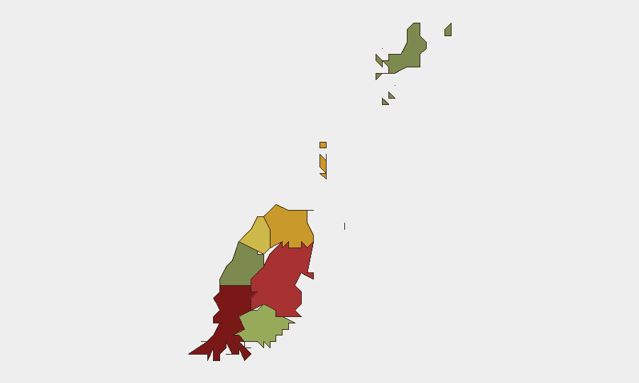
Highest-Risk Areas
Saint George (risk score 92) is the dominant risk driver, reflecting persistent localized street crime and gang-related violence, particularly in South Saint George parishes and densely populated urban zones. Saint Andrew (78) and Saint Patrick (71) show elevated but secondary risk profiles, likely driven by economic marginalization and associated property and violent crime. By contrast, Carriacou and Petite Martinique (12) remain materially safer, as does Saint John (38), making them lower-priority areas for acute monitoring. Security teams should concentrate duty-of-care resources and incident-monitoring protocols on Saint George and, secondarily, Saint Andrew, while maintaining standard baseline awareness in outer parishes.
How GeoBit Would Assist
Security and risk teams operating in Grenada should deploy AOI Monitoring & Early Warning on high-risk parishes (especially Saint George) to generate real-time alerts for new violent-crime incidents, arrests, or civil disturbances. Intel Sweep combined with OSINT fusion (X/Twitter, local news, police bulletins, and regional feeds) enables 24/7 corroboration of rumors and early detection of emerging threats before they escalate to operational impact. Risk & Threat Assessment modules can maintain dynamic personnel and asset vulnerability profiles linked to sub-national risk rankings, automating duty-of-care reporting and enabling rapid response protocols if risk scores shift materially.
7-Day Outlook
No acute escalation is forecast over the next seven days; Grenada's threat environment is expected to remain stable and low-intensity, with routine street crime as the primary operational consideration. Security teams should maintain standard monitoring cadence and keep communication channels with local law enforcement and business peers active to detect any early signals of change. If political, weather, or regional developments occur, GeoBit's platform will flag them immediately through persistent monitoring and event correlation.
Highest-Risk Areas — Ranked
| # | State / Region | Risk |
|---|---|---|
| 1 | Saint George | 92 |
| 2 | Saint Andrew | 78 |
| 3 | Saint Patrick | 71 |
| 4 | Saint Mark | 64 |
| 5 | Saint David | 52 |
| 6 | Saint John | 38 |
| 7 | Carriacou and Petite Martinique | 12 |
Sources
Previous Daily Briefs
A new Grenada brief is written every day — each with its own risk map and downloadable CSV. Here's the last week; use the calendar to go further back.
📅 Browse every day by calendar →
Highlighted days have a brief. Tap a day for that day's map & analysis, or “csv” for that day's dataset ($5).
Atlas — our AI intelligence desk — emails them this snapshot personally. Nothing else, no list.