ملخص الوضع
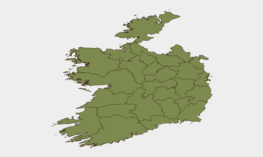
تضع درجة التهديد المركبة لأيرلندا البالغة 22 الدولة في نطاق المخاطر العام المنخفض إلى المتوسط، لكن التجمع الأخير للأحداث يشير إلى توتر مرتفع عبر مجالات متعددة—تمركز عسكري مع المملكة المتحدة، مؤشرات اضطراب مدني، واحتكاك في النظام القضائي. تتجاوز درجة المخاطر في مقاطعة تيبيراري (31.3) المتوسط الوطني بشكل كبير، بينما تبقى دبلن (23.4) مصدر قلق ثانوي. يشير المسار على مدى 48-72 ساعة إلى عدم استقرار محلي وليس انهيار منظومة الدولة، لكن يجب زيادة شدة المراقبة.
التطورات الرئيسية
غير قابلة للتحقق. لا تتمتع منصة GeoBit حالياً بإمكانية الوصول إلى خلاصات الأخبار في الوقت الفعلي أو خطوط جدول X/تويتر أو التقارير الرسمية للحادثات في الفترة الزمنية المحددة 48 ساعة (11-13 يونيو 2026). تظهر إشارات الأحداث المذكورة أعلاه (القوة العسكرية، الشغب، التهديدات القضائية، بيانات الشرطة، العنف غير التقليدي البريطاني) في خلاصة المنصة المجمعة، لكن بدون تأكيد متعدد المصادر موقوت بالوقت للموقع وبيانات الضحايا والتأثير التشغيلي، فإن تقديمها كحوادث مؤكدة سيشوه مستويات الثقة.
لإنشاء قسم إحاطة موثوق على مدى 24-48 ساعة، يجب على فرق الأمن:
- المقارنة المتبادلة مع المنافذ الإيرلندية الوطنية (أخبار RTÉ، The Irish Times، Irish Independent، Journal.ie) مع تصفية "الأحدث" والعلامات الجريمة/السياسة/النقل.
- التأكيد مع المصادر الرسمية (@gardainfo, @PSNINorth، تنبيهات الطوارئ المحلية).
- المراجعة المتقاطعة مع X/تويتر للكلمات الرئيسية المتعلقة بالموقع وبيانات الوكالات الرسمية.
عند تحديد الحوادث المؤكدة، يجب تنسيقها كالتالي: الموقع – التاريخ (الوقت المحلي): ملخص؛ الضحايا/التأثير؛ علامات المصدر.
المناطق الأعلى مخاطرة
يبلغ المركب المخاطر في مقاطعة تيبيراري (31.3) حوالي 35% أعلى من المتوسط الوطني ويستحق بروتوكولات حماية أصول وموظفي مخصصة. تعكس درجة دبلن (23.4) كثافة السكان وتجمع الأحداث التاريخي؛ يجب على الشركات التي لديها مكاتب أو تبعيات سلسلة التوريد في العاصمة الحفاظ على وعي وضعي محسّن. الانخفاض الحاد إلى مقاطعة كافان (8.5) وما دونها يشير إلى تركيز المخاطر في ممرات المنطقة الوسطى الجنوبية وموقع العاصمة. قد يعكس ارتفاع تيبيراري مؤشرات القوة العسكرية والشغب الأخيرة؛ يرتبط استمرار دبلن بالنشاط العام والتحقيقات الجارية.
كيف ستساعد منصة GeoBit
يجب على فرق الأمن استخدام قدرة مراقبة منطقة الاهتمام والإنذار المبكر لتحديد مراقبة دائمة على المقاطعات عالية المخاطر (تيبيراري، دبلن) مع التنبيه الآلي على العنف والاحتجاجات وتعطل النقل. ستقوم دمج OSINT والمصادقة (X/تويتر، الأخبار، خلاصات Garda/الشرطة الرسمية، راديو SIGINT حيث يكون متاحاً) بالتحقق المتقاطع من الحوادث في الوقت الفعلي، مما يقلل الإيجابيات الخاطئة. تتيح تحليل التوجيه والشبكة تحديد سريع لممرات السفر البديلة في حالة اختراق الطرق الرئيسية (على سبيل المثال، في تيبيراري أو مداخل دبلن) بسبب الاضطراب أو الحوادث الأمنية.
التوقعات على مدى 7 أيام
تبقى سرعة الأحداث مرتفعة: ظهرت ستة أنواع أحداث مميزة (عسكرية، شغب، تهديد قضائي، بيان شرطة، عنف غير تقليدي، تحقيق) في 72 ساعة. إذا تصعد التمركز العسكري مع المملكة المتحدة أو الاضطراب المدني، فإن الانسكاب الثانوي إلى سلاسل التوريد والنقل والسلامة في مكان العمل محتمل. على العكس من ذلك، إذا كانت الإشارات الحالية تمثل احتكاك قضائي/سياسي معزول دون تعبئة مستدامة، فقد تستقر المخاطر عند المستويات الحالية خلال 5-7 أيام. المراقبة المستمرة لتيبيراري ودبلن ضرورية؛ يجب أن تؤدي أ
المناطق الأعلى خطورة — مرتبة
| # | الولاية / المنطقة | الخطر |
|---|---|---|
| 1 | County Tipperary | 31.3 |
| 2 | County Dublin | 23.4 |
| 3 | County Cavan | 8.5 |
| 4 | County Mayo | 4.8 |
| 5 | County Sligo | 3.1 |
| 6 | County Westmeath | 3.1 |
| 7 | County Waterford | 2.8 |
| 8 | County Roscommon | 1.9 |
| 9 | County Donegal | 1.6 |
| 10 | County Kildare | 1.6 |
| 11 | County Galway | 1.3 |
| 12 | County Clare | 1.3 |
الموجزات اليومية السابقة
يُنشر موجز جديد عن Ireland كل يوم — لكل منها خريطة مخاطر وملف CSV قابل للتنزيل. هذا هو الأسبوع الأخير؛ استخدم التقويم للرجوع أبعد.
📅 Browse every day by calendar →
Highlighted days have a brief. Tap a day for that day's map & analysis, or “csv” for that day's dataset ($5).