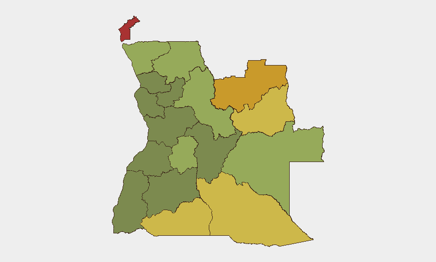
Situation Summary
Angola remains a low-to-moderate global security risk (#65 globally, composite score 33) with no tracked security incidents in the past 24–48 hours. The country's threat profile is heavily concentrated in resource-rich border provinces—particularly Cabinda, Lunda Norte, and Lunda Sul—where competition over diamonds, land, and governance has historically driven localized instability. Current conditions show no acute deterioration, though structural vulnerabilities in remote eastern and northeastern regions persist.
Key Developments
No verifiable security or unrest events were identified in Angola within the last 24–48 hours. Available open-source reporting (Angola24Horas, Novo Jornal, ANGOP, international travel advisories, and monitored social-media feeds) returned no time-stamped incidents meeting corroboration standards for this brief. The most recent trackable signals are wildfire events across central and eastern Angola (ongoing since early June), which pose secondary risks to transportation, air quality, and supply-chain continuity but do not themselves constitute security incidents.
Duty-of-care teams should note that absence of reported events does not indicate absence of risk; rather, Angola's highest-risk provinces (listed below) remain under-reported by international media, and localized incidents (roadblocks, small-scale protests, labor actions, crime) may not surface in real time.
Highest-Risk Areas
Cabinda Province (risk 78) and Lunda Norte Province (risk 72) are the dominant drivers of Angola's sub-national risk profile. Cabinda's elevated score reflects long-standing separatist sentiment, oil-industry labor disputes, and competition for petroleum revenue; Lunda Norte's score reflects artisanal and industrial diamond-mining conflicts, limited state presence, and cross-border movement of armed groups. Lunda Sul (68), Cuando Cubango (64), and Cunene (62) follow, all characterized by porous borders with the Democratic Republic of Congo and Namibia, informal mining networks, and weak law-enforcement capacity. In contrast, central urban zones (Luanda, Benguela, Huambo) carry substantially lower risk scores, reflecting state security concentration and commercial infrastructure. Organizations with assets or personnel in the top five provinces should implement heightened due diligence and maintain direct local security liaison.
How GeoBit Would Assist
Persistent Area-of-Interest Monitoring & Early Warning (AOI Watch) configured for Cabinda, Lunda Norte, and Lunda Sul would generate alerts on protest activity, roadblocks, and armed-group movements before they affect operations or travel routes. Multi-language Intel Sweep and X/Twitter/Telegram OSINT targeted at local journalists, mining operators, and civil-society monitors would capture sub-national incidents (labor actions, supply disruptions, security incidents) often missed by international press. Network & Actor Analysis and Conflict Mapping would track key stakeholders (government, separatist movements, mining syndicates, armed groups) and their operational patterns to enable predictive positioning of personnel and assets.
7-Day Outlook
No significant security escalation is anticipated in the near term. Seasonal wildfire activity will likely persist through late June, creating air-quality and transport disruptions but not security events. The operational environment in high-risk provinces remains structurally volatile but stable at current baseline; organizations should maintain standard protective posture and prepare for routine labor, border-crossing, and supply-chain friction rather than acute crisis.
Highest-Risk Areas — Ranked
| # | State / Region | Risk |
|---|---|---|
| 1 | Cabinda Province | 78 |
| 2 | Lunda Norte Province | 72 |
| 3 | Lunda Sul Province | 68 |
| 4 | Cuando Cubango Province | 64 |
| 5 | Cunene Province | 62 |
| 6 | Moxico Province | 58 |
| 7 | Zaire Province | 54 |
| 8 | Huambo Province | 50 |
| 9 | Uíge Province | 48 |
| 10 | Malanje Province | 42 |
| 11 | Bié Province | 35 |
| 12 | Huíla Province | 32 |
Sources
Previous Daily Briefs
A new Angola brief is written every day — each with its own risk map and downloadable CSV. Here's the last week; use the calendar to go further back.
📅 Browse every day by calendar →
Highlighted days have a brief. Tap a day for that day's map & analysis, or “csv” for that day's dataset ($5).