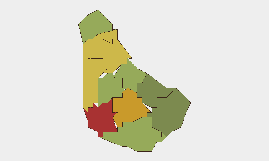
Situation Summary
Barbados remains a low-threat environment globally (rank #137; composite score 2.6), with no confirmed security incidents, civil unrest, or significant travel disruptions reported in the last 24–48 hours. Two tracked events registered on 2026-06-28 (a rejection notice and a public statement involving the Ministry of Home Affairs), but no corroborated incident details are available through open-source channels. The security posture is stable; routine infrastructure and weather management are the primary operational concerns.
Key Developments
No substantive incident-based developments confirmed in the last 24–48 hours. Open-source reporting and social media monitoring (news sites, regional media, X/Twitter) for June 26–28, 2026, return only routine community events, weekly weather digests, and regional (non-Barbados) police operations. A Barbados Today reference to heavy rainfall and potential low-lying-area flooding appears in weekly roundup content but lacks a specific time-stamp, precise location, or independent corroboration. The two platform-tracked events (rejection and public statement, both dated 2026-06-28) require additional source verification to determine operational relevance. No confirmed spikes in violent crime, political instability, infrastructure failure, or travel warnings have been identified.
Highest-Risk Areas
Saint Michael (risk 78) and Saint George (risk 72) drive the sub-national risk profile, likely reflecting Bridgetown's urban density, port activity, and higher concentrations of transient populations—typical friction points in Caribbean island economies. Saint James (68) and Saint Andrew (65) follow, representing secondary urban/commercial corridors where property crime and organized-activity monitoring are routine. Lower-risk parishes (Saint Philip, 28; Saint John, 35) suggest risk is concentrated in the northwest and central regions; corporate and diplomatic assets in or near Bridgetown warrant standard due-diligence protocols but do not indicate acute threat escalation.
How GeoBit Would Assist
A security team with personnel or assets in Barbados would deploy AOI Monitoring & Early Warning on Saint Michael and Saint George parishes to detect emerging civil unrest, crime spikes, or infrastructure disruptions in real time. Intel Sweep and X/Twitter & Telegram OSINT with temporal and sentiment analysis would distinguish routine community chatter from early-warning signals of labor actions, political protests, or criminal incidents. Alternative Route & Network Analysis would support duty-of-care evacuation and commute planning if localized disruptions develop; baseline route mapping in high-risk parishes is prudent for any organization with regular personnel movement in Bridgetown or surrounding areas.
7-Day Outlook
No acute escalation is forecast. Weekly weather monitoring (heavy rainfall potential in low-lying areas) remains a standard operational concern rather than a security emergency. The two June 28 platform signals warrant clarification through direct source follow-up; if they indicate policy or administrative changes from the Ministry of Home Affairs, impact on corporate operations is likely minimal but should be tracked for compliance and HR implications. Routine vigilance and existing Caribbean regional monitoring protocols remain appropriate.
Next Brief: 2026-06-29 or on significant event notification.
Highest-Risk Areas — Ranked
| # | State / Region | Risk |
|---|---|---|
| 1 | Saint Michael | 78 |
| 2 | Saint George | 72 |
| 3 | Saint James | 68 |
| 4 | Saint Andrew | 65 |
| 5 | Saint Peter | 62 |
| 6 | Saint Joseph | 58 |
| 7 | Saint Thomas | 52 |
| 8 | Saint Lucy | 48 |
| 9 | Christ Church | 42 |
| 10 | Saint John | 35 |
| 11 | Saint Philip | 28 |
Sources
Previous Daily Briefs
A new Barbados brief is written every day — each with its own risk map and downloadable CSV. Here's the last week; use the calendar to go further back.
📅 Browse every day by calendar →
Highlighted days have a brief. Tap a day for that day's map & analysis, or “csv” for that day's dataset ($5).