Situation Summary
Belize remains a low-threat environment globally (rank #165) but experienced two targeted homicides in urban centers within the past 24 hours, both involving firearms in daylight/evening settings. Simultaneously, southern districts are managing localized flooding from 48 hours of continuous rain, with authorities deploying response teams but reporting no mass evacuations. A weak low-pressure system is forecast to bring additional rainfall over the next 48–72 hours, elevating flood and landslide risk in saturated areas; authorities have also publicly countered social-media misinformation about alleged cross-border cartel activity, indicating some effort to manage perception and prevent escalation of travel concerns.
Key Developments
- Belize City (Mahogany Street Extension), 13 June, evening: Call center agent fatally shot multiple times in apparent drive-by homicide; police investigation ongoing. This marks a targeted urban killing consistent with ongoing gang/organized-crime violence patterns in Belize City proper.
- Lord's Bank Village (Belize District, near Ladyville), 13 June, evening: Security officer on duty shot and killed in what authorities describe as a targeted shooting; active murder investigation underway.
- Toledo & Stann Creek Districts, 13–14 June: Heavy rainfall (48+ hours) triggered localized flooding and road-access disruptions in southern Belize; emergency and works teams deployed. Authorities report communities currently safe from major flooding but conditions remain monitored; saturated ground persists.
- Belize national/coastal outlook, 13–14 June for 48–72h forward: US National Hurricane Center and regional meteorologists report a weak low-pressure system in the southern Gulf of Mexico forecast to reach Belize and the Yucatán Peninsula as a rain-maker. Tropical development probability remains low (10% in 48h), but several additional inches of rain expected by late next week, elevating flood/landslide risk in saturated zones.
- National (online/social media), 13–14 June: Senior Belizean official publicly denied viral "fake cartel news" on social media alleging organized-crime cross-border incursions. Statement emphasized ongoing Belize–Mexico security cooperation and lack of official confirmation of recent cartel activity; messaging appears designed to counter misinformation and stabilize public/travel-risk perception.
- Southern to central Belize, 13–14 June: Rainfall system affecting Toledo/Stann Creek observed shifting northward; national disaster officials confirm ongoing field monitoring and no mass-evacuation orders; risk characterized as elevated but managed.
Highest-Risk Areas
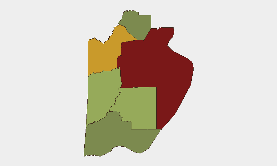
Belize District (composite risk 95) dominates the threat landscape, driven by concentrated urban violence in and around Belize City, compounded by gang activity and organized-crime competition. The two homicides on 13 June—both in or near Belize City—exemplify the district's chronic exposure to targeted firearms killings. Orange Walk District (risk 72) and Cayo District (risk 58) carry secondary but material risk from similar organized-crime dynamics; southern districts (Toledo, Stann Creek) currently face environmental/flooding hazard rather than security-based threats, though road degradation may isolate communities temporarily.
How GeoBit Would Assist
Intel Sweep and OSINT fusion across X/Twitter, Telegram, local news, and YouTube enable real-time tracking of homicide patterns, cartel-rumor verification, and organized-crime actor activity across Belize City and northern borders. AOI Monitoring & Early Warning persistent watch of high-risk districts (Belize, Orange Walk) combined with sentiment & temporal analysis would alert security teams to escalation in violence frequency or rhetoric before incidents occur. Routing & Network Analysis integrated with environmental monitoring provides alternative-route planning around flooded southern roads and real-time travel-risk assessment for personnel and asset movements.
7-Day Outlook
Homicide risk in Belize City and urban Orange Walk will likely persist at current levels absent significant enforcement action; no indicators suggest imminent cessation of gang or organized-crime violence. Rainfall will continue through mid-week, potentially worsening flooding in Toledo and Stann Creek; road closures and access delays should be anticipated for southern-district operations. By late next week, weather will clear, but assessments of road integrity and debris-clearance progress will be necessary before normalizing logistics in affected zones.
Highest-Risk Areas — Ranked
| # | State / Region | Risk |
|---|---|---|
| 1 | Belize District | 95 |
| 2 | Orange Walk District | 72 |
| 3 | Cayo District | 58 |
| 4 | Stann Creek District | 48 |
| 5 | Toledo District | 35 |
| 6 | Corozal District | 22 |
Sources
Previous Daily Briefs
A new Belize brief is written every day — each with its own risk map and downloadable CSV. Here's the last week; use the calendar to go further back.
📅 Browse every day by calendar →
Highlighted days have a brief. Tap a day for that day's map & analysis, or “csv” for that day's dataset ($5).