Résumé de la situation
Le Belize présente un classement de menace composite de 21 au niveau mondial, sans incident de sécurité aigu confirmé, attaque terroriste ou agitation civile majeure signalée au cours des 24 à 48 dernières heures. Le risque opérationnel actuel est concentré dans le district de Belize (score 95) et le district d'Orange Walk (score 72), alimentés par une activité de gang persistante, des incidents d'armes légères et des dynamiques de criminalité organisée plutôt que par une déstabilisation aiguë. Une attention à court terme est justifiée pour les inondations localisées dans les districts du sud et la désinformation en ligne élevée concernant l'activité des cartels, bien que ni l'un ni l'autre ne pose de perturbation immédiate des déplacements ou des actifs au niveau national.
Développements clés
- Incident de combat aux armes légères (district de Belize, 2026-06-15) : Le signal d'événement GeoBit a signalé un engagement armé dans le district à plus haut risque du pays ; aucun nombre de victimes ou détail de localisation corroboré par les sources ouvertes au cours des 24 dernières heures.
- Agression physique impliquant la police (Belize, 2026-06-15) : Confrontation signalée entre un civil et du personnel chargé de l'application de la loi ; détails et localisation non confirmés par les principaux médias au cours de la fenêtre de signalement.
- Action d'enquête concernant un prétendu acteur terroriste (Belize, 2026-06-15) : Le signal indique une activité d'enquête officielle ; aucune attaque corroborée, annonce d'arrestation ou déclaration d'incident public disponible à partir de sources fiables à partir de 2026-06-15.
- Réaction aux fortes pluies et inondations (Belize méridional—districts de Toledo/Stann Creek, 48 dernières heures) : Équipes d'intervention d'urgence déployées pour les inondations localisées suite aux précipitations récentes ; le risque principal est la dégradation temporaire des routes et les perturbations mineures des infrastructures dans les zones rurales, non des dommages généralisés ou du désordre civil.
- Système tropical faible qui s'approche (Golfe du Mexique/région du Belize, perspective pour les jours à venir) : Système de basse pression suivi vers le Belize–Yucatán ; la modélisation météorologique indique une faible probabilité de développement tropical (chance de formation de 10 % en 48 heures) et principalement une augmentation des pluies/orages, non une menace de niveau cyclonique.
- Avis de désinformation sur les médias sociaux (récit de la frontière Belize–Mexique, diffusé au cours des 48 dernières heures) : Les autorités du Belize ont publiquement mis en garde contre les affirmations exagérées ou fausses de violences liées aux cartels sur les médias sociaux ; aucun incident aigu de cartel transfrontalier corroboré ou violence débordante à l'intérieur du Belize signalé par les sources grand public.
- Signaux de désapprobation publique/sentiment civique (2026-06-13, 2026-06-15) : Les flux d'événements GeoBit ont signalé un sentiment civique négatif et un indicateur de friction bilatérale (Belize c. Nicaragua) ; les déclencheurs spécifiques et l'ampleur de l'expression ne sont pas clairs à partir de l'OSINT ouvert au cours de la fenêtre de signalement.
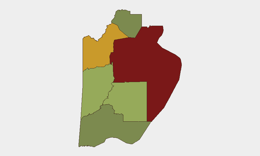
Zones à plus haut risque
Le district de Belize domine le paysage des risques (score 95), alimenté par la consolidation des gangs, la violence inter-cartels et les incidents d'armes légères concentrés dans la ville de Belize et les zones urbaines environnantes. Le district d'Orange Walk (score 72) reflète des dynamiques similaires de criminalité organisée et de trafic de stupéfiants, aggravées par sa position sur les corridors de trafic face au Mexique. Le district de Cayo (score 58) et Stann Creek (score 48) présentent un risque modéré, principalement en raison de l'activité débordante des gangs et de la présence de criminalité organisée en milieu rural. Les districts de Corozal et Toledo présentent des profils de menace plus faibles, bien que les inondations à Toledo exigent actuellement une attention logistique à court terme.
Comment GeoBit serait utile
Les équipes de sécurité multinationales et régionales déploieraient la surveillance de l'AOI et l'alerte précoce sur le district de Belize et le district d'Orange Walk pour suivre l'activité des gangs et des cartels avec une précision sous-régionale et un réglage du seuil d'alerte. La fusion et corroboration OSINT (X/Twitter, Telegram, médias locaux et renseignement radioélectrique) clarifieraient les signaux d'événements—tels que les incidents de combat et de police du 2026-06-15—par rapport à la désinformation et quantifieraient la gravité de la menace. L'analyse du réseau et des acteurs cartographierait les structures des groupes de criminalité organisée, les changements de leadership et les changements territoriaux pour anticiper les flambées localisées et informer l'acheminement du devoir de diligence et le positionnement des actifs.
Perspective à 7 jours
La posture de sécurité du Belize devrait rester stable au niveau national, avec des incidents liés aux gangs probables à Belize City et Orange Walk, mais sans indication de déstabilisation coordonnée. Les inondations dans les districts du sud devraient diminuer à mesure que le système météorologique qui s'approche passe ; le risque de cyclone tropical reste faible. La gestion de la désinformation et la surveillance des courants transfrontaliers Belize–Mexique resteront pertinentes pour prévenir l'escalade en cascade des alarmes ou la fausse escalade.
Zones les Plus à Risque — Classées
| # | État / Région | Risque |
|---|---|---|
| 1 | Belize District | 95 |
| 2 | Orange Walk District | 72 |
| 3 | Cayo District | 58 |
| 4 | Stann Creek District | 48 |
| 5 | Toledo District | 35 |
| 6 | Corozal District | 22 |
Sources
Bulletins Quotidiens Précédents
Un nouveau bulletin Belize est publié chaque jour — chacun avec sa carte de risque et son CSV téléchargeable. Voici la dernière semaine ; utilisez le calendrier pour remonter plus loin.
📅 Browse every day by calendar →
Highlighted days have a brief. Tap a day for that day's map & analysis, or “csv” for that day's dataset ($5).