Situation Summary
Belize is experiencing endemic gang and organized crime activity, with Belize District and Orange Walk District as persistent hotspots, but no confirmed acute security incidents—terrorist attacks, civil unrest, or major destabilizing events—have been reported in the last 24–48 hours. A short-term spike in shooting incidents in Belize City appears to have occurred over the past week, though specific timing to within the last 24 hours cannot be reliably established from open sources. Minor localized flooding in southern districts (Toledo and Stann Creek) has prompted emergency response activity but has caused no widespread disorder. The overall threat trajectory remains defined by chronic gang violence rather than new, acute triggers.
Key Developments
- Belize City, Belize District – *past 7 days, specific timing unclear* – A surge in shooting incidents has been reported, with at least 11 persons shot and 6 killed in recent days; however, open-source reporting does not precisely time-stamp individual incidents to the last 24 hours, and some killings appear to date to mid-week (e.g., 15 June).
- Toledo and Stann Creek Districts, Southern Belize – *18–20 June* – Localized flooding after heavy rainfall has triggered emergency response team deployment; temporary road degradation and minor infrastructure disruption reported in rural areas, with no widespread damage or civil disorder.
- Belize District and Orange Walk District – *18–20 June* – Persistent gang and small-arms activity remains at elevated levels; no new acute incidents confirmed in the last 24–48 hours, but the districts continue to drive national risk scores.
- Nationwide – *18–20 June* – No confirmed terrorist attacks, major civil unrest, or destabilizing events reported; current security picture remains shaped by ongoing organized crime rather than new political, communal, or external shocks.
Highest-Risk Areas
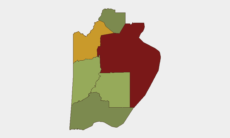
Belize District (composite risk 95), encompassing Belize City, is the dominant driver of national insecurity due to gang territorial disputes and street-level shootings. Orange Walk District (risk 72) follows as a secondary hotspot for similar gang-related violence and organized crime. Cayo District (risk 58) and Stann Creek District (risk 48) carry moderate risk; Toledo District (risk 35) and Corozal District (risk 22) are comparatively lower-risk. The concentration of gang activity in the northern and central urban/semi-urban corridors reflects established smuggling routes, territorial control, and economic desperation in densely populated areas.
How GeoBit Would Assist
Security and risk teams can deploy AOI Monitoring & Early Warning on Belize City, Orange Walk, and surrounding districts to detect emerging flare-ups in gang activity and violence clusters before they escalate. Network & Actor Analysis and entity extraction applied to local crime reports, police statements, and gang-affiliated social media can map leadership changes, territorial shifts, and recruitment patterns. Multi-language OSINT and sentiment analysis on Spanish-language and Creole-language sources, combined with temporal analysis, improve precision in assigning incidents to specific windows and reducing the false-dating of older events as current, a challenge evident in this week's reporting.
7-Day Outlook
Gang violence in Belize City and Orange Walk is likely to remain at current endemic levels absent a major police intervention, leadership assassination, or territorial consolidation. Localized flooding in the south is expected to subside as weather normalizes, restoring road access. No major political, communal, or external shock is anticipated in the near term.
Highest-Risk Areas — Ranked
| # | State / Region | Risk |
|---|---|---|
| 1 | Belize District | 95 |
| 2 | Orange Walk District | 72 |
| 3 | Cayo District | 58 |
| 4 | Stann Creek District | 48 |
| 5 | Toledo District | 35 |
| 6 | Corozal District | 22 |
Sources
Previous Daily Briefs
A new Belize brief is written every day — each with its own risk map and downloadable CSV. Here's the last week; use the calendar to go further back.
📅 Browse every day by calendar →
Highlighted days have a brief. Tap a day for that day's map & analysis, or “csv” for that day's dataset ($5).