Situation Summary
Bolivia is experiencing its second consecutive week of nationwide anti-government unrest, marked by violent clashes between security forces and protest groups, attempted storming of government buildings, and widespread roadblocks disrupting critical transport corridors. Political demands have escalated from sector-specific grievances (fuel access, agricultural policy) to explicit calls for presidential resignation, signaling a shift toward systemic governance challenge. Simultaneously, organized crime operations linked to Brazilian mafias are driving a separate security crisis in Santa Cruz and eastern regions, with dozens of homicides and major police-military counter-narcotics operations underway. The convergence of political instability and organized crime activity creates compounded risk for personnel and assets, particularly in La Paz and the eastern corridor.
Key Developments
- La Paz, 2026-06-02/04 – Violent clashes at government palace: Artisanal and cooperative miners detonated small dynamite charges and attempted to breach the government palace area; police responded with tear gas and crowd-control measures. Protesters also attempted to storm the vice president's office and held contested ground in central squares.
- La Paz – Expanded protest demands: Initial calls for better access to explosives and fuel have evolved into nationwide demands for President Rodrigo Paz's resignation, indicating political risk has moved beyond labor/sectoral negotiation into existential governance challenge.
- Multiple regions – Nationwide roadblocks and strikes: Miners, rural organizations, and social movements have implemented intermittent and ongoing roadblocks on key highways into La Paz, disrupting inter-city bus and cargo movements and restricting overland travel.
- La Paz – Cabinet instability: Several government ministers have resigned or face intense pressure, signaling internal administrative strain and heightened short-term policy uncertainty.
- Santa Cruz – Large-scale organized crime operation: Combined police and military forces have launched a "massive" and long-term security operation targeting contract killings, Brazilian mafia-linked criminal networks, and cross-border illicit economies.
- Santa Cruz and eastern corridor – Mafia-linked homicide surge: Dozens of killings attributed to organized criminal groups with Brazilian mafia links have prompted increased patrols, checkpoints, and intelligence operations across urban and transport corridors in the region.
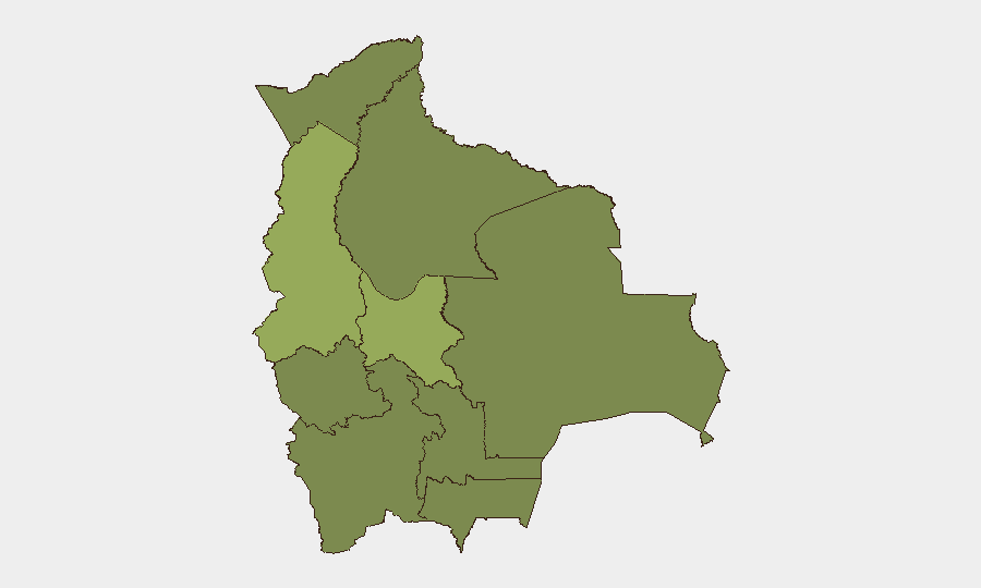
Highest-Risk Areas
La Paz and Cochabamba drive national risk, with composite scores of 54.6 and 42.8 respectively. La Paz's elevated threat reflects the ongoing political unrest, violent clashes at government institutions, and disruption to movement via roadblocks and protest activity. Cochabamba's secondary risk reflects its role as a hub for rural and mining-sector organizing and its geographic position within protest supply chains. The remaining departments register materially lower but uniform risk (24.6), reflecting baseline organized crime and criminal activity but not the intensity of political upheaval or violent street confrontation concentrated in the capital and central highlands.
How GeoBit Would Assist
Security teams monitoring Bolivia should employ AOI Monitoring & Early Warning on La Paz government quarters, key highways, and Santa Cruz urban corridors to detect protest movement, roadblock deployment, and security-force activity in real-time. Intelligence & OSINT capabilities (X/Twitter, Telegram OSINT, event feeds, and multi-language search) enable continuous tracking of protest messaging, organizational calls, and criminal-network activity to anticipate flashpoints and assess escalation likelihood. Routing & Network Analysis supports alternative journey planning and checkpoint-risk assessment for personnel movement, while Risk & Threat Assessment integrates event signals with sub-national scoring to enable duty-of-care decision-making on presence and operations.
7-Day Outlook
Unrest is likely to persist into the second week of June as political demands remain unmet and government response continues. Roadblocks may intensify or shift location in response to police clearing efforts, affecting transport reliability and personnel movement. Organized crime operations in Santa Cruz are expected to continue independently of political unrest, creating bifurcated risk requiring separate mitigation postures in the capital versus eastern regions.
Highest-Risk Areas — Ranked
| # | State / Region | Risk |
|---|---|---|
| 1 | La Paz | 54.6 |
| 2 | Cochabamba | 42.8 |
| 3 | Potosí | 28.3 |
| 4 | Tarija | 24.6 |
| 5 | Pando | 24.6 |
| 6 | Beni | 24.6 |
| 7 | Oruro | 24.6 |
| 8 | Chuquisaca | 24.6 |
| 9 | Santa Cruz | 24.6 |
Previous Daily Briefs
A new Bolivia brief is written every day — each with its own risk map and downloadable CSV. Here's the last week; use the calendar to go further back.
📅 Browse every day by calendar →
Highlighted days have a brief. Tap a day for that day's map & analysis, or “csv” for that day's dataset ($5).