Situation Summary
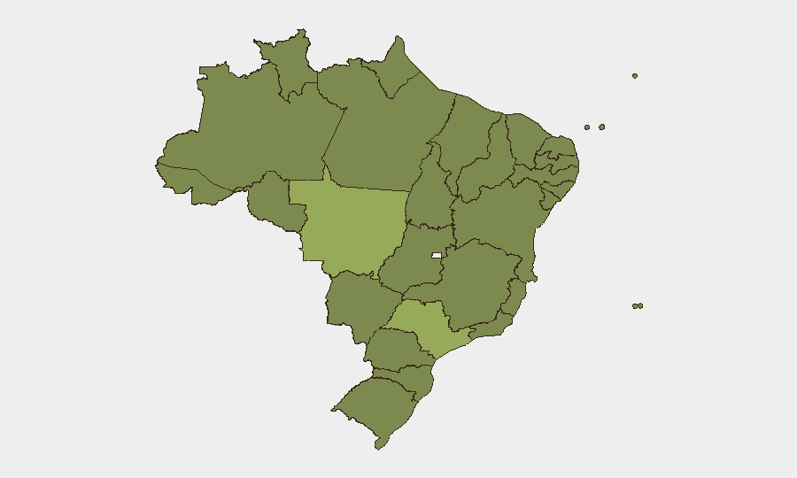
Brazil remains a composite threat level #33 globally, with a nationwide security environment characterized by persistent violent crime, organized-crime activity, and kidnapping risk in major urban centers and border regions. Sub-national risk is highly concentrated, with Mato Grosso (59.3) and São Paulo (46.7) substantially exceeding the national average, while 10 of 12 highest-risk states cluster between 29.8 and 33.7. Recent U.S. Embassy advisory updates and multi-actor political/commercial disputes signal continued operational friction across security, governance, and commerce domains.
Key Developments
- Nationwide travel advisory (2026-06-03): U.S. Embassy reissued countrywide caution notice emphasizing kidnapping, violent crime, carjackings, and armed robbery targeting foreign nationals; municipal bus use prohibited for U.S. personnel due to robbery/assault risk.
- Border zones (160 km from international boundaries): All land-border regions remain under "do not travel" classification due to organized-crime, smuggling, and security-force activity; exceptions limited to Foz do Iguaçu and Pantanal national parks.
- Rio de Janeiro & São Paulo urban crime: Armed robbery, carjacking, and sedative-facilitated assault via bars and dating apps noted as persistent threats; incidents reported across day and night hours in both cities.
- Brasília satellite cities (Ceilândia, Santa Maria, São Sebastião, Paranoá): After-hours (18:00–06:00) travel restrictions imposed for U.S. government staff, indicating localized violent and property crime concentration.
- Favelas/informal settlements: Gang-conflict and police-clash activity continue; areas marketed as "pacified" remain unpredictably volatile; official travel prohibited.
- Political and commercial friction (2026-06-02–06-03): Multiple public statements, rejections, and investigative signals involving government, entrepreneurial, and company actors suggest ongoing policy or commercial disputes; one military-force event recorded (terrorist vs. gangdom).
- Kidnap-for-ransom emphasis: Updated advisory reflects documented incidents of abduction targeting U.S. citizens, positioning kidnapping as a distinct and elevated threat category beyond general violent crime.
Highest-Risk Areas
Mato Grosso and São Paulo dominate the risk landscape, with Mato Grosso's score (59.3) nearly 44% above the national mean. São Paulo's rank (46.7) reflects concentrated urban crime and organized-crime presence in Brazil's largest economic center. The second tier—Rio de Janeiro (34), Amazonas (33.7), and Pernambuco (32.8)—combines urban violence with border/frontier instability and criminal-gang territorial conflicts. Risk clustering in the northern (Amazonas, Tocantins) and central-west (Mato Grosso, Mato Grosso do Sul, Goiás) regions correlates with remote geography, land-border adjacency, and weak state security presence, while southern and northeastern states (Bahia, Ceará, Rio Grande do Sul) show moderately elevated but more manageable threat profiles.
How GeoBit Would Assist
Corporate teams operating in Brazil should employ AOI Monitoring & Early Warning on Mato Grosso, São Paulo, and border regions to track real-time event clusters and rapid threat escalation. Network & Actor Analysis combined with OSINT fusion (X/Twitter, Telegram, local news feeds) enables identification of organized-crime and gang-activity shifts affecting supply chains or personnel movement. Routing & Network Analysis provides alternative transport and facility-access planning to avoid high-risk corridors, checkpoints, and favela adjacency while maintaining operational continuity.
7-Day Outlook
Violent-crime and kidnapping risk remain elevated and likely stable over the near term; no immediate nationwide escalation signals are present, but localized gang conflicts and police operations in favelas may create sudden operational disruptions. Political and commercial disputes noted in recent event feeds warrant continued monitoring for policy changes or supply-chain impacts.
Highest-Risk Areas — Ranked
| # | State / Region | Risk |
|---|---|---|
| 1 | Mato Grosso | 59.3 |
| 2 | São Paulo | 46.7 |
| 3 | Rio de Janeiro | 34 |
| 4 | Amazonas | 33.7 |
| 5 | Pernambuco | 32.8 |
| 6 | Bahia | 31.5 |
| 7 | Mato Grosso do Sul | 30.8 |
| 8 | Goiás | 30.7 |
| 9 | Ceará | 30.6 |
| 10 | Tocantins | 30.6 |
| 11 | Minas Gerais | 30.1 |
| 12 | Rio Grande do Sul | 29.8 |
Sources
Previous Daily Briefs
A new Brazil brief is written every day — each with its own risk map and downloadable CSV. Here's the last week; use the calendar to go further back.
📅 Browse every day by calendar →
Highlighted days have a brief. Tap a day for that day's map & analysis, or “csv” for that day's dataset ($5).