Situation Summary
Brunei remains a low-threat environment with no acute security incidents, civil unrest, infrastructure disruption, or travel-risk events reported in the last 24–48 hours. The composite national threat score is 2 (ranked #null globally), reflecting the nation's political stability, effective law enforcement, and absence of active conflict or organized terrorism. Current activity is dominated by routine governance, tourism promotion, and educational events with no indicators of deterioration in the security baseline.
Key Developments
No credible security, conflict, civil unrest, serious crime, political instability, infrastructure disruption, or travel-risk incidents meeting threat criteria were identified in Brunei during the 24–48 hour reporting window (2026-06-18 to 2026-06-20).
Recent routine activity (not security-significant):
- 2026-06-20 · Visit Brunei Year 2027 pre-launch event held at Jerudong Park Garden; cultural/tourism promotion activity.
- Mid-June 2026 · Ministry of Foreign Affairs public statements issued on Middle East developments and procurement notices; no domestic security alerts.
- Educational symposium activity at Universiti Brunei Darussalam continues; no disruptions reported.
No new travel advisories, terrorism alerts, protest activity, major crime incidents, or infrastructure outages have been issued or detected in open sources for this period.
Highest-Risk Areas
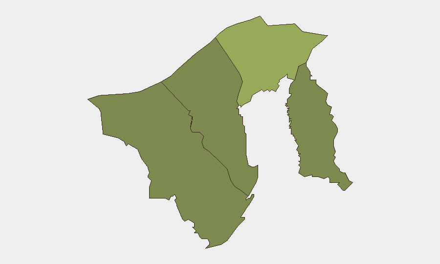
Brunei-Muara District (composite risk score 45) remains the highest-risk jurisdiction, driven by its status as the administrative and commercial hub containing the capital, Bandar Seri Begawan, and concentration of government, financial, and diplomatic infrastructure. Tutong District (risk 20) and Belait District (risk 15) carry secondary risk, likely reflecting smaller population density and lower critical-infrastructure density. Temburong District (risk 10) remains the lowest-risk area. No acute incidents in any district alter this baseline ranking; risk scores reflect structural and demographic factors rather than active events.
How GeoBit Would Assist
Corporate security teams operating in Brunei should employ AOI Monitoring & Early Warning (persistent area-of-interest watch on Bandar Seri Begawan and key infrastructure nodes) to detect any sudden shift in incident frequency, protest activity, or crowd assembly. Multi-language OSINT and social-media monitoring (X/Twitter, Telegram, local forums) coupled with sentiment & temporal analysis will provide early warning of emerging grievances or coordination signals before formal incidents occur. Routing & Network Analysis can be deployed to pre-identify safe transit corridors and alternative routes for personnel moving between high-risk districts and expatriate residential/commercial zones should any localized disruption emerge.
7-Day Outlook
Brunei's security environment is forecast to remain stable over the next seven days absent unforeseen exogenous shocks (regional spillover, major diplomatic crisis, or natural disaster). Routine governance, tourism activity, and education continue without reported friction. GeoBit will maintain continuous monitoring for any deviation from this baseline and issue alert-style guidance immediately if credible threats to personnel, assets, or operations emerge.
Highest-Risk Areas — Ranked
| # | State / Region | Risk |
|---|---|---|
| 1 | Brunei-Muara District | 45 |
| 2 | Tutong District | 20 |
| 3 | Belait District | 15 |
| 4 | Temburong District | 10 |
Previous Daily Briefs
A new Brunei brief is written every day — each with its own risk map and downloadable CSV. Here's the last week; use the calendar to go further back.
📅 Browse every day by calendar →
Highlighted days have a brief. Tap a day for that day's map & analysis, or “csv” for that day's dataset ($5).