Situation Summary
Burkina Faso remains in an acute security crisis, with jihadist and state-linked violence sustaining extreme lethality and territorial contestation across most of the national territory. An estimated 5,274 conflict-related deaths in 2025, coupled with the siege of approximately 130 towns and effective militant control or contestation of roughly 70% of the country, reflects a multi-year deterioration in state control and civilian safety. Insecurity has now spread westward into the Boucle du Mouhoun region, previously less affected, signaling a geographic expansion of risk and a constraint on overland movement nationwide. Ouagadougou remains alert to spillover threats following regional violence in Mali, though the capital has not experienced a major attack in recent weeks.
Key Developments
- Northern provinces and Sahel Region: Jihadist groups continue to besiege towns including Djibo, where a prior barracks attack killed at least 210 personnel; ongoing ambush and IED activity maintains extreme risk on all approaches to encircled settlements.
- Boucle du Mouhoun region (west): Conflict and displacement intensity accelerated sharply in 2025, accounting for approximately half of all new national internal displacement; westward expansion of insecurity has opened previously lower-risk overland routes to significant threat.
- Nationwide town encirclement: Approximately 130 towns and cities remain under siege by armed Islamist groups, severing key road corridors linking Ouagadougou to Togo, Benin, Niger, Mali, and Côte d'Ivoire; major inter-urban and cross-border movement is severely constrained.
- Territory control fragmentation: Jihadist groups now contest or control ~70% of Burkina Faso; state armed forces operate freely in only ~30%, creating widespread security vacuums and high likelihood of encountering non-state armed actors on secondary routes.
- Humanitarian infrastructure collapse: Over 5,000 schools remain closed (affecting 800,000+ children) and more than 4 million people lack access to functional health services due to insecurity; rural zones are effectively no-go areas for routine civilian movement and aid operations.
- Displacement surge: Approximately 400,000 new internally displaced persons were registered in 2025, compounding a pre-existing displaced population exceeding 2 million; strain on urban centers and degraded road security in displacement hubs elevates travel and logistics risk.
- Ouagadougou heightened alert: Following major attacks in neighboring Mali, Burkinabe authorities have increased security patrols around airports, military installations, and government buildings, and are soliciting public reporting of suspicious activity; potential for spillover or retaliatory incidents remains.
- Civil-society constraints: The junta has dissolved over 100 NGOs following reports of state and allied-force abuses; deterioration in rule of law and human-rights oversight reduces independent monitoring and increases political-instability risk.
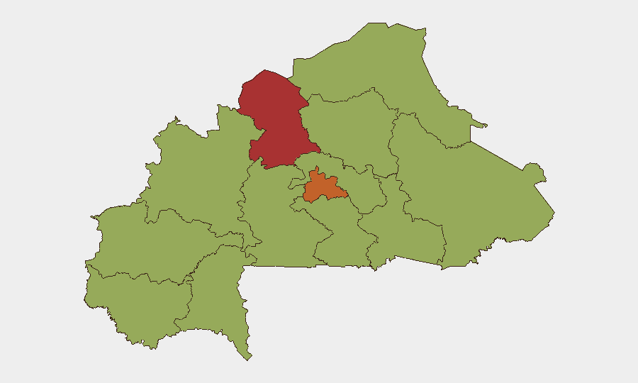
Highest-Risk Areas
The North and Centre regions drive national risk (scores 78.3 and 73.3, respectively), reflecting sustained jihadist operational intensity, town sieges, and state-force engagement in these zones. The Boucle du Mouhoun region, despite a composite score of 48.3 (shared with nine other regions), represents a critical emerging hotspot due to the 2025 acceleration of conflict and displacement; this westward spread materially increases risk on overland routes previously considered lower-threat and signals a widening operational footprint by non-state armed actors. The remaining ten regions at 48.3 reflect either ongoing baseline insecurity or areas where data density is lower; however, the blockade of inter-regional routes means that even lower-scored regions face elevated travel risk due to encirclement effects and checkpoint activity.
How GeoBit Would Assist
Security teams would employ AOI Monitoring & Early Warning for persistent watch on encircled towns and displacement hubs; Routing & Network Analysis to identify and vet alternative overland and air-transport corridors; and Conflict & Military battle mapping coupled with Network & Actor Analysis to track jihadist group positioning and state-force movements in real time. Intel Sweep and OSINT fusion capabilities would aggregate incident reports, checkpoint activity, and transport-corridor status from multiple sources to inform duty-of-care decisions on staff movement and asset location.
7-Day Outlook
No major de-escalation is anticipated within the next week. Jihadist-group activity and town sieges are expected to persist at current intensity, with continued risk of ambush, IED deployment, and checkpoint harassment on inter-urban routes. Ouagadougou's heightened security posture suggests elevated vigilance around government and military installations; corporate teams should monitor local security advisories and consider contingency planning for temporary movement restrictions in the capital.
Highest-Risk Areas — Ranked
| # | State / Region | Risk |
|---|---|---|
| 1 | North | 78.3 |
| 2 | Centre | 73.3 |
| 3 | Upper-Basins | 48.3 |
| 4 | Boucle du Mouhoun | 48.3 |
| 5 | Central-West | 48.3 |
| 6 | Central-South | 48.3 |
| 7 | Central-East | 48.3 |
| 8 | Waterfalls | 48.3 |
| 9 | Southwest | 48.3 |
| 10 | Sahel | 48.3 |
| 11 | Central-North | 48.3 |
| 12 | East | 48.3 |
Sources
Previous Daily Briefs
A new Burkina Faso brief is written every day — each with its own risk map and downloadable CSV. Here's the last week; use the calendar to go further back.
📅 Browse every day by calendar →
Highlighted days have a brief. Tap a day for that day's map & analysis, or “csv” for that day's dataset ($5).