Situation Summary
Cameroon remains a complex, multi-theatre security environment ranked #26 globally with a composite threat score of 69.3, driven primarily by active insurgency across the anglophone regions and far-north terrorism. The security picture is characterized by persistent separatist conflict in the Northwest and Southwest, Boko Haram and ISWAP activity in the Far North, urban crime in major cities, and restricted political space with episodic unrest. While no major incident has been independently verified in the last 24 hours via open English and French sources, the underlying operational tempo—including recent village attacks, IED deployments, and abductions—indicates sustained and mobile threat patterns that continue to deteriorate livelihoods and movement freedoms across affected zones.
Key Developments
- Northwest Region (Wowo, Gidado, Mbat, near Ndop/Kumbo belt): Recent separatist-government clashes have resulted in village attacks and burnings with at least 23 civilian deaths and hundreds displaced; pattern reflects sustained arson, raids, and forced displacement in rural anglophone areas.
- Northwest & Southwest Regions (Bui, Momo, Mezam, Fako districts): Non-state armed groups are increasingly deploying IEDs against military and convoys along highways and near urban centers, raising direct risk to movement corridors and transit zones.
- Far North Region (Mayo-Sava, Mayo-Tsanaga, Logone-et-Chari departments, Lake Chad basin): Boko Haram and ISWAP continue frequent attacks including killings, abductions, and village raids; this zone remains subject to international "do not travel" advisories due to terrorism and kidnapping threats.
- Major urban centers (Yaoundé, Douala, Ngaoundéré, Bafoussam): Armed robbery, mugging, and carjacking—particularly after dark and in less-secured districts—remain persistent threats to foreign nationals and affluent targets; violent crime advisories remain active.
- Border zones within ~20 km of CAR, Chad, and Nigeria (East, North, Far North, Adamawa): Kidnapping for ransom, cross-border banditry, and militant incursions create elevated risk; multiple states advise against all travel to these areas.
- Selected rural and peri-urban zones (Northwest, Southwest, Far North, Adamawa, East): Gang-based and armed-group kidnapping for ransom affecting aid workers, clergy, local elites, and travelers on secondary roads remains endemic.
- National political environment (Yaoundé and Douala focal points): Restricted political space with periodic unrest around electoral or governance issues can occur with little warning, disrupting movement and services in central urban areas.
- Media and civil society sphere (Yaoundé, Douala): Journalists and human-rights actors continue to face threats and violence; under-reporting of security incidents complicates real-time situational awareness.
Highest-Risk Areas
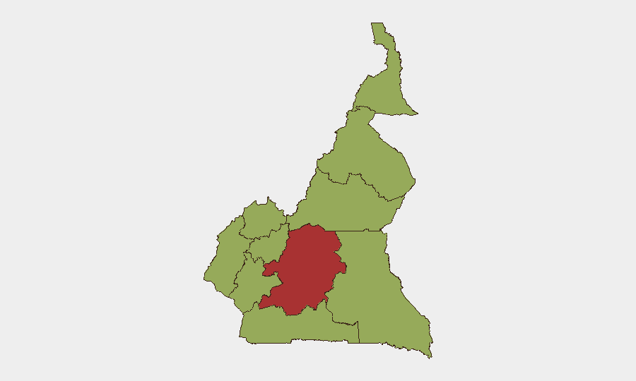
Centre Region dominates the sub-national ranking (78.5) as the seat of government and primary locus of political risk and urban crime. Adamawa (55.4) faces cross-border banditry and terrorism from Lake Chad basin groups. Northwest and Southwest regions, tied at 48.5, are the epicenters of the separatist conflict with the highest density of IED and armed-group activity. The remaining eight regions—North, East, Far-North, South, Littoral, and West—all score 48.5, indicating that threat distribution has become more diffused and pervasive across the country than concentrated in a few zones.
How GeoBit Would Assist
Security teams operating in Cameroon should prioritize AOI Monitoring & Early Warning on the Northwest/Southwest anglophone belt and Far North Lake Chad basin to detect IED placement, militant movement, and abduction attempts in near-real-time. Multi-language OSINT (French and local-language social-media, Telegram, and radio SIGINT) will capture incident reporting ahead of international wire delays and fill gaps in English-language open sources. Routing & Network Analysis enables identification of alternative movement corridors that avoid IED hotspots and kidnapping zones identified through conflict mapping and entity/network analysis of armed groups and their operational footprints.
7-Day Outlook
The operational tempo in anglophone and far-north regions is expected to remain elevated, with separatist and Islamist groups maintaining raid and IED activity at current levels or higher as dry-season conditions ease movement. No major political trigger is immediately visible, but the restricted political environment and seasonal displacement patterns suggest sustained background risk across urban and rural movement corridors. Personnel and asset movement should assume persistent threat conditions on secondary roads and after-hours urban transit.
Highest-Risk Areas — Ranked
| # | State / Region | Risk |
|---|---|---|
| 1 | Centre | 78.5 |
| 2 | Adamawa | 55.4 |
| 3 | Northwest | 48.5 |
| 4 | Southwest | 48.5 |
| 5 | West | 48.5 |
| 6 | Littoral | 48.5 |
| 7 | South | 48.5 |
| 8 | Far-North | 48.5 |
| 9 | North | 48.5 |
| 10 | East | 48.5 |
Previous Daily Briefs
A new Cameroon brief is written every day — each with its own risk map and downloadable CSV. Here's the last week; use the calendar to go further back.
📅 Browse every day by calendar →
Highlighted days have a brief. Tap a day for that day's map & analysis, or “csv” for that day's dataset ($5).