Situation Summary
Chad remains a persistently high-threat environment (global rank #22, composite score 71.2) marked by active terrorism, civil unrest risk, and law-enforcement volatility. The Lake Chad region is currently under a 20-day state of emergency following Boko Haram/ISWAP attacks in May that killed senior military personnel and prompted expanded security operations across border zones. Political and economic grievances continue to fuel demonstration risk nationwide, with authorities maintaining a pattern of internet disruptions and arrest-based crowd control. The baseline security posture reflects limited state capacity outside N'Djamena, persistent landmine/UXO hazards, and restricted freedom of movement and communications.
Key Developments
- Lake Chad Province (western Chad), 2026-06-03 – State of emergency now in its third week following coordinated attacks on military installations; Barka Tolorom/Barka Toulloum base raid resulted in 24+ soldier casualties; security forces have expanded stop-and-search powers and movement restrictions remain in effect.
- Lake Chad Islands & Nigeria/Niger/Cameroon Border Zone, 2026-06-03 – Intensified counter-terrorism sweeps ongoing against Boko Haram and ISWAP cells using remote islands as operational bases; civilian displacement and ongoing military pressure continue to shape the operational environment.
- N'Djamena & Major Urban Centres, 2026-06-02/03 – Multiple public statements and police arrest/detain events suggest elevated political friction; demonstration risk remains elevated with authorities positioned to use internet cuts and checkpoints as control measures.
- Nationwide (Chad vs. Iran), 2026-06-03 – Public statements and reported unconventional violence incident signal diplomatic and possible covert tensions; implications for foreign personnel and asset exposure remain unclear pending further clarification.
- N'Djamena Checkpoints & Roads, ongoing – Ad-hoc roadblocks, vehicle searches, and ID checks persist, particularly at night; harassment and bribery solicitation remain routine friction points for residents and foreign travelers.
- Border Regions & Secondary Road Networks, ongoing – Landmines and unexploded ordnance from prior conflicts pose travel hazards; rural and cross-border movement remains elevated-risk without specialized route planning.
Highest-Risk Areas
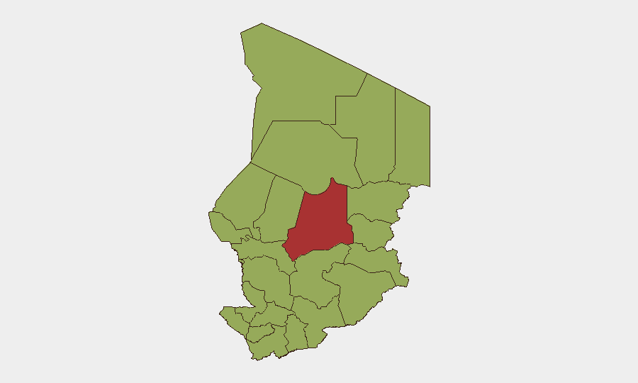
Batha emerges as the dominant risk driver (79.8), significantly outpacing all other regions and reflecting the Lake Chad emergency zone intensity. The remaining 11 tracked regions (Ennedi-Ouest, Wadi Fira, Ouaddaï, Sila, Salamat, East Ennedi, Kanem, Lac, N'Djamena, Hadjer-Lamis, Chari-Baguirmi) cluster at 49.8, indicating secondary but sustained threat signatures across terrorism, displacement, and law-enforcement volatility. The gap between Batha and other regions reflects the concentrated impact of recent Boko Haram/ISWAP activity and the emergency response. Teams with assets or personnel in Lac, Kanem, and the cross-border zones should prioritize updated threat intelligence, as these regions adjoin active terrorist sanctuaries.
How GeoBit Would Assist
Security teams should deploy AOI Monitoring & Early Warning on Batha and Lake Chad border zones to track military posture changes, displacement flows, and attack signaling in real time. Conflict & Military battle mapping and Network & Actor Analysis of Boko Haram/ISWAP cell activity would clarify operational patterns and sanctuary usage. Routing & Network Analysis for alternative journey planning, combined with OSINT fusion (X/Telegram feeds, radio SIGINT) on checkpoint locations and internet disruption announcements, enables informed travel and evacuation decisions. Early Warning & Prediction feeds on political statements and police action clustering help forecast demonstration risk and control measures.
7-Day Outlook
The 20-day Lake Chad emergency is expected to continue with no imminent stand-down signals; counter-terrorism operations will likely sustain elevated intensity. Political friction signals (public statements, arrests, Iran tensions) suggest near-term risk of civil unrest or demonstration activity in N'Djamena, with corresponding internet disruption and checkpoint escalation probable. External event triggers (diplomatic incidents, major attack, or personnel casualty) could accelerate deterioration across multiple risk vectors.
Highest-Risk Areas — Ranked
| # | State / Region | Risk |
|---|---|---|
| 1 | Batha | 79.8 |
| 2 | Ennedi-Ouest | 49.8 |
| 3 | Wadi Fira | 49.8 |
| 4 | Ouaddaï | 49.8 |
| 5 | Sila | 49.8 |
| 6 | Salamat | 49.8 |
| 7 | East Ennedi | 49.8 |
| 8 | Kanem | 49.8 |
| 9 | Lac | 49.8 |
| 10 | N'Djamena | 49.8 |
| 11 | Hadjer-Lamis | 49.8 |
| 12 | Chari-Baguirmi | 49.8 |
Previous Daily Briefs
A new Chad brief is written every day — each with its own risk map and downloadable CSV. Here's the last week; use the calendar to go further back.
📅 Browse every day by calendar →
Highlighted days have a brief. Tap a day for that day's map & analysis, or “csv” for that day's dataset ($5).