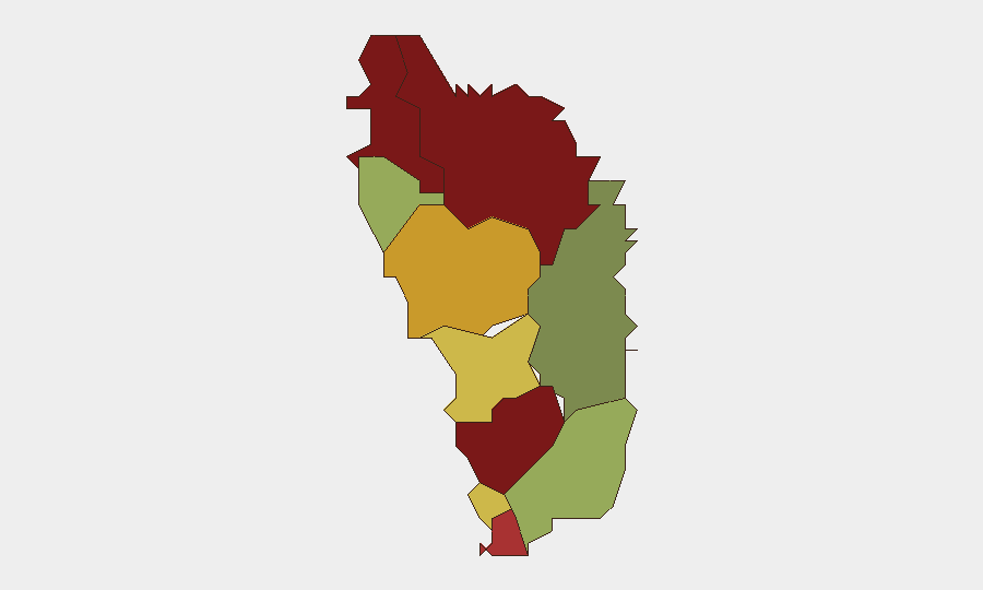
Situation Summary
Dominica remains a low-threat environment with a composite threat score of 3 globally. Open-source monitoring over the last 24–48 hours has identified no verified security incidents, civil unrest, crime escalations, political instability, or infrastructure disruptions. Government activity remains focused on routine hurricane-season preparedness and food-security initiatives ahead of the Atlantic hurricane season. The security posture shows no signs of acute deterioration.
Key Developments
- National / Dominica — 2026-06-11 — Government agencies conducting resilience and food-security planning ahead of Atlantic hurricane season; no acute security incidents identified in parallel reporting.
- Dominican Republic (not Dominica) — 2026-06-15 — Separate Dominican Republic diplomatic activity (rejection of Swiss dialogue) recorded in event feeds; not directly applicable to Dominica governance or security.
- Dominican Republic (not Dominica) — 2026-06-14 to 2026-06-15 — Minor seismic activity (M 3.1 earthquake, 46 km NE of Punta Cana) detected in broader Caribbean region; no Dominica-specific structural or casualty impact reported.
- National / Dominica — 2026-06-10 — Open-source sweeps confirmed absence of protests, strikes, violent crime escalations, or transportation disruptions in the 24-hour monitoring window.
- National / Dominica — Status Quo — No verified changes to security posture, rule-of-law environment, or critical infrastructure availability since last reporting cycle.
*Note: Event signals in the data feed contain references to Dominican Republic diplomatic and seismic activity, not Dominica-specific incidents. Dominica-specific verification found no acute security events in the last 48 hours.*
Highest-Risk Areas
Saint Andrew Parish (risk 92), Saint John Parish (risk 88), and Saint George Parish (risk 81) drive the sub-national risk ranking, though the absolute threat levels remain moderate. The concentration of risk in these northwestern and central parishes likely reflects a combination of population density, economic activity, and historical crime patterns rather than acute current instability. The significant drop in risk scores moving southward (Saint David Parish at 35) suggests geographic disparities in crime prevalence or reporting density. Corporate teams with operations or personnel in Saint Andrew and Saint John parishes should maintain standard area-of-interest monitoring and duty-of-care protocols, but no emergency escalation is warranted based on current threat intelligence.
How GeoBit Would Assist
Teams operating in Dominica should deploy AOI Monitoring & Early Warning (persistent watch on Saint Andrew, Saint John, and Saint George parishes with alert thresholds for crime, civil unrest, or infrastructure incidents) and OSINT fusion & corroboration (continuous sweep of local news, government, and social-media channels to validate or refute emerging rumors of unrest or security change). Risk & Threat Assessment modules would support quarterly reassessment of exposure across parishes and update routing recommendations if localized incidents spike. These capabilities enable early detection of deterioration before it affects personnel safety or asset availability.
7-Day Outlook
No significant security deterioration is anticipated over the next seven days. Government attention will remain on hurricane-season readiness; any acute security events would likely appear first in OSINT feeds focused on crime reporting or civil disturbance. Teams should maintain standard monitoring cadence and review hurricane-response protocols in line with regional seasonal risk.
Highest-Risk Areas — Ranked
| # | State / Region | Risk |
|---|---|---|
| 1 | Saint Andrew Parish | 92 |
| 2 | Saint John Parish | 88 |
| 3 | Saint George Parish | 81 |
| 4 | Saint Mark Parish | 78 |
| 5 | Saint Joseph Parish | 72 |
| 6 | Saint Paul Parish | 68 |
| 7 | Saint Luke Parish | 62 |
| 8 | Saint Peter Parish | 55 |
| 9 | Saint Patrick Parish | 48 |
| 10 | Saint David Parish | 35 |
Sources
Previous Daily Briefs
A new Dominica brief is written every day — each with its own risk map and downloadable CSV. Here's the last week; use the calendar to go further back.
📅 Browse every day by calendar →
Highlighted days have a brief. Tap a day for that day's map & analysis, or “csv” for that day's dataset ($5).