Situation Summary
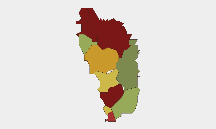
Dominica remains a low-threat environment at global rank #185 with no recorded security incidents in the current reporting week. The country's composite threat score of 4 reflects stable conditions, though sub-national variation is significant: Saint Andrew, Saint John, and Saint George parishes show elevated risk scores (92, 88, and 81 respectively), warranting targeted monitoring for corporate operations in those areas. Near-term trajectory remains stable, anchored by ongoing infrastructure development and official participation in regional security dialogue.
Key Developments
- Wesley, 16 October 2026: International airport construction continues on schedule toward a 2028 opening; no disruptions or security concerns reported. This development will enhance connectivity for business travel and cargo operations.
- Washington, D.C., 15 October 2026: Prime Minister Roosevelt Skerrit participated in the U.S.–Caribbean Dialogue, where regional priorities including illicit firearms trafficking, transnational organized crime, energy security, infrastructure resilience, and disaster preparedness were addressed. Participation signals official engagement with regional security frameworks.
- Bell Hall (near Portsmouth), 19 October 2026: Port Cabrits superyacht marina construction progresses toward planned 2027 opening; no operational disruptions noted. Development reflects tourism-sector expansion.
- No discrete crime, protest, civil unrest, or infrastructure disruption events were confirmed in Dominica during 14–20 October 2026.
Highest-Risk Areas
Saint Andrew Parish (risk score 92), Saint John Parish (88), and Saint George Parish (81) account for the highest sub-national concentration of risk. These three parishes together represent the primary focus areas for security teams with personnel or assets in Dominica. The risk gradient—dropping to 55 or below in southern parishes (Saint Peter, Patrick, David)—suggests that northern and central administrative zones warrant elevated vigilance and contingency planning, though the absolute risk level across all parishes remains low relative to global norms. The drivers of this sub-national differentiation are not specified in current available intelligence; specialized AOI monitoring and local network analysis may clarify underlying factors.
How GeoBit Would Assist
Security teams operating in Dominica should deploy AOI Monitoring & Early Warning focused on Saint Andrew, Saint John, and Saint George parishes to detect emerging incidents or anomalies before escalation. Network & Actor Analysis combined with OSINT fusion (Intel Sweep, X/Twitter & Telegram monitoring, multi-language search) would provide continuous low-level intelligence collection on organized crime, trafficking networks, and protest activity—areas flagged in the U.S.–Caribbean Dialogue. GIS & Spatial Analysis linked to infrastructure tracking (airports, ports, roads) supports route planning and contingency transit options if port or airport disruptions occur.
7-Day Outlook
No credible threat indicators suggest deterioration in the security environment over the next seven days. Ongoing infrastructure projects and stable governance provide continuity. Corporate security teams should maintain routine monitoring of northern parishes while continuing normal operations; no escalation of travel restrictions or asset-protection measures is warranted at this time.
Highest-Risk Areas — Ranked
| # | State / Region | Risk |
|---|---|---|
| 1 | Saint Andrew Parish | 92 |
| 2 | Saint John Parish | 88 |
| 3 | Saint George Parish | 81 |
| 4 | Saint Mark Parish | 78 |
| 5 | Saint Joseph Parish | 72 |
| 6 | Saint Paul Parish | 68 |
| 7 | Saint Luke Parish | 62 |
| 8 | Saint Peter Parish | 55 |
| 9 | Saint Patrick Parish | 48 |
| 10 | Saint David Parish | 35 |
Sources
Previous Weekly Briefs
A new Dominica brief is written every Monday, covering the week — each with its own risk map and downloadable CSV. Use the calendar to go further back.
- October 13, 2026
- October 6, 2026
- September 29, 2026
- September 22, 2026
- September 15, 2026
- September 8, 2026
- September 2, 2026
📅 Browse past briefs by calendar →
Highlighted days have a brief. Tap a day for that day's map & analysis, or “csv” for that day's dataset ($5).
Atlas — our AI intelligence desk — emails them this snapshot personally. Nothing else, no list.