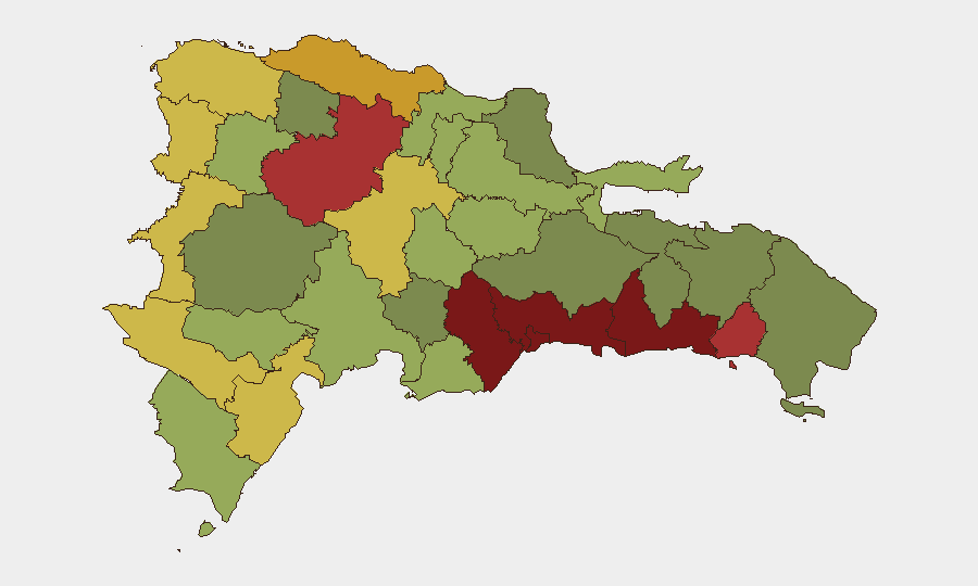
Situation Summary
Dominican Republic remains a moderate-risk operating environment with a composite threat score placing it at #74 globally. Open-source monitoring over the past 24–48 hours shows no confirmed new security incidents, civil unrest, infrastructure disruptions, or high-impact crime events reaching reporting threshold. Routine urban crime continues in high-density areas, particularly Santo Domingo and Nacional District, but the near-term trajectory remains stable absent new triggering events.
Key Developments
- No major incidents confirmed (24–48h window). Commercial risk-intelligence feeds, Dominican news outlets, and international wire services have not published credible, time-stamped reports of new shootings, protests, roadblocks, or political unrest affecting Dominican Republic on 13–14 June 2026. The security environment reflects background conditions rather than active escalation.
- Tourist zones report routine conditions. Anecdotal social-media commentary from Punta Cana and resort areas within the last 24 hours describes subjective safety perceptions aligned with standard precautions (e.g., avoiding jewelry displays, compliance with robbery, resort security protocols). No new incident spike is evident.
- Event signals reflect international actors, not domestic incidents. GEOBIT event tracking shows recent signals dominated by UK, Brazilian, and Scottish entities rather than Dominican security flashpoints, indicating no major domestic crisis dominating intelligence feeds at present.
Highest-Risk Areas
Santo Domingo (risk 92) and Nacional District (risk 88) drive the country's composite threat score, driven by population density, informal-settlement gang presence, and concentrated commercial/logistics activity. San Cristóbal (85), San Pedro de Macorís (83), and La Romana (78) follow, reflecting similar urban crime and narcotics-trafficking exposure along transport corridors and port facilities. Santiago (76) and Puerto Plata (72) maintain elevated risk linked to trafficking routes and organized-crime activity. Border regions (Elías Piña, Dajabón, Independencia) show sustained moderate risk tied to irregular migration and contraband flows. Organizations with personnel or assets in the top six provinces should maintain heightened situational awareness; lower-ranked areas permit standard precautions.
How GeoBit Would Assist
Security teams operating in Dominican Republic should deploy AOI Monitoring & Early Warning on high-risk provinces (Santo Domingo, Nacional District, San Cristóbal, San Pedro de Macorís) to receive automated alerts on protest activity, roadblocks, or gang-related incidents before they impact travel or facility operations. OSINT fusion and multi-language search (including Telegram, X, and local news sources) enable real-time tracking of organized-crime signals, migrant-flow changes, and political developments that may not yet appear in English-language wires. Routing & Network Analysis supports alternative journey planning for staff and supply chains, particularly through interior provinces where gang activity may disrupt primary corridors.
7-Day Outlook
Near-term outlook remains stable, with no indicators of imminent political instability, major civil unrest, or organized-crime escalation. Routine urban crime will persist in Santo Domingo and Nacional District; border regions will continue managing irregular migration and contraband activity. Security posture should remain at present levels absent new triggering events (e.g., large-scale arrest operations, political demonstrations, or gang violence spike), which would be flagged within 2–4 hours of confirmation via GEOBIT event feeds.
Highest-Risk Areas — Ranked
| # | State / Region | Risk |
|---|---|---|
| 1 | Santo Domingo | 92 |
| 2 | Nacional District | 88 |
| 3 | San Cristóbal | 85 |
| 4 | San Pedro de Macorís | 83 |
| 5 | La Romana | 78 |
| 6 | Santiago | 76 |
| 7 | Puerto Plata | 72 |
| 8 | Elías Piña | 70 |
| 9 | Dajabón | 68 |
| 10 | Barahona | 65 |
| 11 | Independencia Province | 64 |
| 12 | La Vega | 62 |
Sources
Previous Daily Briefs
A new Dominican Republic brief is written every day — each with its own risk map and downloadable CSV. Here's the last week; use the calendar to go further back.
📅 Browse every day by calendar →
Highlighted days have a brief. Tap a day for that day's map & analysis, or “csv” for that day's dataset ($5).