Daily Security Brief

Uruguay

July 17, 2026GeoBit Threat Rank #132 · Score 6
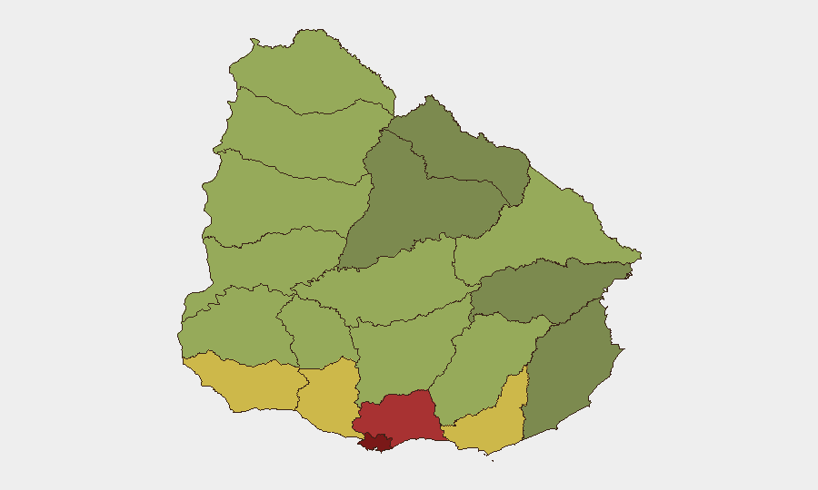
Uruguay sub-national risk map
Sub-national composite risk — darker = higher. Source: GeoBit.
⬇ Uruguay dataset (CSV) — events, per-region risk, cyber & sources

Situation Summary

Uruguay maintains its position as one of the Western Hemisphere's lower-risk states, with no confirmed acute security incidents, civil unrest, or major crime events reported in the last 24–48 hours. The national composite threat score of 6 and global ranking (#132) reflect stable baseline conditions, though structural risks—organized crime, trafficking, and homicide concentrations—remain embedded in specific urban and border departments. Weather alerts for heavy rain and storms from 16 July onward are being monitored, but no storm-related infrastructure or safety incidents have yet materialized.

Key Developments

Arrest/detain event reported in criminal context; details limited in open-source feeds. No indication of mass disturbance or security service disruption.

Arrest/detain signal noted; context and scale unclear from available reporting. No confirmed riot, escape, or large-scale incident at this time.

Uruguay reduced diplomatic relations with Venezuela (16 July); US public statement issued (17 July). Both align with broader hemispheric posture shifts; no domestic security impact detected.

Public statement exchange between Uruguay and Holy See reported; diplomatic in nature, no operational security implication.

Small-arms combat event linked to newspaper operation; limited detail available. Requires monitoring for gang/criminal nexus or journalist-safety escalation.

Strong storms and heavy rain forecast across Uruguay. Risk of localized flooding, road disruption, and power outages, but no confirmed damage or emergency response events as of 17 July 18:00 UTC.

Highest-Risk Areas

Montevideo (risk 92) dominates the national threat profile, driven by homicide density, organized-crime territorial disputes, and trafficking hubs in peripheral barrios. The Canelones (78) and Maldonado (68) departments follow, reflecting spillover gang activity, port-related smuggling, and cross-border criminal networks. San José, Colonia, and Soriano departments (64, 62, 58 respectively) face elevated risk from narcotics trafficking corridors and informal settlements. All other departments score below 60, indicating significantly lower acute threat levels but ongoing baseline organized-crime presence in border regions (Salto, Artigas, Paysandú).

How GeoBit Would Assist

Security teams with personnel or assets in Montevideo and border departments would use Intel Sweep and multi-language OSINT fusion to track gang territorial shifts and trafficking corridor activity in real time. AOI Monitoring & Early Warning on Montevideo's highest-risk barrios, port zones, and cross-border checkpoints would provide persistent alerting for escalations in homicide patterns, organized-crime confrontations, or labor disruptions. GIS & Spatial Analysis combined with Routing & Network Analysis would enable alternative journey planning around crime hotspots and weather-affected zones, supporting duty-of-care protocols for staff movement.

7-Day Outlook

No significant deterioration in the national security baseline is forecast over the next seven days. Weather impacts (rain, localized flooding) are the primary near-term operational risk and should be factored into travel and logistics planning. Structural crime and trafficking activity will continue at baseline levels; diplomatic shifts with Venezuela and the US are unlikely to generate domestic instability. Continued monitoring of the prison and criminal-justice events is warranted to exclude any gang-related escalation or security-service disruption.

Highest-Risk Areas — Ranked

#State / RegionRisk
1Montevideo92
2Canelones78
3Maldonado68
4San José64
5Colonia62
6Soriano58
7Río Negro56
8Salto54
9Artigas52
10Paysandú50
11Florida48
12Flores46

Previous Daily Briefs

A new Uruguay brief is written every day — each with its own risk map and downloadable CSV. Here's the last week; use the calendar to go further back.

📅 Browse every day by calendar →

Highlighted days have a brief. Tap a day for that day's map & analysis, or “csv” for that day's dataset ($5).

June 2026
SMTWTFS
123456789101112131415161718192021222324252627282930
July 2026
SMTWTFS
12345678910111213141516171819202122232425262728293031
⬇ Download PDF
See Uruguay live.
GeoBit maps Uruguay — every region, event, and risk layer — on demand.
Request a live demo →
Share this intelligence
X LinkedIn Reddit Facebook WhatsApp Telegram Email Copy link

Atlas — our AI intelligence desk — emails them this snapshot personally. Nothing else, no list.

Automated by GeoBit AI from publicly reported events and open-source research. Context only; not a risk advisory. Recognized by Deloitte · NVIDIA Inception · Geospatial World Forum.

Email me the brief

Enter your email — we'll send it over.