Situation Summary
East Timor remains a low-threat operating environment by global standards (composite threat score 2; no tracked active incidents). No verified security, civil-unrest, crime, or infrastructure disruptions have been confirmed in the past 24–48 hours across the country. The security posture reflects a stable baseline, though sub-national variation exists, with capital-region and western districts carrying elevated operational risk compared to eastern and southern zones.
Key Developments
No qualifying security, conflict, civil-unrest, or critical infrastructure incidents were verified in East Timor during the last 24–48 hours. Available web research yielded no cross-confirmed recent event reports meeting current recency thresholds for this brief.
*Note: A single public statement from Tokelau (an unrelated Pacific territory) appears in event signals but does not pertain to East Timor security.*
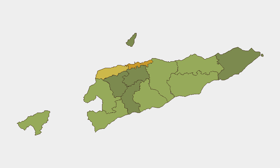
Highest-Risk Areas
Dili (risk 72) dominates the sub-national ranking, reflecting the capital's concentration of government, commerce, diplomatic presence, and—by extension—criminal and civil-order risk factors typical of major urban centers. Liquiçá (62) and Baucau (58) follow, suggesting friction points in the western border zone and eastern population center. Mid-tier risk in Cova Lima and Bobonaro (both western districts) likely reflects cross-border dynamics and historical communal tensions. Rural and southern regions (Aileu, Ermera, Ainaro) report substantially lower scores, indicating sparser incident prevalence and lower operational exposure for corporate assets.
How GeoBit Would Assist
Security teams operating in East Timor should employ AOI Monitoring & Early Warning to establish persistent watch on Dili's diplomatic, port, and commercial districts, with alert thresholds for civil unrest or crime-cluster escalation. Intel Sweep and multi-language OSINT (X/Twitter, Telegram, local news sources) should form the backbone of a weekly or real-time feed to catch emerging unrest, labor action, or political instability before mainstream reporting. Network & Actor Analysis would support vetting of local security contractors, vendors, and transport partners, particularly in higher-risk zones, and Routing & Network Analysis would enable pre-planned alternative mobility corridors in the event of port closures, roadblocks, or civil demonstrations affecting primary routes.
7-Day Outlook
No imminent security escalation is forecasted. The country's baseline stability is expected to persist; however, monitoring for seasonal labor disputes, local political developments, and cross-border movement in western districts should remain routine. Personnel and asset movements in Dili should continue to observe standard corporate due diligence and situational awareness protocols, particularly during evening and weekend hours.
Next Update: 2026-06-12, 06:00 UTC
Contact: GeoBit Analyst, East Timor Desk
Highest-Risk Areas — Ranked
| # | State / Region | Risk |
|---|---|---|
| 1 | Dili | 72 |
| 2 | Liquiçá | 62 |
| 3 | Baucau | 58 |
| 4 | Cova Lima | 55 |
| 5 | Bobonaro | 53 |
| 6 | Oecussi-Ambeno | 48 |
| 7 | Manufahi | 45 |
| 8 | Viqueque | 42 |
| 9 | Manatuto | 40 |
| 10 | Ainaro | 38 |
| 11 | Ermera | 36 |
| 12 | Aileu | 32 |
Sources
Previous Daily Briefs
A new East Timor brief is written every day — each with its own risk map and downloadable CSV. Here's the last week; use the calendar to go further back.
📅 Browse every day by calendar →
Highlighted days have a brief. Tap a day for that day's map & analysis, or “csv” for that day's dataset ($5).