ملخص الحالة
تيمور الشرقية تبقى بيئة منخفضة التهديد حسب المعايير العالمية (درجة التهديد المركبة 2)، مع عدم وجود حوادث أمنية موثوقة ومؤكدة بشكل مستقل، أو اضطرابات مدنية، أو اضطرابات في البنية التحتية تم الإبلاغ عنها في آخر 24-48 ساعة. يهيمن على الملف الأمني للدولة التباين دون الوطني، حيث تشهد ديلي وليكويسا تعرضاً مرتفعاً نسبياً مقارنة بالمناطق النائية. يشير غياب الحوادث الجديرة بالإبلاغ عنها إلى استقرار الظروف الأساسية، رغم أن الجريمة المحلية المستمرة وآليات حل النزاعات غير الرسمية تبقى عوامل كامنة في المناطق الأكثر خطورة.
التطورات الرئيسية
- لم يتم تأكيد حوادث جديرة بالإبلاغ عنها في آخر 24-48 ساعة من مصادر مفتوحة موثوقة. لم يسفر البحث على الويب ومراقبة منصة إكس/تويتر وخلاصات الأخبار الدولية عن أي أحداث أمنية قابلة للتحقق وموثقة بالوقت، أو اضطرابات مدنية، أو طفرات إجرامية، أو عدم استقرار سياسي، أو اضطرابات في البنية التحتية ضمن إقليم تيمور الشرقية خلال هذه الفترة.
- ركزت التغطية الإعلامية الدولية الأخيرة لتيمور-ليست على النشاط الدبلوماسي (تعاون الأمن بين آسيان وروسيا) بدلاً من الحوادث المحلية، مما يشير إلى عدم وجود إشارات تصعيد سياسي أو إقليمي حاد.
- الإقرارات الجاهزة بشأن الأمن والنزاعات التي تظهر في شروط الخدمة العامة للسياحة والفعاليات لا تعكس الظروف الحالية الفعلية في تيمور الشرقية وتُعزى إلى ممارسات توليد المحتوى الآلي بدلاً من التهديدات الموضوعية.
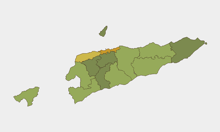
أعلى المناطق الخطرة
ديلي (درجة خطر 72) وليكويسا (درجة خطر 62) تقودان الملف الأمني الوطني، تليهما باوكاو (58) وكوفا ليما (55). يعكس التركز الحضري—لا سيما العاصمة—عادة تعرضاً أعلى للجريمة الصغيرة وضعف التجمعات غير الرسمية وكثافة الإبلاغ عن الحوادث الأكبر. يعكس ترتيب ليكويسا المرتفع الأنشطة العصابية التاريخية والنزاعات بين المجتمعات؛ المناطق النائية (إيليو وإيرميرا وإينارو) تحمل درجات مركبة أقل بشكل جوهري، مما يشير إلى تهديدات موثقة أقل وتعقيد تشغيلي أقل للوجود الشركاتي. تدرج الخطر متسق مع مسار الانتقال ما بعد الصراع في تيمور الشرقية ويعكس أنماط الجريمة والتماسك الاجتماعي بدلاً من الصراع المسلح النشط.
كيف ستساعد GeoBit
Intel Sweep والمخابرات من مصادر مفتوحة متعددة اللغات (بما في ذلك الإعلام المحلي ومراقبة الإشارات الإذاعية وراقبة تطبيق تيليجرام) ستوفر إنذاراً مبكراً مستمراً وفي الوقت الفعلي للحوادث الناشئة وإشارات الاضطرابات المدنية أو أنماط الجريمة قبل تطورها إلى تهديدات على مستوى الشركات. مراقبة منطقة الاهتمام والإنذار المبكر المعدة لديلي وليكويسا والمناطق عالية الخطورة الأخرى ستنبه فريق الأمن إلى نشاط الشرطة وأنشطة الاحتجاج أو اضطرابات البنية التحتية في اللحظة التي يظهر فيها الإبلاغ، مما يتيح استجابة سريعة لالتزامات العناية الواجبة. تحليل نظم المعلومات الجغرافية والتحليل المكاني مقترناً بتحليل التوجيه والشبكات سيدعم التخطيط الآمن للسفر وتقييم مخاطر المواقع وتحديد المسارات البديلة لحركة الموظفين والأصول في المناطق عالية الخطورة.
التوقعات لمدة 7 أيام
لا توجد إشارات تصعيد فورية واضحة من المصادر المفتوحة المتاحة. من المتوقع أن يستمر الاستقرار الأساسي على مدى الأسبوع القادم، رغم أن الجريمة الصغيرة المحلية والنزاعات بين المجتمعات والعنف غير الرسمي في المناطق الحضرية وشبه الحضرية تبقى متوطنة ويجب افتراضها كسياق تشغيلي. يُنصح بالمراقبة المستمرة عبر المخابرات من مصادر مفتوحة والخلاصات المحلية لكشف التحولات المبكرة في نشاط الشرطة أو الإدلاء بتصريحات سياسية أو مؤشرات الجريمة المنظمة.
المناطق الأعلى خطورة — مرتبة
| # | الولاية / المنطقة | الخطر |
|---|---|---|
| 1 | Dili | 72 |
| 2 | Liquiçá | 62 |
| 3 | Baucau | 58 |
| 4 | Cova Lima | 55 |
| 5 | Bobonaro | 53 |
| 6 | Oecussi-Ambeno | 48 |
| 7 | Manufahi | 45 |
| 8 | Viqueque | 42 |
| 9 | Manatuto | 40 |
| 10 | Ainaro | 38 |
| 11 | Ermera | 36 |
| 12 | Aileu | 32 |
المصادر
الموجزات اليومية السابقة
يُنشر موجز جديد عن East Timor كل يوم — لكل منها خريطة مخاطر وملف CSV قابل للتنزيل. هذا هو الأسبوع الأخير؛ استخدم التقويم للرجوع أبعد.
📅 Browse every day by calendar →
Highlighted days have a brief. Tap a day for that day's map & analysis, or “csv” for that day's dataset ($5).