Situation Summary
Ecuador remains ranked #31 globally with a composite threat score of 36, driven by persistent organized-crime violence, cross-border narcotrafficking, and state fragmentation particularly in coastal and Amazonian provinces. The past 48 hours show elevated political and military signaling—including multiple government disapprovals, military force deployments, and a presidential rejection—alongside ongoing criminal activity in the country's highest-risk zones. Four provinces (Guayas, Los Ríos, El Oro, Manabí) are under formal state of emergency with a 37% increase in homicides. The security trajectory remains unstable, with no clear de-escalation in sight.
Key Developments
- Guayaquil (Guayas) & Durán – Persistent Level 4 "Do Not Travel" designation. Southern Guayaquil and Durán canton remain epicenters of gang-driven violence, kidnapping, and terrorism. U.S. State Department maintains highest-level travel warnings for these areas due to entrenched criminal organizations and frequency of brutal incidents.
- Esmeraldas City & northern border corridor (Esmeraldas/Carchi) – Cross-border armed-group activity. Terrorism and organized-crime violence linked to Colombian armed groups and narcotrafficking operations continue to destabilize this region. All areas north toward the Colombian border are designated "Do Not Travel."
- El Oro Province (Huaquillas, Arenillas) – Transnational criminal organization (TCO) control. Border towns remain hotspots for violent crime and terrorism tied to Peru-Ecuador trafficking routes. Armed robbery, extortion, and kidnapping are endemic.
- Coastal provinces (Manabí, Esmeraldas, El Oro, Guayas) – Massacre and cartel concentration. These provinces account for the majority of recent mass-casualty incidents and cocaine-transit violence, reflecting their strategic importance to regional narcotrafficking networks.
- Nationwide urban centers – Armed robbery and home invasion risk. Quito, Guayaquil, and Cuenca all report elevated incidence of armed robbery, gunpoint assault, and home invasions targeting both residents and foreigners.
- Political & military signaling (2026-06-01/02). Recent government statements, military force deployments, and presidential statements suggest internal political tension or institutional friction that may complicate crisis response or governance stability.
Highest-Risk Areas
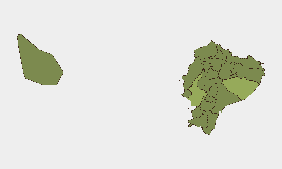
Pastaza Province (55.2) and Guayas Province (50.4) dominate the risk ranking, with Pichincha (31.6) trailing significantly. Guayas—home to Ecuador's largest city and primary port—faces the convergence of gang violence, state-of-emergency conditions, and terrorist designation in key urban zones. Pastaza's elevated score reflects Amazonian instability, indigenous-community tensions, and cross-border spillover from Peru and Colombia. Coastal provinces collectively (Guayas, Manabí, El Oro, Esmeraldas) are the primary drivers of national homicide rates and cartel activity. Pichincha, containing the capital Quito, shows lower relative risk but remains vulnerable to armed robbery and organized crime in specific urban neighborhoods.
How GeoBit Would Assist
Security teams with personnel or assets in Ecuador should employ AOI Monitoring & Early Warning to track high-risk provinces in near-real time, coupled with OSINT fusion & corroboration (X/Twitter, Telegram, open-source incident reporting) to detect emerging threats in provincial hotspots before they escalate. Routing & Network Analysis can identify safer transit corridors and alternative supply-chain paths around declared "Do Not Travel" zones. Risk & Threat Assessment combined with sentiment & temporal analysis on government and military communications can signal political instability or security-force restructuring that affects duty-of-care decision-making.
7-Day Outlook
No major nationwide incident is documented in the last 24 hours, but the underlying risk landscape—state-of-emergency conditions, elevated homicide rates, and recent political/military signaling—suggests continued volatility. Organizations should maintain heightened vigilance in Guayas, Esmeraldas, and El Oro while monitoring Pichincha for secondary effects of any capital-level political friction. Coastal and border-zone violence is expected to remain endemic absent major security-force intervention.
Highest-Risk Areas — Ranked
| # | State / Region | Risk |
|---|---|---|
| 1 | Pastaza Province | 55.2 |
| 2 | Guayas Province | 50.4 |
| 3 | Pichincha Province | 31.6 |
| 4 | Napo Province | 29.5 |
| 5 | Manabí Province | 26.8 |
| 6 | Tungurahua Province | 26.3 |
| 7 | Sucumbíos Province | 25.2 |
| 8 | Orellana Province | 25.2 |
| 9 | Galápagos | 25.2 |
| 10 | Esmeraldas Province | 25.2 |
| 11 | Carchi Province | 25.2 |
| 12 | Imbabura Province | 25.2 |
Sources
Previous Daily Briefs
A new Ecuador brief is written every day — each with its own risk map and downloadable CSV. Here's the last week; use the calendar to go further back.
📅 Browse every day by calendar →
Highlighted days have a brief. Tap a day for that day's map & analysis, or “csv” for that day's dataset ($5).