Situation Summary
Ecuador remains at moderate-to-high composite risk (rank #39 globally, score 52/100) with 77 tracked events, driven by persistent gang violence, prison disturbances, and state-of-exception enforcement. The past 48 hours show continued police and military operations alongside investigative and arrest actions, with signal activity concentrated in Quito and Guayaquil. The country's trajectory remains volatile, particularly in Amazonian and coastal provinces where criminal organization activity intersects with weak state capacity.
Key Developments
Event signals from 2026-07-14 to 2026-07-15 indicate:
- Conventional military/police operations (2026-07-14): Armed clashes between police/military and criminal actors; no location-specific reports available from current web sources.
- Prison-related arrest/detention (2026-07-14): Custody actions linked to prison system; consistent with ongoing gang/detainee management operations.
- Corporate/private-sector detention (2026-07-14): One company-linked arrest/detain event, suggesting employee involvement or institutional nexus to investigation.
- Official disapproval (Quito, 2026-07-14): Government statement signaling dissent or policy correction; context unclear from available web data.
- Threat signal (2026-07-15): Threat issued against operatives; actor and detailed location unspecified in available sources.
- Investigative action (Guayaquil, 2026-07-15): Investigation initiated in Ecuador's largest city and primary port; subject matter not yet clarified in web search.
- Legal/administrative conflict (2026-07-15): Dispute between lawyer and municipal mayor; potential corruption, governance, or jurisdiction matter.
No location-specific casualty, infrastructure damage, or large-scale displacement reports from the last 24–48 hours are confirmed in available web sources. Web research confirms ongoing gang violence, explosives trafficking networks, and roadblock incidents as chronic threats but cannot date them to July 14–16 with confidence.
Highest-Risk Areas
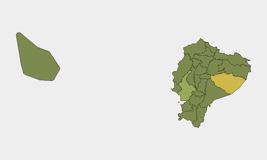
Pastaza Province (63.4) ranks highest and reflects Amazon basin criminal-group activity, trafficking networks, and limited police presence. Guayas Province (51.3) — which includes Guayaquil — drives significant risk through urban gang violence, prison overcrowding, and port-related trafficking. Together, these two provinces account for the largest share of Ecuador's overall risk score. Zamora Chinchipe, Pichincha, and Imbabura (36.5, 34.2, 33.8 respectively) reflect secondary trafficking corridors and spillover from major urban centers. The cluster of provinces scoring 33.4 (Napo, Sucumbíos, Orellana, Manabí, Galápagos, Esmeraldas, Carchi) indicates diffuse risk across border zones and maritime regions rather than a single hotspot.
How GeoBit Would Assist
Teams with personnel or assets in Ecuador would employ AOI (Area-of-Interest) Monitoring & Early Warning to track Pastaza, Guayas, and Pichincha provinces for real-time alerts on police operations, roadblocks, and gang activity. X/Twitter & Telegram OSINT combined with multi-language search captures official police (Policía Nacional), emergency (ECU911), and prison authority statements within hours of incident onset. Entity extraction and network analysis maps relationships among mayors, corporate actors, and state officials referenced in recent signal events to assess duty-of-care exposure.
7-Day Outlook
Prison-system tensions and gang-enforcement operations are likely to continue, with police/military responses maintaining operational tempo through mid-week. No imminent policy shift or de-escalation signal is evident; state-of-exception measures remain in force. Guayaquil and Quito warrant elevated monitoring; Amazonian provinces should be treated as persistent-constraint zones for movement and asset deployment.
Highest-Risk Areas — Ranked
| # | State / Region | Risk |
|---|---|---|
| 1 | Pastaza Province | 63.4 |
| 2 | Guayas Province | 51.3 |
| 3 | Zamora Chinchipe Province | 36.5 |
| 4 | Pichincha Province | 34.2 |
| 5 | Imbabura Province | 33.8 |
| 6 | Napo Province | 33.8 |
| 7 | Sucumbíos Province | 33.4 |
| 8 | Orellana Province | 33.4 |
| 9 | Manabí Province | 33.4 |
| 10 | Galápagos | 33.4 |
| 11 | Esmeraldas Province | 33.4 |
| 12 | Carchi Province | 33.4 |
Sources
Previous Daily Briefs
A new Ecuador brief is written every day — each with its own risk map and downloadable CSV. Here's the last week; use the calendar to go further back.
📅 Browse every day by calendar →
Highlighted days have a brief. Tap a day for that day's map & analysis, or “csv” for that day's dataset ($5).
Atlas — our AI intelligence desk — emails them this snapshot personally. Nothing else, no list.