Situation Summary
Eritrea remains a high-structural-risk environment characterized by chronic governance constraints, human-rights restrictions, and regional instability—but no acute security incidents have been independently confirmed in the past 24–48 hours. The country's composite threat score remains low (2), reflecting the absence of tracked discrete events, while sub-national risk is heavily concentrated in border and western regions (Gash-Barka and Southern Red Sea Region). The underlying threat posture is driven by long-standing political repression, indefinite military service, arbitrary detention, and Red Sea maritime tensions rather than by new destabilizing events.
Key Developments
No discrete, independently corroborated security or infrastructure incidents inside Eritrea were identified in the last 24–48 hours across open-source news, institutional reporting, or social-media channels. Structural risk factors—including UN-documented human-rights concerns and regional Horn of Africa tensions—remain active but represent *continuing conditions* rather than new developments. Teams should monitor indirect threats from Ethiopian and Red Sea maritime activity (see 7-Day Outlook), as these can create secondary impacts on Eritrean ports and trade routes.
Highest-Risk Areas
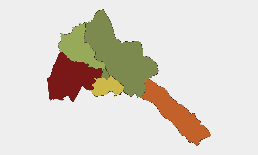
Gash-Barka (western region, risk score 92) and the Southern Red Sea Region (risk score 75) drive the country's composite risk profile. Gash-Barka borders Sudan and Ethiopia; it is exposed to cross-border trafficking, militia activity, and residual conflict spillover from the broader Horn of Africa. The Southern Red Sea Region faces maritime-security risks, including irregular migration, smuggling networks, and geopolitical tensions over sea access and regional shipping corridors. By contrast, Maekel Region (capital area, Asmara, risk score 18) and the Northern Red Sea (risk score 0) reflect lower operational threat, though political surveillance and movement restrictions apply nationwide.
How GeoBit Would Assist
Intel Sweep & OSINT Fusion would detect emerging political, protest, or cross-border events through multi-language news monitoring, social-media sentiment analysis, and radio SIGINT to surface early warnings missed by English-language reporting. AOI Monitoring & Early Warning capabilities would enable persistent watch on Gash-Barka and Southern Red Sea Region, alerting teams to trafficking surges, militia movements, or maritime incidents affecting supply chains or personnel safety. Routing & Network Analysis would support duty-of-care teams in identifying alternative travel corridors and supply-chain resilience if Red Sea or border-zone security deteriorates; GIS & Spatial Analysis would map secure zones and cross-border risk corridors for operational planning.
7-Day Outlook
No imminent acute security events are forecast for Eritrea proper in the next 7 days. However, teams should monitor spillover from Ethiopian regional tensions, potential Red Sea shipping disruptions, and any escalation in irregular-migration or smuggling activity in Gash-Barka. Structural constraints on freedom of movement, telecommunications, and reporting will continue to limit real-time visibility; organizations should rely on forward-deployed personnel, regional liaison networks, and satellite/imagery monitoring for early warning of instability that may not appear in public reporting.
Highest-Risk Areas — Ranked
| # | State / Region | Risk |
|---|---|---|
| 1 | Gash-Barka | 92 |
| 2 | Southern Red Sea Region | 75 |
| 3 | Debub Region | 68 |
| 4 | Anseba | 55 |
| 5 | Maekel Region | 18 |
| 6 | Northen Red Sea Region | 0 |
Sources
Previous Daily Briefs
A new Eritrea brief is written every day — each with its own risk map and downloadable CSV. Here's the last week; use the calendar to go further back.
📅 Browse every day by calendar →
Highlighted days have a brief. Tap a day for that day's map & analysis, or “csv” for that day's dataset ($5).