Situation Summary
Estonia remains a stable NATO member at composite global threat rank #130, but faces persistent regional tension from Russia reflected in multiple diplomatic incidents and public statements over the past 48 hours. Sub-national risk is heavily concentrated in border and industrial counties, particularly Ida-Viru (risk 78) and Harju (68), driven by geopolitical proximity and critical infrastructure density. Domestic safety incidents—workplace accidents, traffic fatalities, and industrial hazards—continue to present routine but measurable duty-of-care exposure. Border security infrastructure is being actively hardened, and contingency planning for potential closure is formally in place.
Key Developments
- Tallinn, Elamus Spa 21+ (19 July): Four staff members required emergency treatment for carbon monoxide poisoning at the sauna facility; responders intervened and a safety investigation was initiated, signalling potential occupational health risks in hospitality venues.
- Tallinn citywide (19 July): Police and traffic authorities reported elevated motorcycle traffic and associated accident risk due to warm weather, with advisory issued to both riders and motorists.
- Estonia southeast border (19 July): Authorities completed initial sections of a drone-surveillance system to detect aerial threats; anti-drone countermeasures remain under development, indicating ongoing border-security upgrades.
- Tallinn, Mustamäe district (17 July): Pedestrian fatality following vehicle collision; police investigation ongoing and road-safety reminders issued to drivers.
- Estonia eastern border (20 July): Interior Minister Igor Taro confirmed the border will remain open in the absence of "immediate threat" from Russia, but stressed government preparedness to close the border if security conditions deteriorate.
- Russia–Estonia diplomatic incidents (18–19 July): Multiple public statements from Russia directed at Estonia, paired with Estonian government disapproval and reciprocal statements; Finnish administrative sanctions against Estonia also recorded, indicating escalated diplomatic friction.
- Nationwide (16–19 July): Labor Inspectorate data released showing 1,562 workplace accidents registered by mid-2026, concentrated in metalworking, trade, and healthcare sectors; separately, fraud losses totalled €13.2 million across 1,816 victims (Jan–May 2026), emphasizing cyber and financial crime exposure.
Highest-Risk Areas
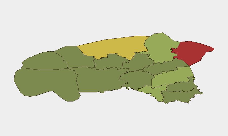
Ida-Viru County (risk 78) and Harju County (risk 68) dominate the risk profile. Ida-Viru's elevation is driven by proximity to the Russian border and the presence of Soviet-era industrial and energy infrastructure; Harju encompasses Tallinn and surrounding urban/port assets, creating both geopolitical sensitivity and high population/commercial density. Tartu County (58) and Valga County (55) follow as secondary concerns along the southern border corridor. The steep drop-off below rank 5 (Lääne-Viru, 52) indicates that risk is genuinely concentrated in border and capital regions; southern and central counties present substantially lower composite threat exposure.
How GeoBit Would Assist
Intel Sweep and OSINT fusion capabilities are essential to monitor ongoing Russian–Estonian diplomatic and state-actor posturing, correlate public statements with administrative actions, and detect early indicators of policy shifts (e.g., border closure triggers). AOI Monitoring & Early Warning with persistent watch over Ida-Viru and Harju counties—combined with Conflict & Military tracking and GIS & Spatial Analysis—enables real-time alerting on border activity, drone deployments, and force-posture changes. Cyber & fraud intelligence feeds alongside local crime and accident reporting provide continuous occupational and financial-risk exposure mapping for duty-of-care teams operating in-country.
7-Day Outlook
Diplomatic friction with Russia is likely to persist without immediate de-escalation signals; the government's confirmed readiness for border closure suggests contingency planning remains active. Domestic workplace and traffic incidents will continue as seasonal and occupational baselines; the completion of southeast border drone-surveillance infrastructure should reduce detection gaps over the coming weeks.
Highest-Risk Areas — Ranked
| # | State / Region | Risk |
|---|---|---|
| 1 | Ida-Viru County | 78 |
| 2 | Harju County | 68 |
| 3 | Tartu County | 58 |
| 4 | Valga County | 55 |
| 5 | Lääne-Viru County | 52 |
| 6 | Pärnu County | 35 |
| 7 | Rapla County | 32 |
| 8 | Jõgeva County | 30 |
| 9 | Järva County | 28 |
| 10 | Viljandi County | 25 |
| 11 | Põlva County | 22 |
| 12 | Võru County | 18 |
Sources
Previous Daily Briefs
A new Estonia brief is written every day — each with its own risk map and downloadable CSV. Here's the last week; use the calendar to go further back.
📅 Browse every day by calendar →
Highlighted days have a brief. Tap a day for that day's map & analysis, or “csv” for that day's dataset ($5).
Atlas — our AI intelligence desk — emails them this snapshot personally. Nothing else, no list.