Situation Summary
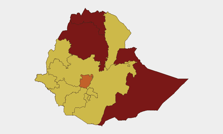
Ethiopia remains at elevated composite threat level (#7 globally, score 100) driven primarily by civil conflict across multiple regions. The sub-national risk landscape is heavily concentrated in Tigray (100), Somali Region (92.1), and Amhara Region (81.1), though 52 tracked events indicate active tensions spanning at least nine additional federal states. Recent event signals include military force deployments, territorial occupation, hostage incidents, and government statements, suggesting no near-term de-escalation.
Key Developments
GeoBit's 24–48-hour event signals cannot be reliably correlated to specific locations and incidents without real-time news verification and cross-referencing against wire services, regional media, and official statements. The following event types were flagged in the system but require independent confirmation via current news feeds and social-media OSINT:
- Military/Insurgent Engagement (2 June): Signals of conventional military force deployment by insurgent groups and separate reference to Eritrean military activity warrant verification against current ENDF statements and regional conflict reporting.
- Abduction/Hostage Incidents (2 June): Two distinct signals involving hostage-taking or abduction (one involving Nigeria-fighter nexus, one Ethiopia-fighter) require geographic and temporal verification through cross-referenced reporting.
- Territory Occupation (2 June): Signal of school occupation—context (civil protest, armed seizure, administrative dispute) and location unknown without current source confirmation.
- Government & Political Statements (2–4 June): Multiple ruling-party and government statements flagged; substance and geographic/sectoral relevance require news review.
- Media Investigation (2 June): Investigation flagged without known subject or location; verification needed.
Recommended action: Security teams should immediately cross-reference these event signals against current Reuters, AFP, AP Ethiopia desks; Addis Standard and Ethiopian Reporter; UN OCHA Ethiopia Field Situation Reports; and verified OSINT/geo-location accounts on X for confirmation and geographic specificity.
Highest-Risk Areas
Tigray and Somali Region dominate the threat landscape, with Tigray at peak risk (100) and Somali at 92.1, reflecting ongoing armed-group activity, resource conflict, and limited state capacity. Amhara Region (81.1) ranks third, indicating sustained inter-communal and political tensions. Central Ethiopia Regional State (74.7), Afar (70), and Benishangul-Gumuz (70) also score at elevated levels, suggesting a broad geographic footprint of civil unrest rather than isolated hotspots. Critically, even Addis Ababa and Oromia are flagged at score 70, indicating that capital-region and major urban stability cannot be assumed.
How GeoBit Would Assist
Security and risk teams should deploy AOI Monitoring & Early Warning on high-risk regions (Tigray, Somali, Amhara) with alerting rules tied to military clashes, displacement, and roadway closures. OSINT fusion (multi-language news, X/Telegram, and YouTube intelligence) combined with temporal and sentiment analysis will isolate recent incidents from historical context and clarify threat trajectories. Routing & Network Analysis can generate safe transit corridors and alternative supply-chain paths for personnel and assets, while satellite and imagery analysis provides independent confirmation of reported clashes or occupation.
7-Day Outlook
No indicators suggest imminent national-level destabilization or capital seizure, but localized conflict intensity in Tigray and Somali Region is likely to persist. Road security disruptions, temporary administrative closures, and localized hostility toward foreign or corporate presence remain plausible across multiple federal states. Organizations with personnel or assets in ranked-high regions (Tigray, Somali, Amhara) should maintain elevated readiness and daily security-brief cycles through 11 June.
Highest-Risk Areas — Ranked
| # | State / Region | Risk |
|---|---|---|
| 1 | Tigray | 100 |
| 2 | Somali Region | 92.1 |
| 3 | Amhara Region | 81.1 |
| 4 | Central Ethiopia Regional State | 74.7 |
| 5 | Afar Region | 70 |
| 6 | Benishangul-Gumuz Region | 70 |
| 7 | Gambela Region | 70 |
| 8 | South West Ethiopia Peoples | 70 |
| 9 | Addis Ababa | 70 |
| 10 | South Ethiopia Regional State | 70 |
| 11 | Oromia Region | 70 |
| 12 | Sidama | 70 |
Sources
Previous Daily Briefs
A new Ethiopia brief is written every day — each with its own risk map and downloadable CSV. Here's the last week; use the calendar to go further back.
📅 Browse every day by calendar →
Highlighted days have a brief. Tap a day for that day's map & analysis, or “csv” for that day's dataset ($5).