Situation Summary
Gabon remains a stable, low-threat environment globally ranked #107 with a composite threat score of 14 across 19 tracked events. No new security or travel-risk incidents have been verified in open sources over the past 24–48 hours; recent activity signals reflect political and government administrative matters rather than civil unrest or criminal escalation. The security posture is driven by baseline conditions in high-risk provinces rather than acute developments.
Key Developments
- 2026-06-17 · Government Disapproval Statement – A government-level disapproval announcement was registered; specific subject and jurisdiction remain under analysis pending official clarification.
- 2026-06-19 · Public Statement (Gabon vs Secretariat) – A public statement concerning a dispute or engagement between Gabon and an unnamed secretariat body was issued; context and operational impact not yet detailed in available sources.
- 2026-06-19 · Police Investigation Notice – A police investigation was initiated; scope, location, and subject classification remain unconfirmed in open-source reporting.
*Note: No discrete criminal, civil-unrest, or infrastructure-disruption incidents with verified timestamps have been confirmed in the last 24–48 hours. The above three signals reflect administrative and governmental activity; their security or operational relevance to corporate assets and personnel requires ongoing monitoring but do not currently indicate heightened field-level risk.*
Highest-Risk Areas
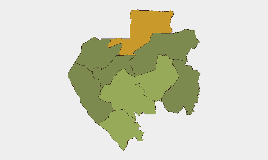
Woleu-Ntem Province (risk score 72) is the primary concern, followed by Ogooué-Lolo (58) and Ngounié (48). These three provinces account for the majority of Gabon's sub-national threat concentration; drivers are not currently specified in available reporting but historically correlate with border proximity, limited state presence, and resource-extraction competition. Estuaire Province, which includes the capital Libreville, maintains a notably lower risk score (15), as do the interior provinces of Ogooué-Ivindo (0). Organizations with personnel or assets in the northern and southeastern interior should apply heightened due diligence; those based in or transiting the capital and coastal zones face baseline risk consistent with Gabon's overall low national profile.
How GeoBit Would Assist
Organizations operating in Gabon should employ AOI (Area-of-Interest) Monitoring & Early Warning on Woleu-Ntem and Ogooué-Lolo provinces to detect any escalation in criminal activity, civil unrest, or border incidents before they affect operations. Intel Sweep and multi-language OSINT fusion (including local news, radio SIGINT, and social-media sentiment analysis) would provide real-time visibility into the three political/administrative signals flagged on June 17–19 and clarify their corporate-security relevance. Routing & Network Analysis can identify safer transit corridors and alternative supply routes should conditions deteriorate in high-risk provinces.
7-Day Outlook
No acute security crisis is forecast over the next seven days. Political administrative activity and the ongoing police investigation warrant continued passive monitoring to rule out downstream escalation, but current indicators do not suggest imminent civil unrest, infrastructure disruption, or violence affecting corporate operations. Baseline vigilance in Woleu-Ntem and Ogooué-Lolo provinces should remain in effect.
Highest-Risk Areas — Ranked
| # | State / Region | Risk |
|---|---|---|
| 1 | Woleu-Ntem | 72 |
| 2 | Ogooué-Lolo Province | 58 |
| 3 | Ngounié Province | 48 |
| 4 | Nyanga Province | 42 |
| 5 | Haut-Ogooué Province | 35 |
| 6 | Moyen-Ogooué Province | 28 |
| 7 | Ogooué-Maritime Province | 25 |
| 8 | Estuaire Province | 15 |
| 9 | Ogooué-Ivindo | 0 |
Sources
Previous Daily Briefs
A new Gabon brief is written every day — each with its own risk map and downloadable CSV. Here's the last week; use the calendar to go further back.
📅 Browse every day by calendar →
Highlighted days have a brief. Tap a day for that day's map & analysis, or “csv” for that day's dataset ($5).