Situation Summary
Haiti remains in acute crisis driven by gang violence and state collapse, with gangs controlling approximately 90% of the capital and security conditions deteriorating across multiple fronts. The composite threat score of 63.1 (rank #23 globally) understates the concentrated severity in Port-au-Prince and Artibonite Department, where armed groups are expanding territorial control, intensifying recruitment of minors, and leveraging sexual violence as a control mechanism. Displacement now exceeds 1.4–1.5 million people, and critical public services—health, water, education, security—are collapsing in gang-affected zones. The trajectory is deterioration: gang coordination is expanding beyond the capital into northern and western corridors, political vacuum persists, and humanitarian access continues to erode.
Key Developments
- Port-au-Prince airport and arterial roads – Ongoing armed gang clashes and blockades disrupting civilian and aid movement; fighting focused on control of state infrastructure and pressure points.
- Cité Soleil and northern Port-au-Prince neighborhoods – Rival gang clashes driving mass displacement into makeshift camps; displacement population now 1.4–1.5 million.
- Forced recruitment of children (nationwide, concentrated in Port-au-Prince and poor districts) – Approximately 50% of gang membership now comprises minors; child recruitment rose ~200% in 2025; abductions and coercion accelerating over recent days.
- Sexual violence as territorial control tactic – Documented 25% year-on-year rise in gender-based violence; 1,000% increase in sexual violence against children since 2023; attacks concentrated in displacement sites and informal settlements.
- Northern and western highway corridors (Artibonite, Nord-Ouest) – Armed groups establishing illegal checkpoints, conducting robberies and kidnappings of travelers; overland movement severely restricted.
- Public services collapse (water, health, education nationwide) – Over one-third of households not treating water; three-quarters unable to afford medical care; six in ten households reporting children not attending school due to kidnapping and recruitment fears.
- Political vacuum and gang territorial dominance – No elected national officials; gangs control ~90% of Port-au-Prince; transitional governance lacks authority to mount coordinated security response.
Highest-Risk Areas
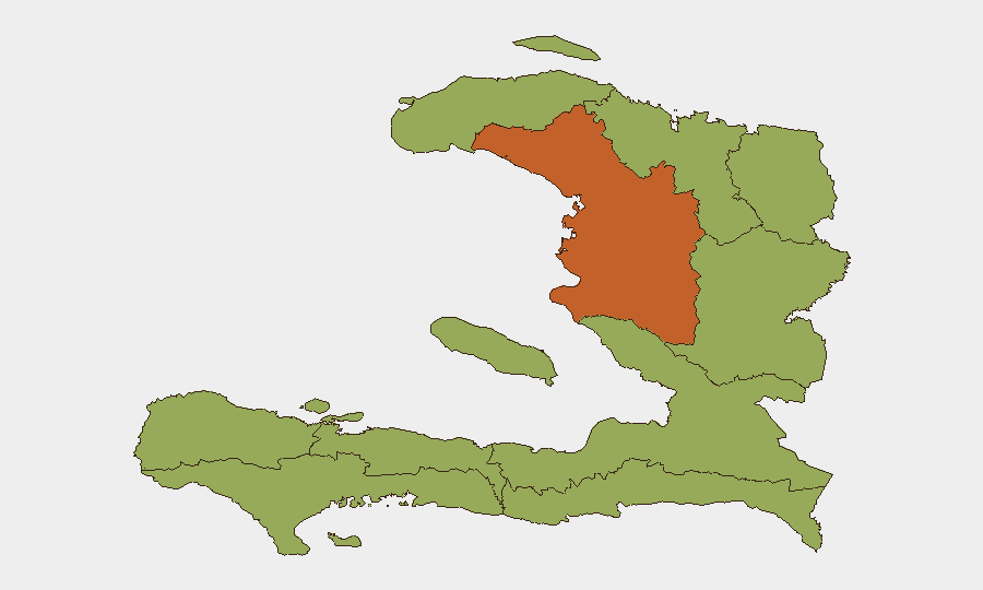
Artibonite Department (risk 74.2) is the primary outlier and driver of sub-national risk, reflecting gang expansion northward and consolidation of control over inter-departmental routes and rural supply chains. Port-au-Prince (de l'Ouest Department) remains the epicenter of urban violence, though it does not rank separately in this listing; its intensity is reflected in broader national metrics and event clustering. The remaining nine departments cluster at risk score 44.2, indicating secondary but persistent vulnerability along gang-controlled corridors and in displacement hubs. Risk concentration reflects gang operational reach extending from the capital into supply-route control and territorial expansion rather than even geographic distribution.
How GeoBit Would Assist
Security teams with personnel or assets in Haiti should employ AOI Monitoring & Early Warning for real-time alerts on gang activity and checkpoints near operational locations; Routing & Network Analysis to identify and validate secure alternate routes around blockaded corridors; Intel Sweep and multi-source OSINT (X/Telegram, radio SIGINT) to track gang faction statements, recruitment announcements, and checkpoint locations; and Conflict & Military network analysis to map gang hierarchies and territorial control boundaries. GIS & Spatial Analysis layered with satellite imagery can monitor displacement site expansion and infrastructure damage near facilities of concern.
7-Day Outlook
Gang violence and displacement are expected to continue intensifying, particularly around Port-au-Prince airport and northern corridors as factions compete for resource control. Recruitment operations and sexual violence will likely persist as gangs consolidate territorial gains. Road travel outside secure zones remains high-risk; aid access will remain constrained. No near-term political or security intervention is anticipated to alter trajectory.
Highest-Risk Areas — Ranked
| # | State / Region | Risk |
|---|---|---|
| 1 | Artibonite Department | 74.2 |
| 2 | Grande-Anse Department | 44.2 |
| 3 | Sud Department | 44.2 |
| 4 | Nippes Department | 44.2 |
| 5 | Nord-Ouest Department | 44.2 |
| 6 | Nord Department | 44.2 |
| 7 | Nord-Est Department | 44.2 |
| 8 | de l'Ouest Department | 44.2 |
| 9 | Centre Department | 44.2 |
| 10 | Sud-Est Department | 44.2 |
Previous Daily Briefs
A new Haiti brief is written every day — each with its own risk map and downloadable CSV. Here's the last week; use the calendar to go further back.
📅 Browse every day by calendar →
Highlighted days have a brief. Tap a day for that day's map & analysis, or “csv” for that day's dataset ($5).