Situation Summary
Kenya remains a moderate-priority threat environment (global rank #24, composite score 63) with acute vulnerability to protest-driven unrest, cyber threats, and localized criminal activity. Current indicators point to heightened political and social tensions centered on a controversial U.S.-backed Ebola quarantine facility and anticipated Gen Z protest anniversaries scheduled for June 25, which authorities have explicitly warned could escalate to violence. Nairobi County dominates the national risk profile (score 74), driven by concentration of government, financial, and civil-society infrastructure, while pastoral and border regions (Samburu, Nakuru) remain exposure points for criminality and transnational terrorism. The near-term outlook is one of elevated but manageable operational risk, contingent on protest restraint and no major security-sector miscalculation.
Key Developments
- Nairobi, June 22 – High Court held Health Minister Aden Duale in contempt for defying orders to halt construction of a U.S.-backed Ebola quarantine facility. Minister ordered to appear June 23 for sentencing; prior demonstrations against the facility have resulted in three reported fatalities. Fresh escalation signals continued public anger and risk of renewed street protests in and around government and health ministry precincts.
- Nationwide, June 22–25 – Deputy Police Chief issued public warning of heightened security alert ahead of June 25 Gen Z protest anniversary, explicitly cautioning against violence and signaling robust police deployment. U.S. Embassy issued security advisory to American citizens warning of likely demonstrations in major urban centers, implying elevated risk of roadblocks, police crowd-control operations, tear gas, and traffic disruption in Nairobi and secondary cities.
- Nairobi, June 22 – Somalia President Hassan Sheikh Mohamud conducted high-level working visit with President William Ruto. Regional political engagement typically triggers temporary security-cordon expansions and movement restrictions around presidential and key government facilities in the capital.
- Nationwide, June 22 – Parliament approved establishment of National Cybersecurity Agency (NCSA). Government sources cited annual losses of KES 29 billion to cybercrime, reflecting systemic vulnerability in financial-services, telecoms, and critical-infrastructure digital environments.
- International – Kenya rejected Israel's entry restrictions on Kenyan travelers, imposed in response to Ebola concerns in the region. Does not affect internal Kenyan security but signals new frictions in travel/health corridors affecting diaspora and business continuity for East Africa–Israel routes.
Highest-Risk Areas
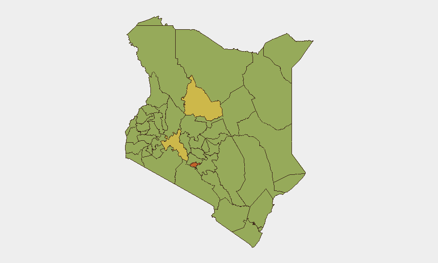
Nairobi County's dominance (risk score 74) reflects concentration of political decision-making, financial services, telecommunications hubs, and civil-society activism—each a potential flashpoint during periods of policy dispute or mass mobilization. The June 22 court ruling and scheduled June 25 protests create overlapping focal points for state and street-level tension within the capital. Nakuru and Samburu counties (both score 61) remain secondary-tier concerns driven by historical intercommunal cattle-rustling, pastoral vulnerability to al-Shabaab recruitment, and proximity to ungoverned space along the Somalia border. Migori, Uasin Gishu, and western counties (scores 45–57) present mixed risk profiles tied to inter-ethnic political competition, criminality, and periodic trade-route disruption.
How GeoBit Would Assist
Intel Sweep and multi-language OSINT fusion enable real-time tracking of protest announcements, police statements, and underground organizing across social platforms (X, Telegram, WhatsApp) to detect escalation signals and localized flashpoints before mainstream media. AOI Monitoring & Early Warning with persistent satellite and OSINT watch on Nairobi government precincts, the Ebola facility site, and known protest assembly points provide sub-24-hour alerting on crowd buildup, police deployments, and route blockage. Routing & Network Analysis calculates alternative transport corridors and supply chains to bypass anticipated demonstration zones, enabling duty-of-care teams to plan staff movement and asset logistics around protest activity.
7-Day Outlook
The June 25 anniversary is the critical inflection point; police readiness and organizational discipline will largely determine whether commemorative marches remain peaceful or escalate to confrontation. The Ebola facility court case and sentencing (expected June 23) may trigger secondary protests if the minister receives custodial punishment, widening the operational disruption window. By late June 26–27, if no major police–protester clashes occur, operational risk should recede to baseline levels, barring unforeseen political or security-sector trigger events.
Highest-Risk Areas — Ranked
| # | State / Region | Risk |
|---|---|---|
| 1 | Nairobi County | 74 |
| 2 | Nakuru | 61 |
| 3 | Samburu | 61 |
| 4 | Migori County | 57.1 |
| 5 | Uasin Gishu County | 49.2 |
| 6 | Homa Bay County | 46.6 |
| 7 | Busia County | 45.3 |
| 8 | Kajiado County | 45.3 |
| 9 | Kakamega County | 44 |
| 10 | Vihiga County | 44 |
| 11 | Nandi County | 44 |
| 12 | Elgeyo-Marakwet County | 44 |
Sources
Previous Daily Briefs
A new Kenya brief is written every day — each with its own risk map and downloadable CSV. Here's the last week; use the calendar to go further back.
📅 Browse every day by calendar →
Highlighted days have a brief. Tap a day for that day's map & analysis, or “csv” for that day's dataset ($5).