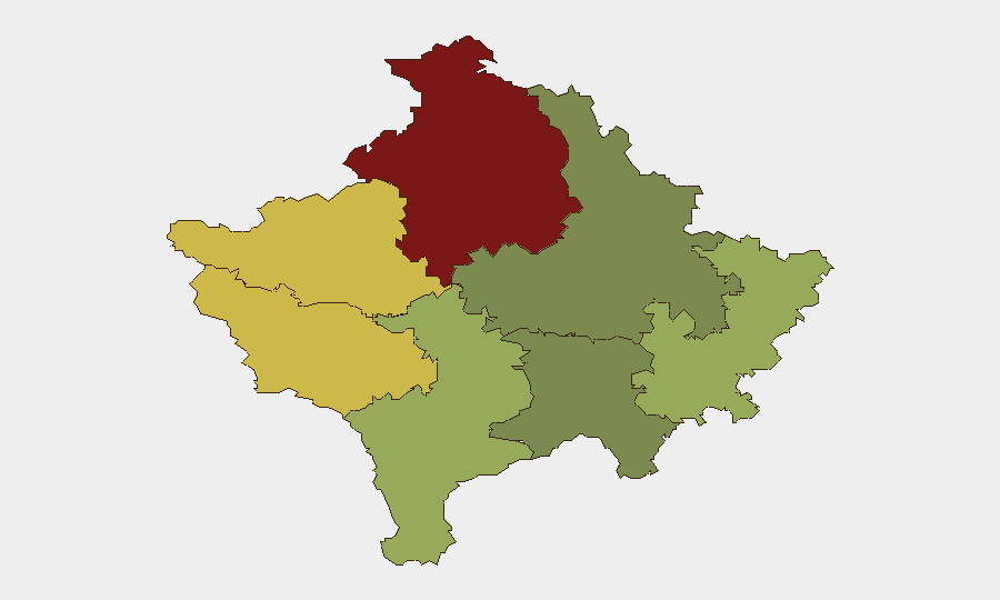
Situation Summary
Kosovo remains a low-threat environment globally (composite score 2) with no tracked discrete security events in the current reporting window. However, sub-national risk is concentrated in the north and western districts, particularly Mitrovica (risk 92), driven by ongoing Serbian–Kosovo tensions and infrastructure disputes. Recent incidents—traffic accidents, a gunfire injury, police detentions, and motorcycle enforcement operations—signal routine public-order management and road-safety challenges rather than systemic instability; the trajectory remains stable but regionally fragmented.
Key Developments
- Prizren – detention and police conduct complaint (July 26). Brčko District Mayor Siniša Milić reported six-hour detention by Kosovo Police at the Monastery of the Holy Archangels near Prizren; Serbian officials claim police also targeted civilians with children, framing the action as "repression" against Serbs. International briefings are planned.
- Vërmica (Kosovo–Albania border) – multi-vehicle highway accident (July 26). A serious traffic collision near the Vërmica checkpoint on the Ibrahim Rugova highway injured eight people, indicating road-safety risks in border-crossing corridors.
- Obiliq – fatal traffic accident (July 26). A traffic incident in central Kosovo resulted in two deaths and one injury.
- Podujeva – traffic injury update (July 26, 15:04 local time). Kosovo Police revised casualty count in a road accident upward to four injured, reflecting initial underreporting.
- Pristina region – motorcycle enforcement surge (late July, ongoing). Kosovo Police confiscated 114 motorcycles and issued enforcement measures to 535 riders across Pristina-region roads as part of a road-safety operation.
- Lipjan – gunfire injury (July 24, ~19:28). One person sustained a gunfire wound following a dispute in Brus village, Lipjan municipality; case under investigation.
Highest-Risk Areas
Mitrovica District's risk score of 92 substantially exceeds all other regions and reflects longstanding Serbian–Kosovo inter-ethnic tensions, disputed governance, and historical violence in the north. Peja (68) and Gjakova (65) in the west also carry elevated risk, likely linked to border dynamics and residual communal friction. By contrast, Prishtina (28)—the capital—and central districts show markedly lower composite scores, indicating that security volatility is geographically concentrated and does not characterize the country's urban core or southern regions.
How GeoBit Would Assist
Security and risk teams with personnel or assets in Kosovo should employ AOI Monitoring & Early Warning on Mitrovica and western border zones (Peja, Gjakova) to detect emerging inter-ethnic or police incidents before they escalate. Routing & Network Analysis supports duty-of-care planning for staff transiting high-accident corridors (Vërmica, Obiliq, Podujeva); Intel Sweep and OSINT fusion across local and regional news, Telegram, and Serbian/Albanian sources will provide real-time situational awareness on police actions, detention claims, and community sentiment that precede larger incidents.
7-Day Outlook
Road-safety incidents will likely persist; the spike in motorcycle enforcement and recent multi-vehicle collisions suggest continued traffic volatility on major corridors. Prizren's detention complaint and Serbian official response may generate diplomatic messaging but are unlikely to trigger imminent security escalation. The northern and western districts remain the only zones requiring elevated monitoring; no systemic destabilization is anticipated in the near term.
Highest-Risk Areas — Ranked
| # | State / Region | Risk |
|---|---|---|
| 1 | District of Mitrovica | 92 |
| 2 | District of Peja | 68 |
| 3 | District of Gjakova | 65 |
| 4 | District of Prizren | 55 |
| 5 | District of Gjilan | 52 |
| 6 | District of Ferizaj | 38 |
| 7 | District of Prishtina | 28 |
Sources
Previous Daily Briefs
A new Kosovo brief is written every day — each with its own risk map and downloadable CSV. Here's the last week; use the calendar to go further back.
📅 Browse every day by calendar →
Highlighted days have a brief. Tap a day for that day's map & analysis, or “csv” for that day's dataset ($5).
Atlas — our AI intelligence desk — emails them this snapshot personally. Nothing else, no list.