Situation Summary
Lebanon is experiencing acute military escalation following intensified Israeli-Hezbollah hostilities, with the Israeli Defense Forces conducting expanded ground operations into southwestern Lebanon and conducting strikes deep into populated areas including Beirut's southern suburbs. Over 1,000 injuries have been reported from coordinated detonations of pager devices used by Hezbollah members and associates, representing a significant security breach and disruption event. The conflict trajectory remains sharply upward, with rocket barrages exceeding 100 rounds toward northern Israel and UN peacekeepers killed in cross-fire, indicating sustained operational tempo with high risk of civilian casualty escalation.
Key Developments
- Beirut southern suburbs (Dahieh), 2026-06-02/01: Israeli airstrikes targeted the area overnight following televised remarks by Hezbollah deputy leader Naim Qassem; strikes reported within hours of the statement indicate real-time targeting capability and sustained pressure on senior leadership locations.
- Southwestern Lebanon (Nabatieh Governorate), 2026-06-01: Israeli military announced launch of a "limited" ground operation, expanding beyond prior clashes concentrated in southern border zones; IDF forces advanced up to 11 kilometers into Lebanese territory with intensive fighting reported.
- Southern Lebanese coastline (south of Awali River), 2026-06-01: IDF issued evacuation warnings for maritime and coastal areas, signaling preparation for expanded operations in a previously less-active sector and increasing displacement pressure.
- Northern Israel (Haifa and surrounding towns), 2026-06-01: Hezbollah fired over 100 rockets toward northern Israel in the heaviest barrage on Haifa since October 2023 escalation; demonstrates sustained offensive capability despite pager incident losses.
- Nationwide pager detonations, 2026-06-01: More than 1,000 injuries reported from coordinated detonations of pager devices across Lebanon; Hezbollah characterized the incident as the group's largest security breach in nearly one year of conflict, indicating potential compromise of supply chains or communication systems.
- Blue Line / Southern Lebanon border, 2026-06-01: UN Security Council briefing reported intense fighting across the demarcation line with IDF advances and heavy clashes; UNIFIL peacekeeping operations disrupted with fatalities among Indonesian contingent (two killed near Banihayan in roadside explosion; one killed in base explosion in Edbe).
- Litani River infrastructure, 2026-06-01: Multiple bridges over the Litani River destroyed; critical civilian infrastructure damage and displacement acceleration reported.
- Bekaa Valley, 2026-06-01: Continued Israeli strikes reported in populated Bekaa areas alongside ongoing Hezbollah military activity; civilian infrastructure and residential zones increasingly affected.
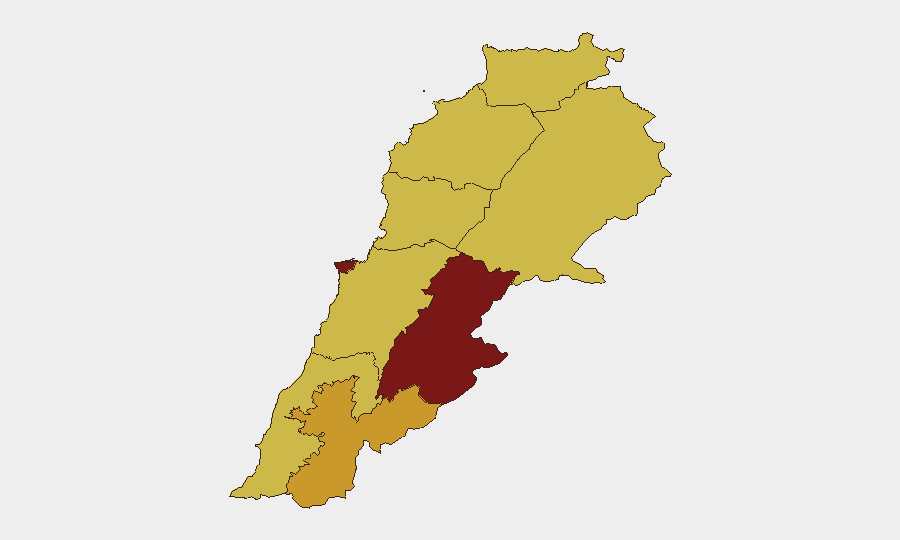
Highest-Risk Areas
Beqaa Governorate (91.1) and Beirut Governorate (82.4) dominate the risk ranking, driven by their role as operational centers and infrastructure hubs in the conflict. Beqaa's elevated score reflects its position as a primary Hezbollah stronghold and military deployment zone; Beirut's reflects dual exposure—southern suburbs (Dahieh) as a command/logistics node and the capital's role as a civilian population center vulnerable to collateral impact. The secondary tier—Nabatieh (71) and South Governorate (66)—corresponds to the active ground operation zone where IDF forces are advancing and clashes are most intense. All other governorates score above 61, indicating no safe-haven areas; nationwide risk is elevated.
How GeoBit Would Assist
Security teams managing personnel or assets in Lebanon would deploy AOI Monitoring & Early Warning on highest-risk governorates (Beqaa, Beirut southern suburbs, Nabatieh) to detect strike patterns and escalation signals in near-real-time. Battle Mapping and Force Structure tracking would correlate IDF advance rates, checkpoint movements, and Hezbollah positioning to inform routing and movement decisions. OSINT Fusion (X/Telegram/open-source signals) combined with Conflict & Military intelligence would provide corroborated awareness of command changes, supply disruptions, and tactical shifts—critical for duty-of-care decisions on shelter-in-place versus evacuation.
7-Day Outlook
The conflict trajectory indicates sustained or intensifying operations through the immediate week; the pager incident may disrupt Hezbollah coordination in the short term, but the 100+ rocket barrage suggests operational resilience. IDF ground operations are likely to consolidate in southwestern Lebanon while air operations continue targeting infrastructure and leadership nodes. Civilian displacement, infrastructure damage, and cross-border fire are expected to persist; no diplomatic off-ramps are visible in current signaling.
Highest-Risk Areas — Ranked
| # | State / Region | Risk |
|---|---|---|
| 1 | Beqaa Governorate | 91.1 |
| 2 | Beirut Governorate | 82.4 |
| 3 | Nabatieh Governorate | 71 |
| 4 | South Governorate | 66 |
| 5 | Keserwan-Jbeil Governorate | 62.9 |
| 6 | Baalbek-Hermel Governorate | 61.2 |
| 7 | North Governorate | 61.1 |
| 8 | Akkar Governorate | 61.1 |
| 9 | Mount Lebanon Governorate | 61.1 |