Situation Summary
Mali faces a rapidly deteriorating security environment characterized by a coordinated multi-front insurgency that is shifting from territorial control to economic strangulation of the capital. Al-Qaeda-linked JNIM has declared a "total siege" of Bamako and is systematically targeting supply corridors, while separatist forces (MNLA/FPLA) consolidate control in the north and Islamic State-affiliated fighters establish a new presence in the northeast. The combination of military setbacks for government and Russian forces, coupled with coordinated attacks on transport networks, signals a transition toward asymmetric pressure on Bamako's civilian economy and supply chains rather than conventional pitched battles.
Key Developments
- Bamako–Bougouni corridor (Koulikoro/Sikasso regions), 2026-06-02: JNIM-linked fighters ambushed Moroccan fruit trucks; transport unions report over 100 passenger buses stranded in Kita as drivers refuse night travel on Kita–Bamako routes, affecting passenger movement and food supply into the capital.
- Kidal region, northern Mali, 2026-06-02: MNLA/FPLA forces report seizure of Kidal city, Tessalit, and Amchach following withdrawal of Malian and Russian forces; significant military hardware abandoned and captured by armed groups, indicating dramatic erosion of state control north of the capital.
- Menaka, northeast Mali, 2026-06-01: Islamic State-linked fighters have entered Menaka and established checkpoints, creating a two-front operational challenge for Malian forces between IS units in the northeast and JNIM closer to Bamako.
- JNIM "total siege" declaration, 2026-06-02: Al-Qaeda-linked JNIM released a video declaring all access routes to Bamako blocked and warning of lethal consequences for transit attempts; Bamako authorities responded with heightened security and search-and-clear operations.
- International freight suspension, 2026-06-02: Maersk and other carriers report partial suspension of Mali operations; cargo traffic toward Senegal, Côte d'Ivoire, and Guinea faces ambush and blockade risk from insurgent groups, tightening food supplies and raising economic disruption concerns.
- Coordinated multi-city attacks, 2026-06-01: Recent wave of synchronized attacks across Bamako, Kidal, and other cities prompted Mali's junta to frame events as regime destabilization attempts; Africa Corps acknowledged withdrawal from Kidal and casualties amid ongoing multi-region combat.
Highest-Risk Areas
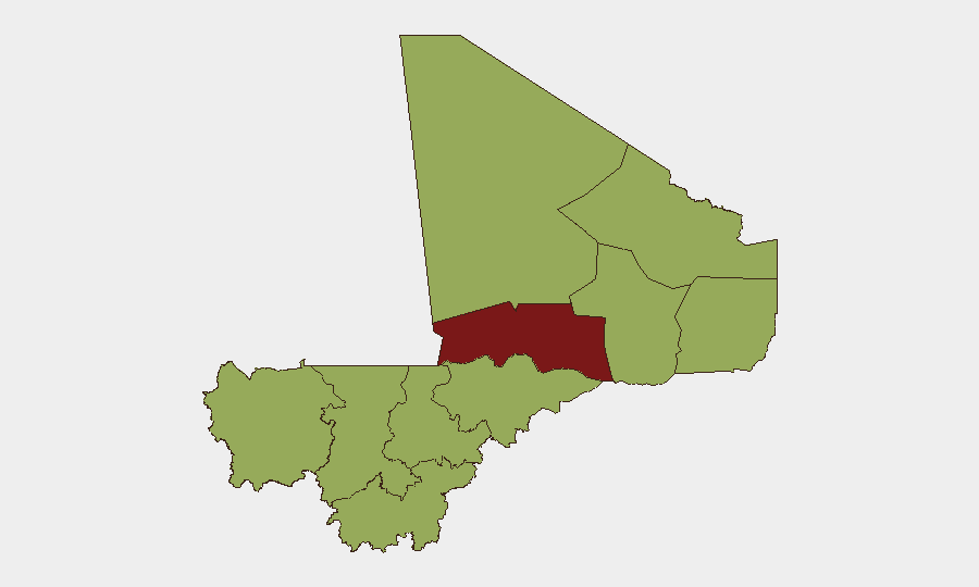
Timbuktu (89.8) stands as the single highest-risk region, but the aggregate threat to corporate and expatriate personnel concentrates in Bamako (62.1) and the road network connecting it to regional supply hubs. The capital's risk ranking reflects active siege operations by JNIM and disruption of all major transport corridors—a situation distinct from the northern and northeastern regions where territorial control by separatists and IS-linked groups creates persistent ambush and checkpoint risk. Menaka (59.8) and Kidal (59.8) present acute instability from fighter consolidation, while secondary routes via Kayes, Koulikoro, and Ségou face increasing interdiction, making overland travel to/from Bamako inherently high-risk across multiple regions.
How GeoBit Would Assist
Security teams operating in Mali should deploy AOI Monitoring & Early Warning on Bamako's perimeter and key transport corridors (Bamako–Bougouni, Kita–Bamako, routes to Senegal/Côte d'Ivoire) to track real-time blockade activity and ambush patterns. Routing & Network Analysis capabilities enable identification of alternative supply and personnel movement corridors as primary roads close. Concurrent Intel Sweep and multi-language OSINT on JNIM, MNLA, and IS-linked actors—via Telegram, local media, and militant channels—provide early signals of attack plans, checkpoints, and access restrictions before they impact operations.
7-Day Outlook
The siege of Bamako is likely to intensify over the next week, with JNIM maintaining pressure on supply corridors and possible secondary attacks on government/Russian positions to consolidate gains. Food and fuel shortages in the capital are probable if transport blockades hold, potentially triggering civil unrest. Risk of ambush on all major roads radiating from Bamako will remain acute; personnel movement should be treated as high-consequence until blockade pressure visibly relaxes.
Highest-Risk Areas — Ranked
| # | State / Region | Risk |
|---|---|---|
| 1 | Timbuktu | 89.8 |
| 2 | Bamako | 62.1 |
| 3 | Ménaka | 59.8 |
| 4 | Kayes | 59.8 |
| 5 | Taoudénit Region | 59.8 |
| 6 | Kidal | 59.8 |
| 7 | Gao | 59.8 |
| 8 | Koulikoro | 59.8 |
| 9 | Ségou Region | 59.8 |
| 10 | Sikasso Region | 59.8 |
| 11 | Mopti | 59.8 |
Previous Daily Briefs
A new Mali brief is written every day — each with its own risk map and downloadable CSV. Here's the last week; use the calendar to go further back.
📅 Browse every day by calendar →
Highlighted days have a brief. Tap a day for that day's map & analysis, or “csv” for that day's dataset ($5).