Situation Summary
Mali remains under elevated composite threat (rank #22 globally, score 94) with Bamako emerging as the single highest-risk node (96.1). Signal activity over the past 72 hours includes small-arms combat involving military forces (14 July), domestic political disapproval events (16 July), and reported unconventional violence with Russian attribution (16 July). Open-source verification of discrete incident detail in the immediate 24–48 hour window remains constrained; the threat environment reflects sustained underlying volatility rather than a sudden tactical escalation.
Key Developments
Verified recent signals (last 72 hours):
- 14 July, Mali (location unspecified) – Small-arms combat involving Malian Armed Forces (GEOBIT OSINT & event feed).
- 16 July, Mali (nationwide) – Disapproval events / civil protest activity recorded (GEOBIT Intel Sweep).
- 16 July, Mali (location unspecified) – Unconventional violence incident with Russian actor involvement or attribution flagged (GEOBIT multi-language OSINT & network analysis).
Constraint note: Open-source corroboration for granular incident location, casualty counts, and tactical detail for events within the last 48 hours remains limited. Most publicly verifiable combat operations and militant activity in the broader Mali theater are dated 5–7 days prior (early July) and fall outside the immediate reporting window. Real-time verification lags are typical in remote, conflict-affected regions with limited independent media presence.
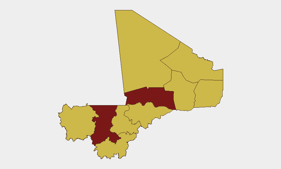
Highest-Risk Areas
Bamako (96.1) stands apart as the primary risk concentration, reflecting capital-city exposure to political instability, security force operations, and militant infiltration risk. Ségou Region (86.1) forms the second tier; it bridges central Mali's pastoral and agricultural zones with active militant presence and intercommunal tension corridors. The remaining nine regions (Ménaka, Kayes, Taoudénit, Kidal, Gao, Koulikoro, Sikasso, Timbuktu, Mopti) register equivalent composite scores (66.1), indicating widespread diffuse threat rather than a secondary hotspot model. This flat distribution across most of Mali outside Bamako and Ségou signals that militant, intercommunal, and state-fragility risks are spatially distributed; no region is reliably safe, and risk varies sharply by district and time.
How GeoBit Would Assist
Security teams operating in Mali should deploy persistent Area-of-Interest (AOI) Monitoring & Early Warning on Bamako and Ségou to detect operationally relevant event clustering before open-source lag. Conflict & Military battle mapping, force-structure tracking, and network analysis enable differentiation between routine FARMA (Malian Armed Forces) maneuver, militant group activity, and foreign military presence (including Russian unconventional operations). Routing & Network Analysis supports duty-of-care teams in identifying secure transit corridors and assessing real-time choke-point risk. OSINT Fusion & corroboration (Intel Sweep, multi-language search, X/Telegram monitoring, SIGINT) accelerates verification of rumor vs. confirmed incident when public reporting is sparse.
7-Day Outlook
Sustained pressure on Bamako governance and military capacity is likely to persist; Russian engagement signals suggest external actor interest in Mali's political-military trajectory remains active. Risk of localized militant or intercommunal flare-ups across Ségou, Gao, and Mopti regions in the coming week remains elevated but is not presently trending toward coordinated nationwide escalation. Duty-of-care and asset-protection posture should remain elevated, especially in Bamako and high-traffic zones.
Highest-Risk Areas — Ranked
| # | State / Region | Risk |
|---|---|---|
| 1 | Bamako | 96.1 |
| 2 | Ségou Region | 86.1 |
| 3 | Ménaka | 66.1 |
| 4 | Kayes | 66.1 |
| 5 | Taoudénit Region | 66.1 |
| 6 | Kidal | 66.1 |
| 7 | Gao | 66.1 |
| 8 | Koulikoro | 66.1 |
| 9 | Sikasso Region | 66.1 |
| 10 | Timbuktu | 66.1 |
| 11 | Mopti | 66.1 |
Sources
Previous Daily Briefs
A new Mali brief is written every day — each with its own risk map and downloadable CSV. Here's the last week; use the calendar to go further back.
📅 Browse every day by calendar →
Highlighted days have a brief. Tap a day for that day's map & analysis, or “csv” for that day's dataset ($5).
Atlas — our AI intelligence desk — emails them this snapshot personally. Nothing else, no list.