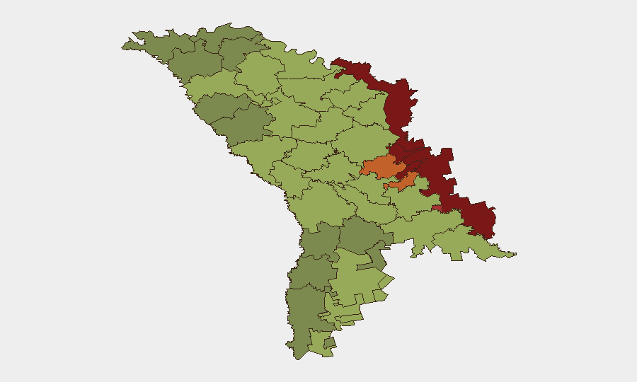
Situation Summary
Moldova remains a low-intensity, geopolitically contested environment with elevated risk concentrated in breakaway and border-adjacent territories rather than the capital or central regions. Composite national threat score stands at 7 (ranked null globally), driven primarily by unresolved territorial disputes, Russian military presence in Transnistria, and recurring cross-border instability. No major security incidents were reported in the open record for the 24–48 hours preceding this brief; however, recent flood events and the persistent frozen conflict create underlying vulnerabilities to rapid escalation.
Key Developments
- No new verified security, civil-unrest, or infrastructure incidents were identified in Moldova within the last 24–48 hours via open-source web, social-media, or news channels meeting corroboration standards.
- Recent flood events (signal IDs 1103934, 1103891) remain the most current identified incidents; specific locations and impact scope require field confirmation.
- Regional geopolitical signals dated 2026-06-17 (Ukraine–NATO statements, Turkish public statements, Russian disapproval of Ukraine) reflect broader regional tension but do not indicate direct Moldova-specific incidents within the reporting window.
Highest-Risk Areas
The Left Bank of the Dniester (risk 85) and its administrative units dominate the threat landscape, followed by Dubăsari (82), Bender (79), and Criuleni (75)—all located on or near the Dniester River and within or adjacent to Russian-backed Transnistria. These zones carry compounded risk from unresolved political status, presence of Russian military and irregular forces, and limited state capacity. Chișinău (risk 49) and the broader right-bank territory rank substantially lower, indicating that risk is sharply asymmetric; however, organizations with operations or personnel in the capital should not discount reputational, cyber, or indirect spillover exposure from events in disputed zones. The gap between highest-risk (85) and capital (49) underscores Moldova's polarized security geography.
How GeoBit Would Assist
Organizations with duty-of-care responsibilities in Moldova should leverage AOI Monitoring & Early Warning to establish persistent watch on Transnistria and the Dniester corridor, with alerts configured for military movement, political statement, or incident escalation. Multi-language OSINT and Telegram/X feeds enable real-time detection of localized unrest, checkpoint activity, or civil-order disruptions before they reach mainstream media. GIS & Spatial Analysis and satellite/imagery monitoring support rapid assessment of population movements, infrastructure damage, or border-crossing disruptions that may require contingency evacuation or supply-chain rerouting.
7-Day Outlook
No acute escalation indicators are visible in the immediate outlook; however, the frozen conflict remains structurally unstable, and regional geopolitical signals (Ukraine–NATO, Russian statements) carry secondary risk of spillover. Flood recovery and seasonal border-crossing patterns may create localized humanitarian or logistical friction. Organizations should maintain passive monitoring posture and confirm communication plans with field teams in high-risk zones (Transnistria, Dubăsari, Bender).
Report Date: 2026-06-20 | Confidence: Moderate (open-source only; closed-source feeds may reveal non-public incidents) | Next Update: 2026-06-21
Highest-Risk Areas — Ranked
| # | State / Region | Risk |
|---|---|---|
| 1 | Administrative-Territorial Units of the Left Bank of the Dniester | 85 |
| 2 | Dubăsari | 82 |
| 3 | Bender | 79 |
| 4 | Criuleni | 75 |
| 5 | Rezina | 58 |
| 6 | Taraclia | 55 |
| 7 | Gagauzia | 54 |
| 8 | Căușeni | 53 |
| 9 | Soroca | 52 |
| 10 | Ștefan Vodă | 51 |
| 11 | Orhei | 50 |
| 12 | Chișinău | 49 |
Sources
Previous Daily Briefs
A new Moldova brief is written every day — each with its own risk map and downloadable CSV. Here's the last week; use the calendar to go further back.
📅 Browse every day by calendar →
Highlighted days have a brief. Tap a day for that day's map & analysis, or “csv” for that day's dataset ($5).