Situation Summary
Myanmar remains in active civil war following the February 2021 military coup, with the junta facing sustained opposition from ethnic armed organizations (EAOs) and the People's Defence Forces (PDF) across multiple regions. Violence has intensified and spread from conflict-endemic areas into major urban centers including Yangon, Mandalay, and Naypyitaw, with aerial bombardments and cross-border instability complicating the security environment. The military has activated conscription to address manpower shortages, triggering mass youth displacement, while expanding digital surveillance in partnership with Chinese technology firms. The overall trajectory remains volatile with no near-term de-escalation signals.
Key Developments
- Namhkam Township, Shan State (2026-06-01): Explosion at rare-earth mining facility killed at least 45 people in an area controlled by the Ta'ang National Liberation Army (TNLA), exposing severe safety and regulatory failures in the unregulated mining sector and signaling infrastructure vulnerability in conflict zones.
- Myawaddy, Kayin State (2026-06-02): Myanmar's military claimed recapture of the Thai border town and expanded control of frontier trade crossings, reasserting presence over a critical cross-border trade corridor recently contested by anti-junta forces.
- KK Park cybercrime center, near Myawaddy (2026-06-02): Military announced shutdown of major cybercrime hub, detaining 2,198 people and seizing approximately 30 Starlink terminals; the area remains only loosely controlled by the junta and influenced by ethnic militias, indicating persistent law-enforcement gaps.
- Sagaing, Shan, Rakhine, Magway, Kachin, Mandalay (ongoing): High-intensity aerial bombardment campaigns by the military continue across six provinces, with opposition forces holding significant territorial control and demonstrating sustained combat capability.
- Urban expansion (2024–present): Opposition forces have expanded operations into Yangon, Mandalay, and Naypyitaw, including drone and rocket attacks on political/military infrastructure, elevating urban security risks and signaling capability to strike government centers.
- Checkpoint surveillance & movement restrictions (nationwide, ongoing): Authorities conduct frequent phone checks at checkpoints using data-extraction technology and impose heavy restrictions on internal/international travel, creating detention risks for persons with perceived opposition ties.
- Conscription activation & youth displacement (nationwide, ongoing): Mandatory conscription for men and women has triggered mass exodus of young people, compounding displacement pressures and increasing likelihood of evasion-related detentions.
Highest-Risk Areas
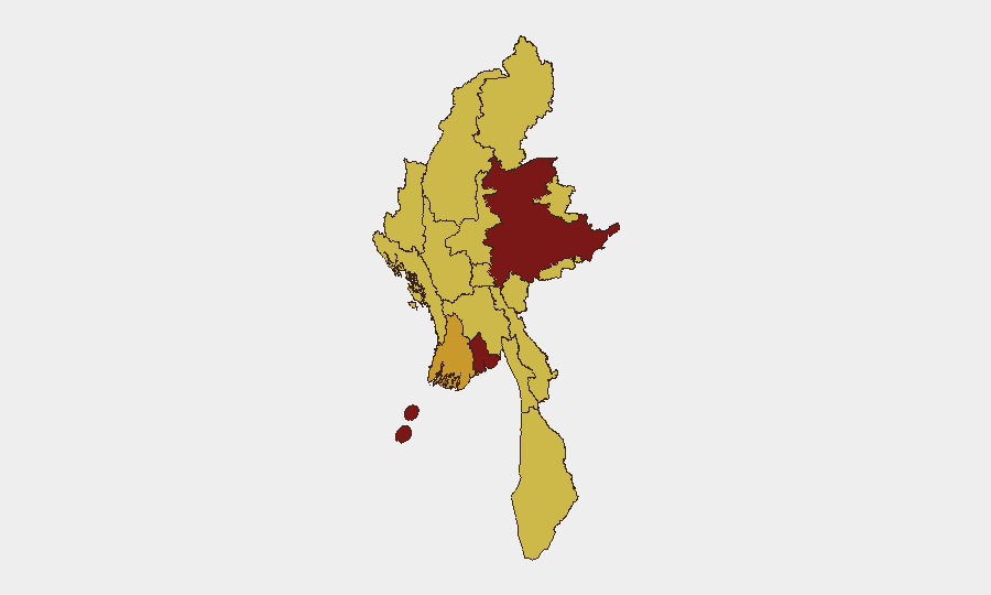
Shan State (risk 100) remains the conflict epicenter, combining active EAO control, intensive military bombardment, unregulated mining hazards, and cross-border smuggling networks. Yangon (84.5), despite being the commercial capital, now faces direct opposition operational activity and urban combat spread from peripheral regions. The southern and eastern tier—Ayeyarwady, Tanintharyi, and Kayin (via the Myawaddy corridor)—face compounding risks from EAO presence, junta reassertion attempts, cross-border trade disruption, and cybercrime infrastructure. Sagaing and Kachin remain zones of sustained aerial bombardment and territorial contestation between military and PDF/EAO forces.
How GeoBit Would Assist
Security teams would employ AOI Monitoring & Early Warning to track conflict expansion into corporate operating zones and supply routes in real time, coupled with Battle Mapping and Force Structure Analysis to assess shifting control of trade corridors and mining areas. Routing & Network Analysis capabilities enable identification of safer alternative transport and supply-chain routes around active conflict zones. OSINT fusion and multi-language event feed integration provide continuous situational updates on military operations, EAO movements, and checkpoint intensity to inform duty-of-care decisions for staff movement.
7-Day Outlook
No significant de-escalation is expected within seven days. Military operations will likely continue in Shan, Sagaing, and eastern border regions, with Myawaddy-area stability remaining contested. Urban security incidents in Yangon and Mandalay should be anticipated. Enhanced checkpoint activity and surveillance operations are probable following the KK Park raid.
Highest-Risk Areas — Ranked
| # | State / Region | Risk |
|---|---|---|
| 1 | Shan State | 100 |
| 2 | Yangon | 84.5 |
| 3 | Ayeyarwady | 71.9 |
| 4 | Tanintharyi Region | 70 |
| 5 | Chin | 70 |
| 6 | Sagaing Region | 70 |
| 7 | Kachin State | 70 |
| 8 | Wa State (Northern Region) | 70 |
| 9 | Magway | 70 |
| 10 | Mandalay | 70 |
| 11 | Rakhine | 70 |
| 12 | Naypyitaw Union Territory | 70 |
Previous Daily Briefs
A new Myanmar brief is written every day — each with its own risk map and downloadable CSV. Here's the last week; use the calendar to go further back.
📅 Browse every day by calendar →
Highlighted days have a brief. Tap a day for that day's map & analysis, or “csv” for that day's dataset ($5).